
The Hinze Dam is a rock and earth-fill embankment dam with an un-gated spillway across the Nerang River in the Gold Coast hinterland of South East, Queensland, Australia. The main purpose of the dam is for potable water supply of the Gold Coast region. The impounded reservoir is called Advancetown Lake.

The Wivenhoe Dam is a rock and earth-fill embankment dam with a concrete spillway across the Brisbane River in South East Queensland, Australia. The dam takes it names from the local Wivenhoe Pocket rural community. The dam wall is located about 80 kilometres (50 mi) by road from the centre of Brisbane. The primary purpose of the dam is the supply of potable water for the Brisbane and Ipswich regions. The dam also provides for flood mitigation control, hydroelectricity, and recreation. The impounded reservoir is called Lake Wivenhoe and the dam, the lake and a narrow strip of surrounding land forms a locality also called Lake Wivenhoe.
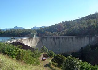
The Moogerah Dam is a mass concrete double curvature arch dam with an un-gated spillway across Reynolds Creek in South East Queensland, Australia, now within the locality of Moogerah in the Scenic Rim Region. The main purposes of the dam are for irrigation in the Reynolds Creek district and for supply of potable water to Warrill Creek and farmers in the Warrill Valley. The impounded reservoir is called Lake Moogerah.

The Maroon Dam is a rock and earth-fill embankment dam with an un-gated spillway across the Burnett Creek that is located in the South East region of Queensland, Australia. The main purpose of the dam is for irrigation of the Scenic Rim Regional Council region. The impounded reservoir is also called Maroon Dam.

The Burdekin Falls Dam, also known as the Burdekin Dam, is a concrete gravity dam with an uncontrolled spillway across the Burdekin River, located south west of Ayr, and Home Hill in the Shire of Burdekin, North Queensland, Australia. Built for the purpose of irrigation, the reservoir is called Lake Dalrymple. Burdekin Falls Dam is managed by SunWater. Water from the reservoir is also used to replenish downstream aquifers.

Lake Awoonga was formed on the Boyne River by the dam located 30 km (19 mi) from Gladstone, in Central Queensland, Australia. It is approximately 30 minutes drive from Gladstone, via Benaraby.

Glenlyon Dam, also known as Pike Creek Reservoir, is an earth and rockfill dam in Queensland near the border with New South Wales, roughly between Stanthorpe and Texas to the west. In 1976, the dam wall was built on Pike Creek, a tributary of the Dumaresq River, 5 km (3.1 mi) upstream from the confluence of the Mole River and Severn River branching from the Dumaresq. Its impoundment is known as Lake Glenlyon.
The Sideling Creek Dam is an earth-fill embankment dam with an un-gated spillway across the Sideling Creek in Kurwongbah, City of Moreton Bay, Queensland, Australia. The main purposes of the dam are for potable water supply of the City of Moreton Bay and for recreation. The impounded reservoir is called Lake Kurwongbah.

Leslie Dam is a dam in the locality of the same name Leslie Dam, Southern Downs Region, Queensland, Australia. It is 11 kilometres (6.8 mi) from Warwick town centre. Freshwater fishing and water sports facilities are available.

The Bjelke-Petersen Dam is a dam in Moffatdale near Cherbourg in the South Burnett Region, Queensland, Australia. The dam impounds Barker Creek and creates Lake Barambah. It is named after the Queensland Premier Joh Bjelke-Petersen. It is operated by Sunwater.

Boondooma Dam is a dam on the Boyne River on the boundary of Boondooma and Proston in the South Burnett Region of Queensland, Australia. From 1980 to 1983, the dam was constructed across the Boyne River below its confluence with the Stuart River, creating Lake Boondooma.

The Bill Gunn Dam is an earth-fill embankment dam with an un-gated spillway located off-stream in Laidley Heights in the South East region of Queensland, Australia. The main purpose of the dam is for irrigation of the Lockyer Valley. The resultant reservoir is called Lake Dyer.

Eungella Dam is an earth and rockfill dam in the locality of Eungella Dam, Mackay Region, Queensland, Australia. It is one of Queensland's freshwater fisheries. Eungella has made a name for producing extra oversized sooty grunter and more recently barramundi.
The Ewen Maddock Dam is an earth-fill embankment dam with an un-gated spillway across the Addlington Creek that is located in Landsborough in the South East region of Queensland, Australia. The main purpose of the dam is for potable water supply of the Sunshine Coast region.

The Baroon Pocket Dam is a rock and earth-fill embankment dam with an un-gated spillway across the Obi Obi Creek, in North Maleny, Sunshine Coast Region, in South East Queensland, Australia. The main purpose of the dam is for potable water supply. The impounded reservoir is called Lake Baroon.

The Coolmunda Dam is an earth–fill embankment dam with a gated spillway across the Macintrye Brook, a tributary of the Dumaresq River, that is located on Darling Downs in Coolmunda, Goondiwindi Region, Queensland, Australia. The main purposes of the dam are for irrigation and potable water supply. The impounded reservoir is called the Lake Coolmunda.

The Six Mile Creek Dam is a rock and earth-fill embankment dam with an un-gated spillway across the Six Mile Creek that is located in the South East region of Queensland, Australia. The main purposes of the dam are for potable water supply of the Sunshine Coast region and for recreation. The impounded reservoir is called Lake Macdonald, named in memory of former Noosa Shire Council Chairman Ian MacDonald.
Lake Lenthall is a lake created by the Lenthalls Dam in Duckinwilla, Fraser Coast Region, Queensland, Australia. As a result of a 518 square kilometres (200 sq mi) catchment, it takes a short time in moderate rain events to fill Lake Lenthall to 100% capacity.
Monduran is a rural locality in the Bundaberg Region, Queensland, Australia. In the 2016 census, Monduran had a population of 91 people.
Lake Monduran is a rural locality in the Bundaberg Region, Queensland, Australia. In the 2016 census Lake Monduran had a population of 3 people.

