
Toowoomba is a city in the Toowoomba Region of the Darling Downs, Queensland, Australia. It is 125 km (78 mi) west of Queensland's capital city Brisbane by road. The urban population of Toowoomba as of the 2021 census was 142,163, having grown at an average annual rate of 1.45% over the previous two decades. Toowoomba is the second-most-populous inland city in the country after the national capital of Canberra and hence the largest city on the Darling Downs, and it is the third largest regional centre in Queensland. It is also referred to as the capital of the Darling Downs.

The Darling Downs is a farming region on the western slopes of the Great Dividing Range in southern Queensland, Australia. The Downs are to the west of South East Queensland and are one of the major regions of Queensland. The name was generally applied to an area approximating to that of the Condamine River catchment upstream of Condamine township but is now applied to a wider region comprising the Southern Downs, Western Downs, Toowoomba and Goondiwindi local authority areas. The name Darling Downs was given in 1827 by Allan Cunningham, the first European explorer to reach the area and recognises the then Governor of New South Wales, Ralph Darling.

The Maroon Dam is a rock and earth-fill embankment dam with an un-gated spillway across the Burnett Creek that is located in the South East region of Queensland, Australia. The main purpose of the dam is for irrigation of the Scenic Rim Regional Council region. The impounded reservoir is also called Maroon Dam.

The City of Toowoomba was a local government area in the Darling Downs region of Queensland, Australia, encompassing the centre and inner suburbs of the regional city of Toowoomba. The City covered an area of 116.5 square kilometres (45.0 sq mi), and existed as a local government entity in various forms from 1860 until 2008, when it amalgamated with several other councils in the surrounding area to form the Toowoomba Region.
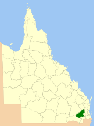
The Toowoomba Region is a local government area located in the Darling Downs part of Queensland, Australia. Established in 2008, it was preceded by several previous local government areas with histories extending back to the early 1900s and beyond.

The Somerset Region is a local government area located in the West Moreton region of South East Queensland, Australia, about 100 kilometres (62 mi) northwest of Brisbane and centred on the town of Esk. It was created in 2008 from a merger of the Shire of Esk and the Shire of Kilcoy. It is commonly known as the Brisbane Valley, due to the Brisbane River which courses through the region, although significant parts of the region lie outside the hydrological Brisbane Valley itself.

Crows Nest is a rural town and locality in the Toowoomba Region, Queensland, Australia. The town is located in the Darling Downs on the New England Highway, 158 kilometres (98 mi) from the state capital, Brisbane and 43 kilometres (27 mi) from the nearby city of Toowoomba. In the 2016 census, Crows Nest had a population of 2160 people.
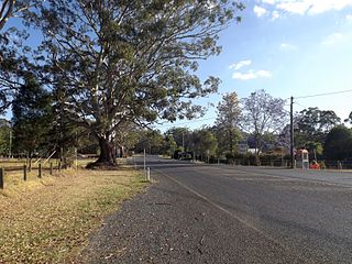
Hampton is a rural town and locality in the Toowoomba Region, Queensland, Australia. In the 2016 census, the locality of Hampton had a population of 356 people.

Cressbrook Dam is one of the three water storages used to supply Toowoomba and the surrounding region in Queensland, Australia. The dam is 33 km (21 mi) north-east of Toowoomba in the locality of Biarra in the Somerset Region. It was constructed in 1983 for the former Toowoomba City Council. The other two storages used for Toowoomba are Perseverance Dam and Cooby Dam.

The Cooby Dam is a rock–fill embankment dam with an un–gated spillway across the Cooby Creek, a tributary of Condamine River, at Groomsville in the Darling Downs region of Queensland, Australia. The main purpose of the dam is for potable water supply of the Toowoomba region. The impounded reservoir is called the Cooby Creek Reservoir.

The Baroon Pocket Dam is a rock and earth-fill embankment dam with an un-gated spillway across the Obi Obi Creek, in North Maleny, Sunshine Coast Region, in South East Queensland, Australia. The main purpose of the dam is for potable water supply. The impounded reservoir is called Lake Baroon.
Lake Manchester Dam is a concrete gravity dam with an un-gated spillway across Cabbage Tree Creek. It is also known as Cabbage Tree Creek Dam. It is in the locality of Lake Manchester, City of Brisbane, Queensland, Australia. The main purpose of the dam is for potable water supply of Brisbane. The impounded reservoir is called Lake Manchester.

The Connolly Dam, also called the Silverwood Dam, is a rock–fill embankment dam with an un–gated spillway across the Rosenthall Creek and the Fitz Creek that is located in the locality of Silverwood, Southern Downs Region, part of the Darling Downs district of Queensland, Australia. The main purpose of the dam is for potable water supply of the Southern Downs Region. It discharges via Rosenthal Creek to join the Condamine River in east Warwick.

Mount Kynoch is a rural locality in the Toowoomba Region, Queensland, Australia. In the 2016 census, Mount Kynoch had a population of 237 people.

Ravensbourne is a rural locality in the Toowoomba Region, Queensland, Australia. In the 2016 census, Ravensbourne had a population of 248 people.
Grapetree is a rural locality in the Toowoomba Region, Queensland, Australia. In the 2016 census Grapetree had a population of 32 people.
Pierces Creek is a rural locality in the Toowoomba Region, Queensland, Australia. It was formerly known as Virginia. In the 2016 census, Pierces Creek had a population of 70 people.
Pinelands is a rural locality in the Toowoomba Region, Queensland, Australia. In the 2016 census, Pinelands had a population of 86 people.
Biarra is a rural locality in the Somerset Region, Queensland, Australia. In the 2016 census, Biarra had a population of 257 people.
