
Croydon is a town and locality within the Shire of Croydon in Queensland, Australia. It is a terminus for the Normanton to Croydon railway line, which operates the Gulflander tourist train. At the 2016 census, Croydon had a population of 258 people.

The Norman River is a river in the Gulf Country, Queensland, Australia. The river originates in the Gregory Range 200 km southeast of Croydon and flows 420 km northwest to the Gulf of Carpentaria. It is joined by three major tributaries, the Carron, Clara and Yappar Rivers. The river flows through Normanton before entering the Gulf of Carpentaria through the major fishing port of Karumba. The mouth of the river lies in the Gulf Plains Important Bird Area.
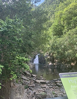
Copperlode Falls Dam or Lake Morris is a fresh water reservoir dam in Lamb Range, Cairns Region, Queensland, Australia, servicing the city of Cairns. The dam is located in the range immediately west of Cairns.

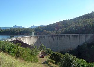
The Somerset Dam is a mass concrete gravity dam with a gated spillway across the Stanley River in Queensland, Australia. It is within the locality of Somerset Dam in the Somerset Region in South East Queensland. The main purpose of the dam is the supply of potable water for the Brisbane, Gold Coast and Logan City regions. Additionally, the dam provides for flood mitigation, recreation and for the generation of hydroelectricity. The impounded reservoir is called Lake Somerset.

The Hinze Dam is a rock and earth-fill embankment dam with an un-gated spillway across the Nerang River in the Gold Coast hinterland of South East, Queensland, Australia. The main purpose of the dam is for potable water supply of the Gold Coast region. The impounded reservoir is called Advancetown Lake.

The Wivenhoe Dam is a rock and earth-fill embankment dam with a concrete spillway across the Brisbane River in South East Queensland, Australia. The dam wall is located about 80 kilometres (50 mi) by road from the centre of Brisbane. The primary purpose of the dam is the supply of potable water for the Brisbane and Ipswich regions. The dam also provides for flood mitigation control, hydroelectricity, and recreation. The impounded reservoir is called Lake Wivenhoe and the dam, the lake and a narrow strip of surrounding land forms a locality also called Lake Wivenhoe.
The Moogerah Dam is a mass concrete double curvature arch dam with an un-gated spillway across the Reynolds Creek that is located in the South East region of Queensland, Australia. The main purposes of the dam are for irrigation of the Reynolds Creek and for supply of potable water to Warrill Creek and farmers in the Warrill Valley. The impounded reservoir is called Lake Moogerah.

The North Pine Dam is a mass concrete gravity dam with earth-fill embankments on abutments with a gated spillway across the North Pine River that is located in the South East region of Queensland, Australia. The main purpose of the dam is for supply of potable water for the Moreton Bay region and Brisbane's northern suburbs. The impounded reservoir is called Lake Samsonvale.
The Sideling Creek Dam is an earth-fill embankment dam with an un-gated spillway across the Sideling Creek in Kurwongbah, Moreton Bay Region, Queensland, Australia. The main purposes of the dam are for potable water supply of the Moreton Bay Region and for recreation. The impounded reservoir is called Lake Kurwongbah.

The Bjelke-Petersen Dam is a dam in Moffatdale near Cherbourg in the South Burnett Region, Queensland, Australia. The dam impounds Barker Creek and creates Lake Barambah. It is named after the Queensland Premier Joh Bjelke-Petersen. It is operated by Sunwater.

Boondooma Dam is a dam on the Boyne River on the boundary of Boondooma and Proston in the South Burnett Region of Queensland, Australia. In 1983, the dam was constructed across the Boyne River below its confluence with the Stuart River, creating Lake Boondooma.
The Lake Clarendon Dam is a rock and earth-fill embankment dam with an un-gated spillway located off-stream in the locality of Lake Clarendon in the Lockyer Valley Region, South East Queensland, Australia. The main purpose of the dam is for irrigation of the Lockyer Valley. The resultant impounded reservoir is called Lake Clarendon.
The Ewen Maddock Dam is an earth-fill embankment dam with an un-gated spillway across the Addlington Creek that is located in Landsborough in the South East region of Queensland, Australia. The main purpose of the dam is for potable water supply of the Sunshine Coast region.

The Baroon Pocket Dam is a rock and earth-fill embankment dam with an un-gated spillway across the Obi Obi Creek, in North Maleny, Sunshine Coast Region, in South East Queensland, Australia. The main purpose of the dam is for potable water supply. The impounded reservoir is called Lake Baroon.
The Koombooloomba Dam is a concrete gravity dam with a controlled spillway across the Tully River, located west of Tully and south, southeast of Ravenshoe in Far North Queensland, Australia. Built for the purpose of hydroelectric power generation, the dam creates the reservoir, Lake Koombooloomba.
Lake Manchester Dam is a concrete gravity dam with an un-gated spillway across Cabbage Tree Creek. It is also known as Cabbage Tree Creek Dam. It is in the locality of Lake Manchester, City of Brisbane, Queensland, Australia. The main purpose of the dam is for potable water supply of Brisbane. The impounded reservoir is called Lake Manchester.

The Normanton to Croydon railway line is a heritage-listed railway line in the Gulf Country of northern Queensland, Australia. The railway line linking Normanton in the Shire of Carpentaria to Croydon in the Shire of Croydon was built between 1888 and 1891 and is the last isolated line of Queensland Rail still in use. It utilises an innovative system of submersible track with patented steel sleepers and retains buildings of considerable architectural and technical interest at its terminus in Normanton. The only train to operate on the line is the weekly Gulflander service operated by a Gardner diesel propelled railmotor and carriages TP1809 and TP1811.
Lake Borumba is a rural locality in the Gympie Region, Queensland, Australia. In the 2016 census Lake Borumba had a population of 6 people.
Monduran is a rural locality in the Bundaberg Region, Queensland, Australia. In the 2016 census, Monduran had a population of 91 people.
Kinchant Dam is a rural locality in the Mackay Region, Queensland, Australia. In the 2016 census Kinchant Dam had a population of 123 people.

