
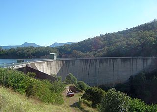
Dartmouth Dam is a large rock-fill embankment dam with an uncontrolled chute spillway across the Mitta Mitta, Gibbo and Dart rivers, the Morass Creek and a number of small tributaries. The dam is located near Mount Bogong in the north-east of the Australian state of Victoria. The dam's purpose includes irrigation, the generation of hydro-electric power, water supply and conservation. The impounded reservoir is called Dartmouth Reservoir, sometimes called Lake Dartmouth. The Dartmouth Power Station, a hydro-electric power station that generates power to the national grid, is located near the dam wall.

The Eildon Dam is a rock and earth-fill embankment dam with a controlled spillway across the Goulburn River, is located between the regional towns of Mansfield and Eildon within Lake Eildon National Park, in the Alpine region of Victoria, Australia. The dam's purpose is for the supply of potable water, irrigation, and the generation of hydroelectricity. The impounded reservoir is called Lake Eildon.

The Somerset Dam is a mass concrete gravity dam with a gated spillway across the Stanley River in Queensland, Australia. It is within the locality of Somerset Dam in the Somerset Region in South East Queensland. The main purpose of the dam is the supply of potable water for the Brisbane, Gold Coast and Logan City regions. Additionally, the dam provides for flood mitigation, recreation and for the generation of hydroelectricity. The impounded reservoir is called Lake Somerset.

The Hinze Dam is a rock and earth-fill embankment dam with an un-gated spillway across the Nerang River in the Gold Coast hinterland of South East, Queensland, Australia. The main purpose of the dam is for potable water supply of the Gold Coast region. The impounded reservoir is called Advancetown Lake.
The Moogerah Dam is a mass concrete double curvature arch dam with an un-gated spillway across Reynolds Creek in South East Queensland, Australia, now within the locality of Moogerah in the Scenic Rim Region. The main purposes of the dam are for irrigation in the Reynolds Creek district and for supply of potable water to Warrill Creek and farmers in the Warrill Valley. The impounded reservoir is called Lake Moogerah.

The Leslie Harrison Dam is an earth-fill embankment dam across the Tingalpa Creek that is located in the South East region of Queensland, Australia. The main purpose of the dam is for potable water supply of the Redland City in Brisbane. The impounded reservoir is called Tingalpa Reservoir. The dam was named after Robert Leslie Harrison, a Queensland parliamentarian who died in April 1966.

The Maroon Dam is a rock and earth-fill embankment dam with an un-gated spillway across the Burnett Creek that is located in the South East region of Queensland, Australia. The main purpose of the dam is for irrigation of the Scenic Rim Regional Council region. The impounded reservoir is also called Maroon Dam.
The North Pine Dam is a mass concrete gravity dam with earth-fill embankments on abutments with a gated spillway across the North Pine River that is located in the South East region of Queensland, Australia. The main purpose of the dam is for supply of potable water for the Moreton Bay region and Brisbane's northern suburbs. The impounded reservoir is called Lake Samsonvale.

The Little Nerang Dam is a concrete gravity dam with an un-gated spillway across the Little Nerang Creek that is located in the South East region of Queensland, Australia. The main purpose of the dam is for potable water supply of the Gold Coast region. The impounded reservoir is also called Little Nerang Dam. The dam was closed to the public in 2013 due to safety concerns.
The Nillahcootie Dam, a rock and earth-fill embankment dam with a unique Gothic arch-shaped crest spillway across the Broken River that is located near Mansfield, in the Alpine region of Victoria, Australia. The dam's purpose is for the supply of potable water and for irrigation. The impounded reservoir is called Lake Nillahcootie.
Pindari Dam is a minor concrete faced rockfill embankment dam with an ungated uncontrolled rock cut with concrete sill spillway across the Severn River located upstream of the town of Ashford, in the North West Slopes region of New South Wales, Australia. The dam's purpose includes flood mitigation, hydro-power, irrigation, water supply and conservation. The impounded reservoir is called Lake Pindari.

The Atkinson Dam is an earth-fill embankment dam across the Buaraba Creek and a naturally forming lagoon, which is located near Lowood in the South East region of Queensland, Australia. The main purpose of the dam is for irrigation of farming land in the lower Lockyer Valley. The resultant reservoir is called Lake Atkinson.

The Cooby Dam is a rock–fill embankment dam with an un–gated spillway across the Cooby Creek, a tributary of Condamine River, at Groomsville in the Toowoomba Region on the Darling Downs, Queensland, Australia. The main purpose of the dam is for potable water supply of the Toowoomba region. The impounded reservoir is called the Cooby Creek Reservoir.
The Borumba Dam is a rock-fill embankment dam with an un-gated spillway located across the Yabba Creek, a tributary of the Mary River, in the Wide Bay–Burnett region of Queensland, Australia. The main purposes of the dam are for irrigation and potable water supply. The resultant impounded reservoir is called Lake Borumba.

The Bill Gunn Dam is an earth-fill embankment dam with an un-gated spillway located off-stream in Laidley Heights in the South East region of Queensland, Australia. The main purpose of the dam is for irrigation of the Lockyer Valley. The resultant reservoir is called Lake Dyer.
The Ewen Maddock Dam is an earth-fill embankment dam with an un-gated spillway across the Addlington Creek that is located in Landsborough in the South East region of Queensland, Australia. The main purpose of the dam is for potable water supply of the Sunshine Coast region.
The Callide Dam is an earth and rock-fill dam which was constructed in 1965 to supply water for the Callide Power Station in Mount Murchison near Biloela in the state of Queensland, Australia. The impoundment of the dam is Lake Callide, which holds 136,370 megalitres (3.603×10¹⁰ US gal) at an average depth of 10.5 metres (34 ft) and a surface area of 1,240 hectares (3,100 acres) at full capacity.

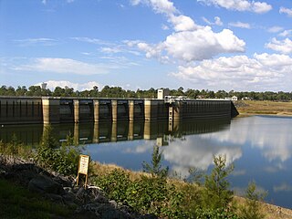
The Coolmunda Dam is an earth–fill embankment dam with a gated spillway across the Macintrye Brook, a tributary of the Dumaresq River, that is located on Darling Downs in Coolmunda, Goondiwindi Region, Queensland, Australia. The main purposes of the dam are for irrigation and potable water supply. The impounded reservoir is called the Lake Coolmunda.
Lake Manchester Dam is a concrete gravity dam with an un-gated spillway across Cabbage Tree Creek. It is also known as Cabbage Tree Creek Dam. It is in the locality of Lake Manchester, City of Brisbane, Queensland, Australia. The main purpose of the dam is for potable water supply of Brisbane. The impounded reservoir is called Lake Manchester.

The Six Mile Creek Dam is a rock and earth-fill embankment dam with an un-gated spillway across the Six Mile Creek that is located in the South East region of Queensland, Australia. The main purposes of the dam are for potable water supply of the Sunshine Coast region and for recreation. The impounded reservoir is called Lake Macdonald, named in memory of former Noosa Shire Council Chairman Ian MacDonald.
