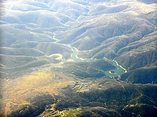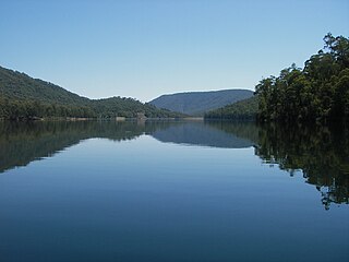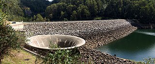
The Eildon Dam is a rock and earth-fill embankment dam with a controlled spillway across the Goulburn River, is located between the regional towns of Mansfield and Eildon within Lake Eildon National Park, in the Alpine region of Victoria, Australia. The dam's purpose is for the supply of potable water, irrigation, and the generation of hydroelectricity. The impounded reservoir is called Lake Eildon.

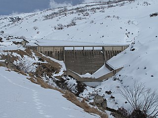
The Blowering Dam is a major ungated rock fill with clay core embankment dam with concrete chute spillway impounding a reservoir under the same name. It is located on the Tumut River upstream of Tumut in the Snowy Mountains region of New South Wales, Australia. Purposes for the dam include flood mitigation, hydro-power, irrigation, water supply and conservation. The dam is part of the Snowy Mountains Scheme, a vast hydroelectricity and irrigation complex constructed in south-east Australia between 1949 and 1974 and now run by Snowy Hydro.

Guthega Power Station is located in the Snowy Mountains region of New South Wales, Australia. The power station's purpose is for the generation of electricity. It is the first to be completed and smallest of the initial seven hydroelectric power stations that comprise the Snowy Mountains Scheme, a vast hydroelectricity and irrigation complex constructed in south-east Australia between 1949 and 1974 and now run by Snowy Hydro.

The Tumut Hydroelectric Power Stations is a series of three hydroelectric power stations on the Tumut River in New South Wales, Australia, that are part of the Snowy Mountains Scheme.
The Kareeya Hydro Power Station near Tully in Queensland, Australia in a hydroelectric power station that began generating power in 1957. It has a capacity of 88 megawatts (118,000 hp) which is fed into the National Electricity Market. The power station is owned by CleanCo Queensland.

The El Chocón Dam is the fourth of the five dams on the Limay River in the northwestern Argentine Patagonia, at 381 metres (1,250 ft) above mean sea level. El Chocón is on the Limay River at about 80 km (50 mi) upstream of its confluence with the Neuquén River.

The Burdekin Falls Dam, also known as the Burdekin Dam, is a concrete gravity dam with an uncontrolled spillway across the Burdekin River, located south west of Ayr, and Home Hill in the Shire of Burdekin, North Queensland, Australia. Built for the purpose of irrigation, the reservoir is called Lake Dalrymple. Burdekin Falls Dam is managed by SunWater. Water from the reservoir is also used to replenish downstream aquifers.

The William Hovell Dam is a rock and earth-fill embankment dam with a flip bucket chute spillway across the King River, operated by Pacific Blue and located in the Hume region of Victoria, Australia. The purposes of the dam are for irrigation and the generation of hydroelectricity. The impounded reservoir is called Lake William Hovell.
Pindari Dam is a minor concrete faced rockfill embankment dam with an ungated uncontrolled rock cut with concrete sill spillway across the Severn River located upstream of the town of Ashford, in the North West Slopes region of New South Wales, Australia. The dam's purpose includes flood mitigation, hydro-power, irrigation, water supply and conservation. The impounded reservoir is called Lake Pindari.

Talbingo Dam is a major ungated rock fill with clay core embankment dam with concrete chute spillway across the Tumut River upstream of Talbingo in the Snowy Mountains region of New South Wales, Australia. The impounded reservoir is called Talbingo Reservoir.

Tumut Pond Dam is a major gated concrete arch dam across the upper reaches of the Tumut River in the Snowy Mountains of New South Wales, Australia. The dam's main purpose is for the generation of hydro-power and is one of the sixteen major dams that comprise the Snowy Mountains Scheme, a vast hydroelectricity and irrigation complex constructed in south-east Australia between 1949 and 1974 and now run by Snowy Hydro.

The Splityard Creek Dam is a rock and earth-fill embankment dam with an un-gated spillway across the Pryde Creek that is located in the South East region of Queensland, Australia. The sole purpose of the dam is for the generation of hydroelectricity. The impounded reservoir is called the Splityard Creek Reservoir.

Jounama Dam is a major ungated rockfill embankment dam across the Tumut River in the Snowy Mountains of New South Wales, Australia. The dam's main purpose is for the generation of hydro-power and is one of the sixteen major dams that comprise the Snowy Mountains Scheme, a vast hydroelectricity and irrigation complex constructed in south-east Australia between 1949 and 1974 and now run by Snowy Hydro.
Tumut Two Dam or Tumut Two is a major ungated concrete gravity dam across the upper reaches of the Tumut River in the Snowy Mountains of New South Wales, Australia. The dam's main purpose is for the generation of hydro-power and is one of the sixteen major dams that comprise the Snowy Mountains Scheme, a vast hydroelectricity and irrigation complex constructed in south-east Australia between 1949 and 1974 and now run by Snowy Hydro.

Geehi Dam is a major ungated rockfill embankment dam across the Geehi River in the Snowy Mountains of New South Wales, Australia. The reservoir impounded by the dam is known as Geehi Reservoir.

Guthega Dam is concrete gravity dam with an uncontrolled spillway across the Snowy River in the Snowy Mountains of New South Wales, Australia. The dam's main purpose is for the storage of water used in the generation of hydro-power. It is the first to be completed of the sixteen major dams of the Snowy Mountains Scheme, a vast hydroelectricity and irrigation complex constructed in south-east Australia between 1949 and 1974 and now run by Snowy Hydro.
Khancoban Dam is a major ungated earthfill embankment dam with a controlled spillway across the Swampy Plain River in the Snowy Mountains region of New South Wales, Australia. The dam's main purpose is for the generation of hydro-power and is one of the sixteen major dams that comprise the Snowy Mountains Scheme, a vast hydroelectricity and irrigation complex constructed in south-east Australia between 1949 and 1974 and now run by Snowy Hydro.
Murray Two Dam or Murray 2 Dam is a major ungated concrete arch dam with a controlled spillway across Khancoban Bank, a diverted flow of the Snowy and Geehi rivers in the Snowy Mountains region of New South Wales, Australia. The impounded reservoir is called the Murray Two Pondage or Murray 2 Pondage.
The Bumbuna Dam is a concrete-face rock-fill dam on the Seli River near Bumbuna in Tonkolili District, Sierra Leone, and 350 kilometres (220 mi) from the capital of Freetown, the main consumer. The country's first hydroelectric dam, it supports a 50-megawatt (67,000 hp) power station.

The Vorotan Cascade, or the ContourGlobal Hydro Cascade, is a cascade on the Vorotan River in Syunik Province, Armenia. It was built to produce hydroelectric power and provide irrigation water. The Vorotan Cascade consists of three hydroelectric power plants and five reservoirs with a combined installed capacity of 404.2 MW. It is one of the main power generation complexes in Armenia.


