
The Burdekin River is a river located in North and Far North Queensland, Australia. The river rises on the northern slopes of Boulder Mountain at Valley of Lagoons, part of the western slope of the Seaview Range, and flows into the Coral Sea at Upstart Bay over 200 kilometres (124 mi) to the southeast of the source, with a catchment area of approximately 130,000 square kilometres (50,000 sq mi). The Burdekin River is Australia's largest river by (peak) discharge volume.

The Somerset Dam is a mass concrete gravity dam with a gated spillway across the Stanley River in Queensland, Australia. It is within the locality of Somerset Dam in the Somerset Region in South East Queensland. The main purpose of the dam is the supply of potable water for the Brisbane, Gold Coast and Logan City regions. Additionally, the dam provides for flood mitigation, recreation and for the generation of hydroelectricity. The impounded reservoir is called Lake Somerset.

Copeton Dam is a major clay core and rock fill embankment dam with nine radial gates and a gated concrete chute spillway across the Gwydir River upstream of Bingara in the New England region of New South Wales, Australia. The dam's purpose includes environmental flows, hydro-electric power generation, irrigation, and water supply. The impounded reservoir is called Lake Copeton.

The Wivenhoe Dam is a rock and earth-fill embankment dam with a concrete spillway across the Brisbane River in South East Queensland, Australia. The dam wall is located about 80 kilometres (50 mi) by road from the centre of Brisbane. The primary purpose of the dam is the supply of potable water for the Brisbane and Ipswich regions. In addition, the dam also provides for flood mitigation control, hydroelectricity and for recreation. The impounded reservoir is called Lake Wivenhoe and the dam, the lake and a narrow strip of surrounding land forms a locality also called Lake Wivenhoe.
Tallowa Dam, completed in 1976, is a concrete gravity dam with central overflow spillway, located on the Shoalhaven River, downstream from the river's confluence with the Kangaroo River. The dam wall of 325 cubic metres (11,500 cu ft) is 43 metres (141 ft) high and 528 metres (1,732 ft) in length. At 100% capacity, the dam wall holds back approximately 85,500 megalitres and creates the impounded reservoir of Lake Yarrunga that has a surface area of 831 hectares, drawn from a catchment area of 5,750 square kilometres (2,220 sq mi). The spillway has a discharge capacity of 27,600 cubic metres per second (970,000 cu ft/s).
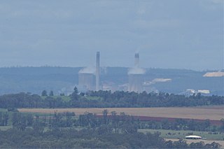
The Tarong Power Station is a coal fired power station located on a 1,500 hectares site in Tarong in the South Burnett Region near the Burnett River and Nanango, in Queensland, Australia. The station has a maximum generating capacity of 1,400 megawatts, generated from four turbines. Coal is supplied via a conveyor from Meandu Mine, which is 1.5 kilometres (0.93 mi) away and is also owned by Stanwell.

The Little Nerang Dam is a concrete gravity dam with an un-gated spillway across the Little Nerang Creek that is located in the South East region of Queensland, Australia. The main purpose of the dam is for potable water supply of the Gold Coast region. The impounded reservoir is also called Little Nerang Dam. The dam was closed to the public in 2013 due to safety concerns.

Stanwell Corporation is a Queensland government-owned corporation. It is the state's largest electricity generator and Australia’s third-largest greenhouse gas emitter.

The Atkinson Dam is an earth-fill embankment dam across the Buaraba Creek and a naturally forming lagoon, which is located near Lowood in the South East region of Queensland, Australia. The main purpose of the dam is for irrigation of farming land in the lower Lockyer Valley. The resultant reservoir is called Lake Atkinson.

The Cooby Dam is a rock–fill embankment dam with an un–gated spillway across the Cooby Creek, a tributary of Condamine River, at Groomsville in the Darling Downs region of Queensland, Australia. The main purpose of the dam is for potable water supply of the Toowoomba region. The impounded reservoir is called the Cooby Creek Reservoir.

The Baroon Pocket Dam is a rock and earth-fill embankment dam with an un-gated spillway across the Obi Obi Creek, in North Maleny, Sunshine Coast Region, in South East Queensland, Australia. The main purpose of the dam is for potable water supply. The impounded reservoir is called Lake Baroon.

The Splityard Creek Dam is a rock and earth-fill embankment dam with an un-gated spillway across the Pryde Creek that is located in the South East region of Queensland, Australia. The sole purpose of the dam is for the generation of hydroelectricity. The impounded reservoir is called the Splityard Creek Reservoir.

The Lake Manchester Dam is a concrete gravity dam with an un-gated spillway across the Cabbage Tree Creek that is located in the South East region of Queensland, Australia. The main purpose of the dam is for potable water supply of Brisbane. The impounded reservoir is called Lake Manchester.
The Six Mile Creek Dam is a rock and earth-fill embankment dam with an un-gated spillway across the Six Mile Creek that is located in the South East region of Queensland, Australia. The main purposes of the dam are for potable water supply of the Sunshine Coast region and for recreation. The impounded reservoir is called Lake Macdonald, named in memory of former Noosa Shire Council Chairman Ian MacDonald.

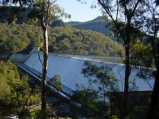
The Wyaralong Dam is a mass concrete gravity dam with an un-gated spillway across the Teviot Brook that is located in the South East region of Queensland, Australia. The main purpose of the dam is for supply of potable water for the Scenic Rim region. The impounded reservoir is also called Wyaralong Dam. The dam was initiated by the Queensland Government in 2006 as a result of a prolonged drought which saw the catchment areas of South East Queensland's dams receive record low rain.
Kidston Dam also known as Copperfield Dam is a dam in Lyndhurst, Shire of Etheridge, Queensland, Australia. It is approximately 200 kilometres (120 mi) north of Hughenden and was built for the Kidston Gold Mine. The mine closed July 2001. The lake created by the dam has a capacity of 20,600 megalitres.
Middle Creek Dam is located at the head waters of Plane Creek west of Sarina, Queensland. It was constructed in the late 1950s-early 1960s by the Sarina Shire Council and Plane Creek Sugar Mill to augment water supply from two weirs downstream that had been built in 1926 and 1935. It has a small catchment of 7.4 square kilometres and a capacity of 1,120 megalitres. The dam is used for water skiing by the Sarina Ski Club. The dam wall and spillway were upgraded by Mackay Regional Council in 2015 to improve flood capacity.

Clarrie Hall Dam is a minor ungated concrete faced rockfill embankment dam with an uncontrolled concrete-lined chute spillway across the Doon Doon Creek, located upstream of the small town of Uki, in the Northern Rivers region of New South Wales, Australia. The main purpose of the dam is for water supply and it creates the artificial Lake Clarrie Hall.
Tarong is a rural locality in the South Burnett Region, Queensland, Australia.

Lake Murchison is a man-made water reservoir located in the western region of Tasmania, Australia. The lake is situated within the northern part of Tasmania's West Coast Range and is fed by the Murchison River, the George Creek, the Anthony River, and discharge from the Tribute Power Station.
