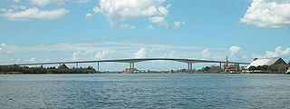
The Sir Leo Hielscher Bridges, formerly and still collectively referred to as the Gateway Bridge, are a pair of twin road bridges that carry the Gateway Motorway (M1) over the Brisbane River, skirting the eastern suburbs of the city of the same name. The western bridge carries traffic to the north and the eastern bridge carries traffic to the south. They are the most eastern crossings of the Brisbane River and the closest to Moreton Bay, crossing at the Quarries Reach and linking the suburbs of Eagle Farm and Murarrie. The original western bridge was opened on 11 January 1986 and cost A$92 million to build. The duplicate bridge was opened in May 2010, and cost $350 million.

The Bruce Highway is a major highway in Queensland, Australia. Commencing in the state capital, Brisbane, it passes through areas close to the eastern coast on its way to Cairns in Far North Queensland. The route is part of the Australian National Highway and also part of Highway 1, the longest highway route in Australia. Its length is approximately 1,679 kilometres (1,043 mi); it is entirely sealed with bitumen. The highway is named after a popular former Queensland and federal politician, Harry Bruce. Bruce was the state Minister for Works in the mid-1930s when the highway was named after him. The highway once passed through Brisbane, but was truncated at Bald Hills when the Gateway Motorway became National Highway 1 upon its opening in December 1986.

The Brooker Highway is a highway in the Australian state of Tasmania. As one of Hobart's three major radials, the highway connects traffic from the city centre with the northern suburbs and is the major road connection to the cities and towns of northern Tasmania. With an annual average daily traffic of 48,000, the highway is one of the busiest in Tasmania. The Brooker Highway has recently been declared part of the National Highway.

The Tasman Highway is a highway in Tasmania, Australia. Like the Midland Highway, it connects the major cities of Hobart and Launceston – however it takes a different route, via the north-eastern and eastern coasts of the state. The Highway also acts as a major commuter road to Hobart residents living on the eastern side of the Derwent River. The designation "Tasman Highway" arises from its location facing the Tasman Sea – named, like the state itself, after Abel Tasman. The highway is one of the longest in Tasmania – 410 km (250 mi), with an average travelling time of 41⁄2 hours.

The Houghton Highway is a 2.74 km (1.70 mi) reinforced concrete viaduct, the second bridge to be built across Hays Inlet at Bramble Bay connecting the cities of Redcliffe and Brisbane in Queensland, Australia. The bridge, along with the third bridge, the Ted Smout Memorial Bridge, were the longest bridges in the country until 27 March 2013, when the Macleay River Bridge opened in Kempsey, NSW.

The Warrego Highway is located in southern Queensland, Australia. It connects coastal centres to the south western areas of the state, and is approximately 715 km in length. It takes its name from the Warrego River, which is the endpoint of the highway. The entire highway is part of the National Highway system linking Darwin and Brisbane: formerly National Highway 54, Queensland began to convert to the alphanumeric system much of Australia had adopted in the early-2000s and this road is now designated as National Highway A2.

The Pacific Motorway is a motorway in Australia between Brisbane, Queensland, and Brunswick Heads, New South Wales, through the New South Wales–Queensland border at Tweed Heads.
The Sunshine Motorway is a thirty-three kilometre Australian motorway on the Sunshine Coast region of Queensland, just north of Brisbane. It was initially a tolled motorway before these were removed in 1996 after excessive complaints regarding the need of a toll. It is part of State Route 70, which extends north a further 12.3 kilometres to Noosaville.
The Gateway Motorway is a major tolled motorway in Brisbane, Queensland, Australia which includes the Sir Leo Hielscher Bridges. The motorway is operated by toll road operator Transurban.
Tonkin Highway is an 81-kilometre-long (50 mi) north–south highway and partial freeway in Perth, Western Australia, linking Perth Airport and Kewdale with the city's north-eastern and south-eastern suburbs. As of April 2020, the northern terminus is at the interchange with Brand Highway and Great Northern Highway in Muchea, and the southern terminus is at Thomas Road in Oakford. It forms the entire length of State Route 4, and connects to several major roads. Besides Brand Highway and Great Northern Highway, it also connects to Reid Highway, Great Eastern Highway, Leach Highway, Roe Highway, and Albany Highway.
TransApex was a road transport plan devised by Brisbane Lord Mayor Campbell Newman in the early 2000s to connect existing motorways and major arterial roads with new transport links and divert cross-city traffic out of the Brisbane central business district. The plan is currently being delivered by Brisbane City Council at an estimated total cost of over $10 billion across five stages. According to the Brisbane City Council website, TransApex is "the biggest urban road project proposed in Australia".

West Coast Highway is a major arterial road in Singapore which links Jurong industrial estate and Clementi New Town to the city. It is an at-grade road from its junction with Pandan Loop and West Coast Road to its interchange with Pasir Panjang Road, where it becomes a grade-separated viaduct; the viaduct merges with Keppel Road before its interchange with Ayer Rajah Expressway. The total length of the highway is 11 km. The viaduct is newer than the at-grade section, having been completed in 2006.

The M7 Clem Jones Tunnel (CLEM7), known during its development as the North–South Bypass Tunnel (NSBT), is a A$3.2 billion motorway grade toll road under the Brisbane River, between Woolloongabba and Bowen Hills in Brisbane, Queensland. The tunnel was progressively opened to traffic from late on 15 March 2010 until just after midnight on 16 March 2010. It was completely open by 12:02 am.

The M5 (Centenary Motorway) is a 43-kilometre (27 mi) motorway in the western suburbs of Brisbane, Australia.
The road transport in Brisbane, Australia, consists of a network of highways, freeways and motorways. Some motorways have tolls applied.
Sandgate Road is a major road in Brisbane, Queensland, Australia. It provides part of the road connection between Redcliffe and the Brisbane CBD. It is designated state route 26 throughout most of its length.

The Ted Smout Memorial Bridge is a road and pedestrian bridge in Brisbane, Australia, the third bridge crossing Hays Inlet in Bramble Bay. It is located 30 metres to the east of the Houghton Highway, providing 3 southbound traffic lanes and a bi-directional pedestrian and bicycle path. It connects the Redcliffe suburb of Clontarf with the Brisbane suburb of Brighton, and was opened by then Queensland Premier Anna Bligh on 11 July 2010. The Ted Smout Memorial Bridge were Australia's second longest bridges until 27 March 2013, when the Macleay River Bridge opened in Kempsey, NSW.
Rockhampton–Emu Park Road is a continuous 44.1 kilometres (27.4 mi) road route in the Rockhampton and Livingstone local government areas of Queensland, Australia. The route is designated as State Route 4 (Regional) and Tourist Drive 10. It is a state-controlled regional road.
Rockhampton Ring Road is a 14.7 kilometres (9.1 mi) proposed highway from Fairy Bower on the Capricorn Highway south-west of Rockhampton to Parkhurst on the Bruce Highway to the north-east of Rockhampton, in Queensland, Australia. The road will be two lanes from the Capricorn Highway to a connection in Pink Lily and four lanes from there to the Bruce Highway, including a new bridge over the Fitzroy River. It will enable through traffic to bypass the Rockhampton CBD, avoiding 19 sets of traffic signals, and will eliminate delays caused by flooding on sections of the Bruce Highway within the city.
Caloundra Road is a continuous 9.3-kilometre (5.8 mi) road route in the Sunshine Coast local government area of Queensland, Australia. Most of it is designated as part of State Route 6. It is a state-controlled district road, part of which is rated as a local road of regional significance (LRRS).

