Sheldon, Queensland

Last updated

Sheldon
Redland City,  Queensland
Winston Road Sheldon.JPG
Winston Road, 2015
Australia Queensland location map.svg
Red pog.svg
Sheldon
Sheldon, Queensland
Coordinates 27°35′09″S153°11′52″E / 27.5858°S 153.1977°E / -27.5858; 153.1977 (Sheldon (centre of locality))
Population1,704 (2016 census) [1]
 • Density74.74/km2 (193.6/sq mi)
Postcode(s) 4157
Area22.8 km2 (8.8 sq mi)
Time zone AEST (UTC+10:00)
Location
LGA(s) Redland City
State electorate(s)
Federal division(s) Bowman
Suburbs around Sheldon:
Burbank Capalaba Alexandra Hills
Burbank Sheldon Thornlands
Priestdale Mount Cotton Mount Cotton

Sheldon is a rural residential locality in the City of Redland, Queensland, Australia. [2] In the 2016 census, Sheldon had a population of 1,704 people. [1]

Contents

Geography

Sheldon is 23 kilometres (14 mi) south-east of the Brisbane CBD.

The suburb is sparsely populated, consisting of mostly bushland, including some residential properties on acreage. [3] The presence of multiple protected areas is notable, preserving the region's natural eucalyptus forests, and protecting endangered species such as the koala. [4]

Tingalpa Creek flows through the western edge of the suburb, forming a border between the City of Brisbane. [3] Since Tingalpa Creek's headwaters are located in the Sheldon region, the suburb is a catchment area for the entire Leslie Harrison Dam, which provides drinking water to much of the Redlands. [4]

The region is also home to a significant koala population. As a result, the suburb retains much of its natural bushland, extending north from the Venman Bushland National Park in Mount Cotton. Nature areas of Sheldon include: [3]

History

Previously a largely uninhabited rural area, the suburb of Sheldon was officially named in 1980. [2] It combined the southern and northern portions of neighbouring suburbs Capalaba and Mount Cotton, respectively. [3] [5] The Sheldon name likely originated from the village of the same name in Devon, United Kingdom, which itself came from an Old English word meaning "steep-sided hill and wooden valley". [5]

Sheldon College opened on 1997 near the roundabout at which Sheldon, Capalaba, Alexandra Hills, and Thornlands meet at a quadripoint. [6] [7]

Demographics

In the 2011 census, the population of Sheldon was 1,690, of which 49.5% were female and 50.5% were male. [8] The median age of the Sheldon population was 42 years, 5 years above the national median of 37. 80.5% of people living in Sheldon were born in Australia. The other top responses for country of birth were England (7%), New Zealand (2.6%), South Africa (1%,) Scotland (0.8%), and India (0.5%). 94.5% of people speak English as their first language, while some residents speak German (0.6%), Spanish (0.5%), Serbian (0.4%), Italian (0.4%), and Greek (0.4%). [8]

In the 2016 census, Sheldon had a population of 1,704 people. [1]

Economy

Karreman Quarries are based in Sheldon, [3] operating a quarry in the suburb, which provides material for road surfacing.[ citation needed ]

ABeeC Hives - Stingless Australian Native Bee Hives [9] are based in Sheldon, manufacturing beehives for Tetragonula carbonaria and Tetragonula hockingsi.[ citation needed ]

Education

The main entrance of Sheldon College, often referred to as simply Sheldon, a private school well known in the Redlands despite being the only school in its suburb. Sheldon College.jpg
The main entrance of Sheldon College, often referred to as simply Sheldon, a private school well known in the Redlands despite being the only school in its suburb.

Sheldon College is a private primary and secondary (Prep-12) school for boys and girls at Lot 5 Taylor Road ( 27°34′15″S153°14′04″E / 27.5707°S 153.2345°E / -27.5707; 153.2345 (Sheldon College) ). [10] [11] In 2017, the school had an enrolment of 1,367 students with 110 teachers (99 full-time equivalent) and 85 non-teaching staff (74 full-time equivalent). [12]

There are no government schools in Sheldon. The nearest government primary schools are Coolnwypin State School in Capalaba, Hilliard State School in Alexandra Hills, Bay View State School in Thornlands, Mount Cotton State School in Mount Cotton, Rochedale South State School in Rochedale South and Capalaba State College in Capalaba. The nearest government secondary schools are Capalaba State College in Capalaba, Cleveland District State High School in Cleveland and Rochedale State High School in Rochedale. [13]

Related Research Articles

<span class="mw-page-title-main">Mount Cotton, Queensland</span> Locale in Queensland, Australia

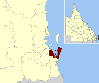
Mount Cotton is a rural locality in the City of Redland, Queensland, Australia. In the 2016 census, Mount Cotton had a population of 6,835 people.

<span class="mw-page-title-main">Redland City</span> Local government area in Queensland, Australia

Redland City, better known as the Redlands and formerly known as Redland Shire, is a local government area and a part of the Brisbane metropolitan area in South East Queensland, Australia. With a population of 159,222 in June 2021, the city is spread along the southern coast of Moreton Bay, covering 537.2 square kilometres (207.4 sq mi). Its mainland borders the City of Brisbane to the west and north-west, and Logan City to the south-west and south, while its islands are situated north of the City of Gold Coast.

<span class="mw-page-title-main">Capalaba, Queensland</span> Suburb of Redland City, Queensland, Australia

Capalaba is an urban locality in the City of Redland, Queensland, Australia. In the 2021 census, Capalaba had a population of 18,002 people.

<span class="mw-page-title-main">Tingalpa, Queensland</span> Suburb of Brisbane, Queensland, Australia

Tingalpa is a suburb in the City of Brisbane, Queensland, Australia. In the 2016 census, Tingalpa had a population of 8,290 people.

<span class="mw-page-title-main">Victoria Point, Queensland</span> Suburb of Redland City, Queensland, Australia

Victoria Point is a coastal locality in Redland City, Queensland, Australia. In the 2021 census, Victoria Point had a population of 15,140 people.

<span class="mw-page-title-main">Carindale, Queensland</span> Suburb of Brisbane, Queensland, Australia

Carindale is a suburb of the City of Brisbane, Queensland, Australia. It is located 13.1 kilometres (8.1 mi) by road south-east of the Brisbane GPO, and borders Belmont, Carina, Carina Heights, Mackenzie, Mansfield, Mount Gravatt East, and Tingalpa. In the 2021 census, Carindale had a population of 16,535 people.

<span class="mw-page-title-main">Cornubia, Queensland</span> Suburb of Logan City, Queensland, Australia

Cornubia is a suburb in the City of Logan, Queensland, Australia. As of the 2021 census, Cornubia had a population of 9,076 people.

<span class="mw-page-title-main">Burbank, Queensland</span> Suburb of Brisbane, Queensland, Australia

Burbank is a greenbelt suburb in the City of Brisbane, Queensland, Australia. In the 2016 census, Burbank had a population of 1,050 people.

<span class="mw-page-title-main">Thornlands, Queensland</span> Suburb of Redland City, Queensland, Australia

Thornlands is a coastal residential locality in the City of Redland, Queensland, Australia. In the 2021 census, Thornlands had a population of 19,263 people.

<span class="mw-page-title-main">Daisy Hill, Queensland</span> Suburb of Logan City, Queensland, Australia

Daisy Hill is a suburb in the City of Logan, Queensland, Australia. In the 2021 census, Daisy Hill had a population of 6,925 people.

<span class="mw-page-title-main">Loganholme, Queensland</span> Suburb of Logan City, Queensland, Australia

Loganholme is a suburb in the City of Logan, Queensland, Australia. In the 2016 census, Loganholme had a population of 6,303 people.

<span class="mw-page-title-main">Thorneside, Queensland</span> Suburb of Redland City, Queensland, Australia

Thorneside is a coastal urban locality in the City of Redland, Queensland, Australia. In the 2016 census, Thorneside had a population of 3,761 people.

<span class="mw-page-title-main">Chandler, Queensland</span> Suburb of Brisbane, Queensland, Australia

Chandler is an outer south-eastern suburb in the City of Brisbane, Queensland, Australia. In the 2016 census, Chandler had a population of 1,442 people.

<span class="mw-page-title-main">Gumdale, Queensland</span> Suburb of Brisbane, Queensland, Australia

Gumdale is an outer suburb of the City of Brisbane, Queensland, Australia. In the 2016 census, Gumdale had a population of 2,118 people.

<span class="mw-page-title-main">Ransome, Queensland</span> Suburb of Brisbane, Queensland, Australia

Ransome is an outer coastal suburb in the City of Brisbane, Queensland, Australia. In the 2016 census, Ransome had a population of 405 people.

<span class="mw-page-title-main">Rochedale, Queensland</span> Suburb of Brisbane, Queensland, Australia

Rochedale ( "roach-dale") is an outer southern suburb in the City of Brisbane, Queensland, Australia. In the 2016 census, Rochedale had a population of 3,175 people.

<span class="mw-page-title-main">Slacks Creek, Queensland</span> Suburb of Logan City, Queensland, Australia

Slacks Creek is a suburb in the City of Logan, Queensland, Australia. In the 2016 census, Slacks Creek had a population of 10,432 people.

<span class="mw-page-title-main">Tingalpa Creek</span> River in Queensland, Australia

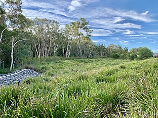
Tingalpa Creek is a creek in South East Queensland. It flows along Brisbane's south east boundary with Redland City Council. On early maps the creek was called both Tunim Creek and Tangulba Creek.

<span class="mw-page-title-main">Mount Cotton Road</span>

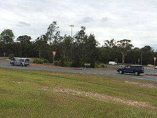
Mount Cotton Road, or Mt Cotton Rd, is a major split road in the Brisbane area of South East Queensland, Australia. It runs in both an east-west direction between Burbank (Brisbane) and Sheldon (Redlands), and a north-south direction between Capalaba (Redlands) and Carbrook (Logan). In total, the road is approximately 26.5 kilometres (16.5 mi) long, and is split at a three-way roundabout.

Cleveland–Redland Bay Road is a continuous 15.2 kilometres (9.4 mi) road route in the Redland local government area of Queensland, Australia. The route is designated as part of State Route 47. It is a state-controlled district road rated as a local road of regional significance (LRRS).

References

  1. 1 2 3 Australian Bureau of Statistics (27 June 2017). "Sheldon (SSC)". 2016 Census QuickStats. Retrieved 20 October 2018. OOjs UI icon edit-ltr-progressive.svg
  2. 1 2 "Sheldon – locality in City of Redland (entry 43633)". Queensland Place Names. Queensland Government . Retrieved 27 January 2020.
  3. 1 2 3 4 5 "Sheldon". Redland City Council. Archived from the original on 28 October 2015. Retrieved 11 September 2015.
  4. 1 2 "Sheldon - Natural Hazards and Critical Infrastructure". Redland City Local Disaster Management Group. Archived from the original on 2 March 2016. Retrieved 11 September 2015.
  5. 1 2 "Mt Cotton and Sheldon timeline". Redland City Council. Archived from the original on 11 April 2015. Retrieved 11 September 2015.
  6. "Sheldon College: Contact Us". Sheldon College. Archived from the original on 15 August 2015. Retrieved 11 September 2015.
  7. Queensland Family History Society (2010), Queensland schools past and present (Version 1.01 ed.), Queensland Family History Society, ISBN   978-1-921171-26-0
  8. 1 2 Australian Bureau of Statistics (31 October 2012). "Sheldon (State Suburb)". 2011 Census QuickStats. Retrieved 11 September 2015. OOjs UI icon edit-ltr-progressive.svg
  9. "ABeeC Hives - Australian Native Bee Hives - Stingless OATH Beehives". ABeeC Hives - Australian Native Bee Hives. Archived from the original on 10 May 2022. Retrieved 11 May 2022.
  10. "State and non-state school details". Queensland Government. 9 July 2018. Archived from the original on 21 November 2018. Retrieved 21 November 2018.
  11. "Sheldon College". Archived from the original on 11 October 2018. Retrieved 21 November 2018.
  12. "ACARA School Profile 2017". Archived from the original on 22 November 2018. Retrieved 22 November 2018.
  13. "Queensland Globe". State of Queensland . Retrieved 1 April 2020.