
Aspley is a suburb in the City of Brisbane, Queensland, Australia. In the 2021 census, Aspley had a population of 12,871 people.

Chermside is a suburb in the City of Brisbane, Queensland, Australia. The suburb is situated 9.8 kilometres (6.1 mi) by road north of the Brisbane CBD. It is home to a large Westfield shopping centre. In the 2021 census, Chermside had a population of 11,426 people.

Bald Hills is the northernmost suburb in the City of Brisbane, Queensland, Australia. In the 2021 census, Bald Hills had a population of 7,000 people.

Gordon Park is a northern suburb in the City of Brisbane, Queensland, Australia. In the 2021 census, Gordon Park had a population of 4,390 people.

Wooloowin is a suburb in the City of Brisbane, Queensland, Australia. In the 2021 census, Wooloowin had a population of 4,029 people.
The Division of Brisbane is an Australian electoral division in the state of Queensland.

Bowen Hills is an inner north-eastern suburb in the City of Brisbane, Queensland, Australia. In the 2021 census, Bowen Hills had a population of 4,898 people.

The South East Busway is a grade separated bus-only road running south from the Brisbane central business district to Eight Mile Plains in Queensland, Australia. The busway was completed to Woolloongabba in September 2000 and to Eight Mile Plains in April 2001. An extension of the busway to School Road at Rochedale was completed in 2014 with no additional busway stations. The maximum capacity of the busway is 18,000 commuters an hour during peak periods. The busway carries an estimated 70 million passengers annually.
The Gympie Arterial Road is a freeway in the northern suburbs of Brisbane in Queensland, Australia. The road starts in Carseldine at Gympie Road and terminates at the Gateway Motorway where it becomes the Bruce Highway. It is three lanes in each direction from Carseldine to the Strathpine Road intersection, and two lanes to the Gateway Motorway.
The Northern Busway is a bus-only road running north from the Brisbane central business district to the Royal Brisbane & Women's Hospital in Queensland, Australia. The first section of the busway opened on 23 February 2004 with one station at QUT Kelvin Grove. In December 2005, Normanby and Herston stations opened.

Lutwyche is a northern suburb in the City of Brisbane, Queensland, Australia. In the 2021 census, Lutwyche had a population of 4,610 people.

Kedron is a northern suburb in the City of Brisbane, Queensland, Australia. It is home to the Queensland Fire and Emergency Services headquarters. In the 2021 census, Kedron had a population of 9,907 people.

Windsor is an inner northern suburb in the City of Brisbane, Queensland, Australia. In the 2021 census, Windsor had a population of 7,811 people.

Carseldine is a suburb in the City of Brisbane, Queensland, Australia. In the 2021 census, Carseldine had a population of 10,093 people.

Kalinga is a suburb in the City of Brisbane, Queensland, Australia. In the 2016 census, Kalinga had a population of 2,126 people.
The M1 in Queensland, Australia, is a major urban road corridor. It connects the Sunshine Coast hinterland to Tugun, near the New South Wales and Queensland border, via the following corridors:

Wilston is a northern suburb in the City of Brisbane, Queensland, Australia. In the 2021 census, Wilston had a population of 4,110 people.
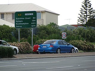
Gympie Road is a major road in the northern suburbs of Brisbane, Queensland, Australia. The road forms part of the main road route from the Brisbane Central Business District (CBD) to the northern suburbs, Sunshine Coast and east coast of Queensland.

The City of Brisbane is a local government area (LGA) which comprises the inner portion of Greater Brisbane, the capital of Queensland, Australia. Its governing body is the Brisbane City Council.
 (M3) Pacific Motorway between Eight Mile Plains and Brisbane CBD
 (A3) Lutwyche Road between Bowen Hills and Kedron