Metroads were the primary road routes serving the Sydney and Brisbane metropolitan areas from the 1990s to the early 2010s. The Metroads formed a network of radial and circumferential routes throughout the cities, simplifying navigation. Metroads have been progressively phased out in both Sydney and Brisbane, replaced by alphanumeric route numbers in Sydney and either alphanumeric or state route markers in Brisbane. Brisbane is the only city currently retaining the Metroad system.
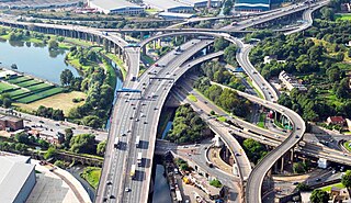
Spaghetti Junction is a nickname sometimes given to a complicated or massively intertwined road traffic interchange that is said to resemble a plate of spaghetti. Such interchanges may incorporate a variety of interchange design elements in order to maximize connectivity.
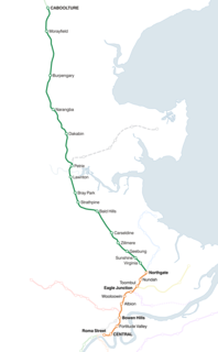
The Caboolture railway line refers to the section of Queensland's North Coast Line that has a regular suburban railway service, extending north of Brisbane, the state capital of Queensland, Australia. The line commences at Roma St station, travelling through the city and extends through Brisbane's northern suburbs to Caboolture, which the line continues north to Sunshine Coast and connects with the Ipswich line south-west of Brisbane. The line distance from Brisbane Central is 49.6 km.
Transurban is a road operator company that manages and develops urban toll road networks in Australia, Canada and the United States. It was founded in 1999 and is listed on the Australian Securities Exchange (ASX).

Woolloongabba is a suburb of the City of Brisbane, Queensland, Australia. It is located 2 kilometres (1.2 mi) south-east of the CBD, and contains the Brisbane Cricket Ground and the Princess Alexandra Hospital. It is crossed by several major roads including the Pacific Motorway. The suburb was once home to a large tram depot.
The Gateway Motorway is a major tolled motorway in Brisbane, Queensland, Australia which includes the Sir Leo Hielscher Bridges. The motorway is operated by toll road operator Transurban.

The M7 runs from the junction of Ipswich Road and Granard Road to the M2 Logan Motorway interchange. It is then signed M2 until the junction of the Warrego Highway and the Cunningham Highway between Brisbane and Ipswich in South East Queensland, Australia.

Rocklea is a suburb in the City of Brisbane, Queensland, Australia. In the 2016 census, Rocklea had a population of 1,595 people.
TransApex is a road transport plan devised by Brisbane Lord Mayor Campbell Newman in the early 2000s to connect existing motorways and major arterial roads with new transport links and divert cross-city traffic out of the Brisbane CBD. The plan is currently being delivered by Brisbane City Council at an estimated total cost of over $10 billion across five stages. According to the Brisbane City Council website, TransApex is "the biggest urban road project proposed in Australia".

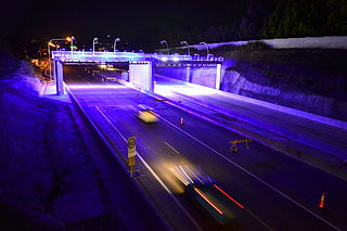
The M7 Clem Jones Tunnel (CLEM7), known during its development as the North-South Bypass Tunnel (NSBT), is a A$3.2 billion motorway grade toll road under the Brisbane River, between Woolloongabba and Bowen Hills in Brisbane, Queensland. The tunnel was progressively opened to traffic from late on 15 March 2010 until just after midnight on 16 March 2010. It was completely open by 12:02 am.

The Airport Link is a tunnelled, motorway grade, toll road in the northern suburbs of Brisbane, Queensland, Australia. It connects the Brisbane central business district and the Clem Jones Tunnel to the East-West Arterial Road which leads to the Brisbane Airport. It was built in conjunction with the Windsor to Kedron section of the Northern Busway in approximately the same corridor.
The Hills Motorway is a tollway in north-western Sydney, Australia, owned by toll road operator Transurban. It forms majority of Sydney's M2 route and part of the 110 km Sydney Orbital Network, with Lane Cove Tunnel constituting the rest of the M2 route. The M2 is also part of the National Highway west of Pennant Hills Road. It was known as the North West Transport Link during planning in the early 1990s.
The (M2) in Brisbane, Queensland, Australia, is a major motorway route and southern bypass of Brisbane. It connects the Warrego Highway (A2) at Brassall to the (M1) at Eight Mile Plains via the following corridors:
The (M3/A3) in Brisbane, Queensland, Australia, is a major urban road corridor. It connects Eight Mile Plains to Bald Hills via the following corridors:
The M1 in, Queensland, Australia, is a major urban road corridor. It connects the Sunshine Coast hinterland to Tugun, near the New South Wales-Queensland border, via the following corridors:

Logan Road, allocated state routes 95 and 30, is a major road in Brisbane, Queensland. It runs 18 kilometres (11 mi) from Springwood in Logan City to Woolloongabba in Brisbane, with most of the route signed as state route 95. The route was formerly the main route to the Gold Coast from Brisbane, until the South East Freeway was built.

Ipswich Road is one Brisbane's main roads connecting Brisbane to the nearby city of Ipswich, via the Ipswich Motorway. Ipswich Road used to be part of the Cunningham Highway. Logan Road, Pacific Motorway, and Beaudesert Road are the other major roads in the south of Brisbane. The road was an important transport route in 19th century Brisbane.

The road transport of Brisbane, Australia consists of a network of highways, freeways and motorways. Some motorways have tolls applied.
This is a list of freeways or freeway grade roads. in Australia, sorted by states and territories and their corresponding routes. This list includes tollways / toll roads such as the CityLink freeway system in Melbourne. This list has over 120 entries. The jurisdiction in Australia without freeways is the Northern Territory and Jervis Bay Territory. New South Wales has the largest and densest freeway network in Australia followed by Victoria and then Queensland
The Linkt network is a 70 kilometre integrated network of tolled roads, bridges and tunnels across the greater Brisbane area. Linkt has one million tolling accounts and more than 1.8 million Linkt tags in use as of 2013.
This page is based on this
Wikipedia article Text is available under the
CC BY-SA 4.0 license; additional terms may apply.
Images, videos and audio are available under their respective licenses.


