
Cairns is a city in the Cairns Region, Queensland, Australia, on the tropical north east coast of Far North Queensland. In the 2021 census, Cairns had a population of 153,181 people.

Stratford is a town located in Queens County, Prince Edward Island.

The Historic Columbia River Highway is an approximately 75-mile-long (121 km) scenic highway in the U.S. state of Oregon between Troutdale and The Dalles, built through the Columbia River Gorge between 1913 and 1922. As the first planned scenic roadway in the United States, it has been recognized in numerous ways, including being listed on the National Register of Historic Places, being designated as a National Historic Landmark by the U.S. Secretary of the Interior, being designated as a National Historic Civil Engineering Landmark by the American Society of Civil Engineers, and being considered a "destination unto itself" as an All-American Road by the U.S. Secretary of Transportation. The historic roadway was bypassed by the present Columbia River Highway No. 2 from the 1930s to the 1950s, leaving behind the old two-lane road. The road is now mostly owned and maintained by the state through the Oregon Department of Transportation as the Historic Columbia River Highway No. 100 or the Oregon Parks and Recreation Department as the Historic Columbia River Highway State Trail.

The Atherton Tableland is a fertile plateau, which is part of the Great Dividing Range in Queensland, Australia. It has very deep, rich basaltic soils and the main industry is agriculture. The principal river flowing across the plateau is the Barron River, which was dammed to form the irrigation reservoir named Lake Tinaroo. Unlike many other rural areas, the Tablelands is experiencing a significant growth in population.

Barwon Heads is a coastal township on the Bellarine Peninsula, near Geelong, Victoria, Australia. It is situated on the west bank of the mouth of the Barwon River below Lake Connewarre, while it is bounded to the west by farmland, golf courses and the saline ephemeral wetland of Murtnaghurt Lagoon. At the 2016 census, Barwon Heads had a population of 3,875.

Kuranda is a rural town and locality on the Atherton Tableland in the Shire of Mareeba, Queensland, Australia. It is 25 kilometres (16 mi) from Cairns, via the Kuranda Range road. It is surrounded by tropical rainforest and adjacent to the Wet Tropics of Queensland World Heritage listed Barron Gorge National Park. In the 2021 census, the locality of Kuranda had a population of 3,273 people.

The Barron River is located on the Atherton Tablelands inland from Cairns in North Queensland, Australia. With its headwaters below Mount Hypipamee, the 165-kilometre (103 mi)-long river with a catchment area of approximately 2,138 square kilometres (825 sq mi) forms through run off from the Mount Hypipamee National Park, flows through Lake Tinaroo, and eventually empties into the Coral Sea between Machans Beach and Aeroglen.
King's Highway 8, commonly referred to as Highway 8, is a provincially maintained highway in the Canadian province of Ontario. The 159.7-kilometre (99.2 mi) route travels from Highway 21 in Goderich, on the shores of Lake Huron, to Highway 5 in the outskirts of Hamilton near Lake Ontario. Before the 1970s, it continued east through Hamilton and along the edge of the Niagara Escarpment to the American border at the Whirlpool Bridge in Niagara Falls. However, the Queen Elizabeth Way (QEW) replaced the role of Highway 8 between those two cities, and the highway was subsequently transferred from the province to the newly formed Regional Municipality of Niagara in 1970. In 1998, the remaining portion east of Peters Corners was transferred to the city of Hamilton.

Smithfield is a suburb of Cairns in the Cairns Region, Queensland, Australia. In the 2021 census, Smithfield had a population of 6,664 people.

The Hillsborough River Bridge is a bridge crossing the Hillsborough River estuary between Charlottetown and Stratford in Queens County, Prince Edward Island. The current road bridge, built in 1962, replaced a 1905 rail bridge crossing the same span which was known by the same name.
Holloways Beach is a northern coastal suburb of Cairns, Queensland, Australia. It is located about 10 kilometres north of the city of Cairns between the suburbs of Machans Beach and Yorkeys Knob. In the 2021 census, Holloways Beach had a population of 2,398 people.

Freshwater is a suburb of Cairns, Queensland, Australia. In the 2021 census, Freshwater had a population of 2,142 people.

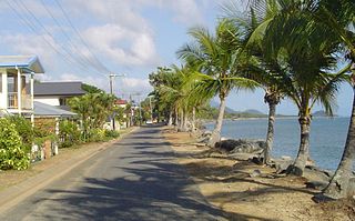
Stratford is a suburb of Cairns in the Cairns Region, Queensland, Australia. In the 2021 census, Stratford had a population of 1,198 people.

Cooktown is a coastal town and locality in the Shire of Cook, Queensland, Australia. Cooktown is at the mouth of the Endeavour River, on Cape York Peninsula in Far North Queensland where James Cook beached his ship, the Endeavour, for repairs in 1770. Both the town and Mount Cook which rises up behind the town were named after James Cook.

Aeroglen is a coastal suburb of Cairns in the Cairns Region, Queensland, Australia. It is approximately 5 kilometers north of the Cairns City centre. In the 2021 census, Aeroglen had a population of 405 people.
Sunnyside is a neighbourhood of South Surrey, which in turn is a region of Surrey, British Columbia, Canada.
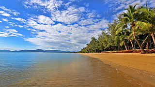
Machans Beach is a beach and coastal suburb of Cairns in the Cairns Region, Queensland, Australia. In the 2021 census, Machans Beach had a population of 943 people.

Barron is a suburb of Cairns in the Cairns Region, Queensland, Australia. In the 2021 census, Barron had a population of 68 people.

Freshwater railway station is on the Cairns-to-Kuranda railway line in Queensland, Australia. It is located at Kamerunga Road, Barron in Cairns.
Redden Island known as "Dungarra" to the original inhabitants is an Island in Far North Queensland part of the Suburb or Machans Beach, Queensland. It is an important habitat for bird life Including some rare and endangered species. Made up of bushland, mangroves and a beach there are than 200 bird species recorded. It is also a historical landmark in Queensland.

