Roads of Strategic Importance (ROSI) is a $5.8 billion initiative of the Australian Government designed to help connect regional businesses to local and international markets, and to better connect regional communities. The source for this article is an Australian Government website titled "Roads of Strategic Importance". [1] Funding by the Australian Government is up to 80% of total costs, with the remainder being met by state, territory and local governments. ROSI reserves $1.5 billion for projects in Northern Australia, building on the benefits being delivered by the Northern Australia Roads Program and the Northern Australia Beef Roads Program. [2]
ROSI is ensuring that key freight roads efficiently connect agricultural and mining regions to ports, airports and other transport hubs. The work undertaken includes bridge and culvert construction, road widening, sealing, overtaking lanes and pavement renewal.
Most ROSI projects are grouped within defined corridors, which are listed separately in alphabetic sequence for each of Northern and Southern Australia. A corridor includes roads and related infrastructure associated with the efficient operation of the principal highway or road in the corridor. Each corridor listed contains zero to many projects, some of which pertain to a single road while others cover multiple roads and/or related infrastructure.
For each corridor or project in the source document with a link indicator (underline) there is a linked Project Description web page or PDF document. The project description shows some or all of the following details:
One named corridor has no associated projects, and several named projects have no linked Project Description. This article will be updated when further details become available.
NOTE: Refer to the Talk page for information on updating this section.
Details of the following projects have been copied to relevant Wikipedia articles:
Known ROSI projects not identified in the source document are listed below:

The National Highway is a system of roads connecting all mainland states and territories of Australia, and is the major network of highways and motorways connecting Australia's capital cities and major regional centres.

Highways in Australia are generally high capacity roads managed by state and territory government agencies, though Australia's federal government contributes funding for important links between capital cities and major regional centres. Prior to European settlement, the earliest needs for trade and travel were met by narrow bush tracks, used by tribes of Indigenous Australians. The formal construction of roads began in 1788, after the founding of the colony of New South Wales, and a network of three major roads across the colony emerged by the 1820s. Similar road networks were established in the other colonies of Australia. Road construction programs in the early 19th century were generally underfunded, as they were dependent on government budgets, loans, and tolls; while there was a huge increase in road usage, due to the Australian gold rushes. Local government authorities, often known as Road Boards, were therefore established to be primarily responsible for funding and undertaking road construction and maintenance. The early 1900s saw both the increasingly widespread use of motorised transportation, and the creation of state road authorities in each state, between 1913 and 1926. These authorities managed each state's road network, with the main arterial roads controlled and maintained by the state, and other roads remaining the responsibility of local governments. The federal government became involved in road funding in the 1920s, distributing funding to the states. The depression of the 1930s slowed the funding and development of the major road network until the onset on World War II. Supply roads leading to the north of the country were considered vital, resulting in the construction of Barkly, Stuart, and Eyre Highways.

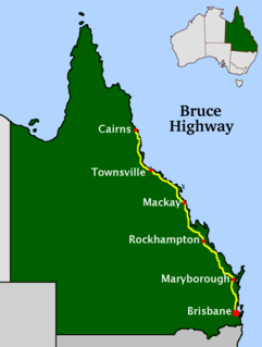
The Bruce Highway is a major highway in Queensland, Australia. Commencing in the state capital, Brisbane, it passes through areas close to the eastern coast on its way to Cairns in Far North Queensland. The route is part of the Australian National Highway and also part of Highway 1, the longest highway route in Australia. Its length is approximately 1,679 kilometres (1,043 mi); it is entirely sealed with bitumen. The highway is named after a popular former Queensland and federal politician, Harry Bruce. Bruce was the state Minister for Works in the mid-1930s when the highway was named after him. The highway once passed through Brisbane, but was truncated at Bald Hills when the Gateway Motorway became National Highway 1 upon its opening in December 1986.

The Capricorn Highway is located in Central Queensland, Australia, and links the city of Rockhampton with western Queensland. The highway is 575 kilometres long, and joins the Landsborough Highway at Barcaldine. Formerly National Route 66, Queensland began to convert to the alphanumeric system much of Australia had adopted in the early-2000s and is now designated as A4. The highway runs parallel with the Tropic of Capricorn, hence its name.

The North Coast railway line is a 1,681-kilometre (1,045 mi) 3-foot 6-inch gauge railway line in Queensland, Australia. It commences at Roma Street station, Brisbane, and largely parallels the Queensland coast to Cairns in Far North Queensland. The line is electrified between Brisbane and Rockhampton. Along the way, the 1680 km railway passes through the numerous towns and cities of eastern Queensland including Nambour, Bundaberg, Gladstone, Rockhampton, Mackay and Townsville. The line though the centre of Rockhampton runs down the middle of Denison Street.

The Regions of Queensland refer to the geographic areas of the Australian state of Queensland. Due to its large size and decentralised population, the state is often divided into regions for statistical and administrative purposes. Each region varies somewhat in terms of its economy, population, climate, geography, flora and fauna. Cultural and official perceptions and definitions of the various regions differ somewhat depending on the government agency or popular group by which they are being applied.

Greyhound Australia is an Australian coach operator that ran services in all mainland states and territories until reduction of services in the 2000s.

The rail network in Queensland, Australia, was the first in the world to adopt 1,067 mm narrow gauge for a main line, and now the second largest narrow gauge network in the world, consists of:
This article is about Transport in Townsville, Queensland.

The Roman Catholic Archdiocese of Brisbane is a Latin Church metropolitan archdiocese of the Catholic Church in Australia located in Brisbane and covering the South East region of Queensland, Australia.
Peter Alexander Byrne is an Australian television presenter and meteorologist. Byrne was most notable for being a weather presenter for WIN Television from 1990 until 2012.

Queensland's railway construction commenced in 1864, with the turning of the first sod of the Main Line by Lady Diamantina Bowen, the wife of Queensland's first governor Sir George Bowen at Ipswich, Queensland, Australia. A narrow gauge of 3 ft 6 in was selected due to cost savings in providing a rail link to Toowoomba. Despite being built with bridges wide enough for standard gauge, and the fact that most other lines did not require heavy earthworks, the gauge remained the Queensland system norm.

The Hughenden-Winton railway line was a railway line in Queensland, Australia, branching from the Mt Isa line at Hughenden and connecting to the Central West line at Winton.

State Strategic Touring Routes (SSTR) are road routes in Queensland, Australia, which have been identified as significant to motoring tourists. These are the primary routes used by tourists as they provide the connections between popular tourist locations, and consequently have high volumes of tourist traffic. Standardised road signage is used to identify the route itself, with "Welcome to" signage at towns and districts of interest to tourists, as well as "turn off" signage to natural attractions.
The Pacific Coast Way is an Australian road route from Sydney, New South Wales to Cairns in Queensland. It has been designated by the Queensland Government as a State Strategic Touring Route.
The Scenic Highway is a coastal highway from Yeppoon to Emu Park, both on the Capricorn Coast in the Shire of Livingstone, Queensland, Australia.
Northern Australia Beef Roads Program is a suite of projects designed to deliver targeted upgrades to key roads for transporting cattle in northern Australia. In 2016 the Australian Government announced 18 projects to be funded under this program. This program is separate to the Northern Australia Roads Program, also announced in 2016, which contains a further 20 projects.
Ootann Road is a continuous 90.5 kilometres (56.2 mi) road route in the Mareeba and Tablelands local government areas of Queensland, Australia. It is a north-south link between the Burke Developmental Road and the Kennedy Highway, servicing a number of cattle grazing and production areas in northern Queensland. It is also part of the shortest route from the Chillagoe area to Hughenden.
Rockhampton–Yeppoon Road is a non-continuous 39.8 kilometres (24.7 mi) road route in the Rockhampton and Livingstone local government areas of Queensland, Australia. Most of the route is designated as State Route 4 (Regional) and Tourist Drive 10. It is a state-controlled regional road.