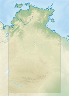
Litchfield National Park, covering approximately 1500 km2, is near the township of Batchelor, 100 km south-west of Darwin, in the Northern Territory of Australia. Each year the park attracts over 260,000 visitors.
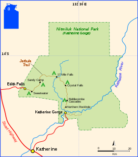
Nitmiluk National Park is in the Northern Territory of Australia, 244 km southeast of Darwin, around a series of gorges on the Katherine River and Edith Falls. Previously named Katherine Gorge National Park, its northern edge borders Kakadu National Park. The gorges and the surrounding landscape have great ceremonial significance to the local Jawoyn people, who are custodians of Nitmiluk National Park. In Jawoyn, Nitmiluk means "place of the cicada dreaming".

The Springbrook National Park is a protected national park that is located in the Gold Coast hinterland of Queensland, Australia. The 6,197-hectare (15,310-acre) park is situated on the McPherson Range, near Springbrook, approximately 100 kilometres (62 mi) south of Brisbane. The park is part of the Shield Volcano Group of the UNESCO World Heritage–listed Gondwana Rainforests of Australia.

Katherine is a town in the Northern Territory of Australia. It is situated on the Katherine River below the "Top End", 320 kilometres (200 mi) southeast of Darwin. It is the fourth largest settlement in the Territory and is known as the place where "The outback meets the tropics". Katherine had an urban population of approximately 6,300 at the 2016 Census. Katherine is also the closest major town to RAAF Base Tindal located 17 km southeast and provides education, health, local government services and employment opportunities for the families of Defence personnel stationed there. In the 2016 census, the base had a residential population of 857, with only around 20% of the workforce engaged in employment outside of defence, the majority commuting to work in Katherine. Katherine is also the central hub of the great "Savannah Way" which stretches from Cairns in north QLD to Broome in the Kimberley WA.
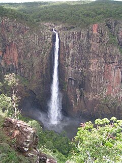
The Wallaman Falls, a cascade and horsetail waterfall on the Stony Creek, is located in the UNESCO World Heritage–listed Wet Tropics in the northern region of Queensland, Australia. The waterfall is notable for its main drop of 268 metres (879 ft), which makes it the country's tallest single-drop waterfall. The pool at the bottom of the waterfall is 20 metres (66 ft) deep. An estimated 100,000 people visit the waterfall annually.
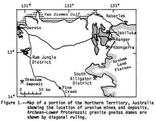
Alligator Rivers is the name of an area in an Arnhem Land region of the Northern Territory of Australia, containing three rivers, the East, West, and South Alligator Rivers. It is regarded as one of the richest biological regions in Australia, with part of the region in the Kakadu National Park. It is an Important Bird Area (IBA), lying to the east of the Adelaide and Mary River Floodplains IBA. It also contains mineral deposits, especially uranium, and the Ranger Uranium Mine is located there. The area is also rich in Australian Aboriginal art, with 1500 sites. The Kakadu National Park is one of the few World Heritage sites on the list because of both its natural and human heritage values. They were explored by Lieutenant Phillip Parker King in 1820, who named them in the mistaken belief that the crocodiles in the estuaries were alligators.

Jabiru is a town in the Northern Territory of Australia. It was originally built in 1982 as a closed town to house the community living at Jabiru East near the Ranger Uranium Mine eight kilometres away. Both the mine and the town are completely surrounded by Kakadu National Park. At the 2006 census, Jabiru had a population of 1,135.

The Twin Falls is a cascade waterfall on the South Alligator River that descends over the Arnhem Land escarpment within the UNESCO World Heritage–listed Kakadu National Park in the Northern Territory of Australia. In 1980, The Twin Falls area was listed on the now-defunct Register of the National Estate.

The Wangi Falls is a segmented waterfall on the Wangi Creek located within the Litchfield National Park in the Northern Territory of Australia.

The Florence Falls is a segmented waterfall on the Florence Creek located within the Litchfield National Park in the Northern Territory of Australia.

The Tjaynera Falls is a waterfall on the Sandy Creek that is located within the Litchfield National Park in the Northern Territory of Australia.

The Tolmer Falls is a plunge waterfall on the Tolmer Creek that is located in the Litchfield National Park in the Northern Territory of Australia.
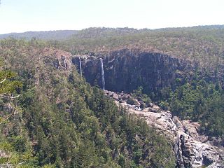
The Blencoe Falls is a segmented waterfall on the Blencoe Creek, located in the Far North region of Queensland, Australia.
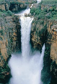
The Jim Jim Falls is a plunge waterfall on the Jim Jim Creek that descends over the Arnhem Land escarpment within the UNESCO World Heritage–listed Kakadu National Park in the Northern Territory of Australia. The Jim Jim Falls area is registered on the Australian National Heritage List.

The Edith Falls is a series of cascading waterfalls and pools on the Edith River in the Nitmiluk National Park, located approximately 60 kilometres (37 mi) north of Katherine, in the Northern Territory of Australia.

The Belmore Falls is a plunge waterfall with three drops on the Barrengarry Creek in the Southern Highlands and Illawarra regions of New South Wales, Australia.

The Wildman River is a river in the Darwin Coastal bioregion of the Northern Territory, Australia.


