
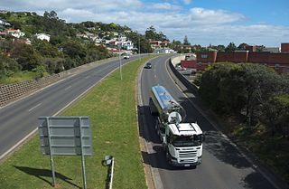
The Midland Highway is one of Tasmania's major inter-city highways, running for 176 kilometres (109 mi) between Hobart and Launceston. It is part of the AusLink National Network and is a vital link for road freight to transport goods to and from the two cities. It represents a major north–south transportation corridor in Tasmania and has the route 1 designation as part of the National Highway. The highway consists of various traffic lane arrangements, the most common being two lanes – one in each direction, with overtaking options and at-grade intersections. At both the Launceston and Hobart sections of the highway there are small portions of grade-separated dual carriageway.

Deloraine is a town on the Meander River, in the central north of Tasmania, Australia. It is 50 km west of Launceston and 52 km south of Devonport along the Bass Highway. It is part of the Meander Valley Council. Deloraine recorded a population of 3,035 in the 2021 census. Deloraine, like most Tasmanian towns, has a temperate and wet climate.
The Bass Highway is a highway in Tasmania, Australia. It connects the three cities across the north of the state – Burnie, Devonport and Launceston. The road was named due to its proximity to the Bass Strait. It is a part of the National Highway, designated as National Highway 1, together with the Midland and Brooker highways in Tasmania.

The N1 is a national route in South Africa that runs from Cape Town through Bloemfontein, Johannesburg, Pretoria and Polokwane to Beit Bridge on the border with Zimbabwe. It forms the first section of the famed Cape to Cairo Road.

Great Northern Highway is an Australian highway that links Western Australia's capital city Perth with its northernmost port, Wyndham. With a length of almost 3,200 kilometres (2,000 mi), it is the longest highway in Australia, with the majority included as part of the Perth Darwin National Highway. The highway, which travels through remote areas of the state, is constructed as a sealed, predominantly two-lane single carriageway, but with some single-lane bridges in the Kimberley. Economically, it provides vital access through the Wheatbelt and Mid West to the resource-rich regions of the Pilbara and Kimberley. In these areas, the key industries of mining, agriculture and pastoral stations, and tourism are all dependent on the highway.

Great Eastern Highway is a 590-kilometre-long (370 mi) road that links the Western Australian capital of Perth with the city of Kalgoorlie. A key route for road vehicles accessing the eastern Wheatbelt and the Goldfields, it is the western portion of the main road link between Perth and the eastern states of Australia. The highway forms the majority of National Highway 94, although the alignment through the Perth suburbs of Guildford and Midland, and the eastern section between Coolgardie and Kalgoorlie are not included. Various segments form parts of other road routes, including National Route 1, Alternative National Route 94, and State Route 51.
King's Highway 27, commonly referred to as Highway 27, is a provincially maintained highway in the Canadian province of Ontario. The Ministry of Transportation of Ontario was once responsible for the length of the route, when it ran from Long Branch to Highway 93 in Waverley. Highway 27 followed a mostly straight route throughout its length, as it passed through the suburbs of Toronto, then north of Kleinburg the vast majority of the highway was surrounded by rural farmland. Today, only the southernmost 1.6 km (1 mi) from Highway 427 north to Mimico Creek is under provincial jurisdiction, the remainder of the route is maintained by the city of Toronto, York Region and Simcoe County.
Summerhill is a residential locality in the local government areas (LGA) of Launceston (96%) and Meander Valley (4%) in the Launceston LGA region of Tasmania. The locality is about 6 kilometres (3.7 mi) south of the town of Launceston. The 2016 census recorded a population of 3135 for the state suburb of Summerhill. It is a suburb of Launceston.
Alberta Provincial Highway No. 1A is the designation of two alternate routes off the Alberta portion of Trans-Canada Highway 1. However, it is not the only name used for spurs off Highway 1 - Highway 1X is another such designation. Despite these highways being suffixed routes of Highway 1, they are not part of the Trans-Canada Highway network, and are signed with Alberta's provincial primary highway shields instead of the Trans-Canada shields used for Highway 1.

Great Eastern Highway Bypass is a limited-access dual carriageway linking Great Eastern Highway and Roe Highway in Perth, Western Australia. Together with a section of Roe Highway, it bypasses the historical Guildford and Midland localities, through which the original, urban and slower Great Eastern Highway passes.
Blackstone Heights is a rural/residential locality in the local government areas (LGA) of Meander Valley (97.5%) and West Tamar (2.5%) in the Launceston LGA region of Tasmania. The locality is about 34 kilometres (21 mi) east of the town of Westbury. The 2016 census recorded a population of 1270 for the state suburb of Blackstone Heights. It is an outer suburb of Launceston.

Hadspen is a town on the South Esk River in the north of Tasmania, Australia, 8 kilometres (5.0 mi) south west of Launceston. Hadspen has few commercial establishments and is primarily a residential suburb of nearby Launceston. Most of the town's buildings are residential, and relatively recent. The town's population of just over 2000 has grown rapidly from only a few hundred in the 1960s, and there are development plans that call for its doubling.

Riverside is a rural and urban locality in the local government areas of Meander Valley and West Tamar in the Launceston region of Tasmania, Australia. The locality is about 39 kilometres (24 mi) south-east of the town of Beaconsfield. The 2016 census has a population of 6472 for the state suburb of Riverside. It is a residential suburb 5 kilometres (2.5 mi) north-west of the central business district of Launceston, Tasmania's second largest city. The West Tamar Highway runs through the suburb, adjoining Riverside to the West Tamar, which includes small towns: Beaconsfield, and Beauty Point. Riverside is part of the West Tamar Council local government area. The suburb is now Launceston's largest by population, narrowly ahead of Kings Meadows. The main shopping centre opened in the 1960s and includes: a Woolworths supermarket, a bakery, a pharmacist and several retail shops.
Prospect Vale is a rural/residential locality in the local government areas (LGA) of Launceston (1%) and Meander Valley (99%) in the Launceston LGA region of Tasmania. The locality is about 7 kilometres (4.3 mi) south-west of the town of Launceston. The 2016 census recorded a population of 5067 for the state suburb of Prospect Vale. It is a small suburb of Greater Launceston. Prospect Vale has a small shopping centre, Prospect Vale Marketplace, containing a Woolworths supermarket and a small industrial park lies within its boundaries. Sporting grounds include the St Patrick's Old Collegians Football Club Oval, who compete in the Northern Tasmania Football Association.
Travellers Rest is a rural/residential locality in the local government areas (LGA) of Meander Valley (98%) and Northern Midlands (2%) in the Launceston and Central LGA regions of Tasmania. The locality is about 24 kilometres (15 mi) east of the town of Westbury. The 2016 census recorded a population of 305 for the state suburb of Travellers Rest. It is a settled semi-rural area at the edge of Greater Launceston.

In Tasmania, Highway 1 is a 336-kilometre (209 mi) long route that connects Hobart to the state's north coast, and to Launceston via a 3.8-kilometre (2.4 mi) long spur. Highway 1 also exists on the mainland of Australia, linking the state capitals via a circular route around the coastline. All roads within the Highway 1 system are allocated a road route numbered 1, M1, A1, or B1, depending on the state route numbering system. In Tasmania the highway is designated as National Highway 1, though all other routes in the state are alphanumeric.

Hagley is a rural locality and town in the local government area of Meander Valley in the Launceston region of Tasmania. The locality is about 5 kilometres (3.1 mi) north-east of the town of Westbury. The 2016 census has a population of 335 for the state suburb of Hagley.
Red Hills is a locality and suburb in the local government area of Meander Valley, in the Launceston region of Tasmania. It is located about 7 kilometres (4.3 mi) west of the town of Deloraine. The Meander River forms part of the south-eastern boundary, while its tributary Western Creek forms the remainder. The railway tracks of the Western line pass through the north-eastern corner of the locality, crossing the B12 route at Lemana Junction. The 2016 census determined a population of 120 for the state suburb of Red Hills.
Reedy Marsh is a rural locality in the local government area (LGA) of Meander Valley in the Launceston LGA region of Tasmania. It is about 23 kilometres (14 mi) northwest of the town of Westbury. Its population was 185 at the 2016 census.
