Councils of Tasmania are the 29 administrative districts of the Australian state of Tasmania. Local government areas (LGAs), more generally known as councils, are the tier of government responsible for the management of local duties such as road maintenance, town planning and waste management.
Dorset Council is a local government body in Tasmania, located in the far north-east of the state mainland. Dorset is classified as a rural local government area and has a population of 6,652, the major towns and localities of the region include Bridport, Derby and Ringarooma with Scottsdale the regional centre.

Ben Lomond is a mountain in the north-east of Tasmania, Australia.
The Mount Jukes Mine sites were a series of short-lived, small mine workings high on the upper regions of Mount Jukes in the West Coast Range on the West Coast of Tasmania.

The Pipers River is a perennial river located in northern region of Tasmania, Australia. It was named for Captain Hugh Piper. The Aboriginal name for the river is Wattra karoola.
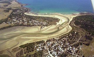
Bellingham is a rural locality in the local government area (LGA) of George Town in the Launceston LGA region of Tasmania. The locality is about 39 kilometres (24 mi) north-east of the town of George Town. The 2016 census has a population of 60 for the state suburb of Bellingham. It is a tiny coastal hamlet in northern Tasmania, situated on the mouth of the Pipers River directly opposite the town of Weymouth. The town is located 62 kilometres (39 mi) from Launceston, 20 kilometres (12 mi) from Bridport and 38 kilometres (24 mi) from George Town.
Weymouth is a rural locality in the local government area (LGA) of George Town in the Launceston LGA region of Tasmania. The locality is about 37 kilometres (23 mi) north-east of the town of George Town. The 2016 census has a population of 129 for the state suburb of Weymouth. It is a small township in northern Tasmania, on the Pipers River opposite Bellingham and about 60 km from Launceston. It has a very small permanent population; however, it attracts many visitors during the summer months. Weymouth has a beach, a tennis court, and a community hall with a playground.
Underwood is a rural locality and town in the local government area of Launceston, in the Northern region of Tasmania. It is located about 22 kilometres (14 mi) north-east of the city of Launceston. The 2016 census determined a population of 363 for the state suburb of Underwood.

Launceston City Council is a local government body in Tasmania, located in the city and surrounds of Launceston in the north of the state. The Launceston local government area is classified as urban and has a population of 67,449, which also encompasses the localities including Lilydale, Targa and through to Swan Bay on the eastern side of the Tamar River.

Mathinna is a rural locality in the local government areas (LGA) of Break O'Day (97%) and Dorset (3%) in the North-east LGA region of Tasmania. The locality is about 83 kilometres (52 mi) south-west of the town of St Helens. The 2016 census recorded a population of 142 for the state suburb of Mathinna.
Pipers River is a rural residential locality in the local government areas (LGA) of George Town (98%) and Launceston (2%) in the Launceston LGA region of Tasmania. The locality is about 23 kilometres (14 mi) east of the town of George Town. The 2016 census recorded a population of 426 for the state suburb of Pipers River. It is a small township on the river of the same name in the north of Tasmania.
Rocherlea is a residential locality in the local government area (LGA) of Launceston in the Launceston LGA region of Tasmania. The locality is about 9 kilometres (5.6 mi) north of the town of Launceston. The 2016 census recorded a population of 1081 for the state suburb of Rocherlea. It is a northern suburb of Launceston, about ten minutes drive from the Launceston CBD and on the way to Lilydale. It has a community centre, church and op shop.
Conara is a rural locality in the local government area (LGA) of Northern Midlands in the Central LGA region of Tasmania. The locality is about 50 kilometres (31 mi) south-east of the town of Longford. The 2016 census recorded a population of 130 for the state suburb of Conara.

Hagley is a rural locality and town in the local government area of Meander Valley in the Launceston region of Tasmania. The locality is about 5 kilometres (3.1 mi) north-east of the town of Westbury. The 2016 census has a population of 335 for the state suburb of Hagley.
Exton is a rural locality in the local government area of Meander Valley in the Launceston region of Tasmania. The locality is about 10 kilometres (6.2 mi) west of the town of Westbury. It lies on the outskirts of Deloraine, that lies next to the railway line from Launceston to Devonport. Its population was estimated at 200 in 1932, and the 2011 census reported the area of Reedy Marsh, which incorporated Exton, had a population of 309 people. The 2016 census has a population of 154 for the state suburb of Exton.
Karoola is a rural locality and town in the local government area of Launceston, in the Northern region of Tasmania. It is located about 26 kilometres (16 mi) north of the city of Launceston. The 2016 census determined a population of 318 for the state suburb of Karoola.
Pipers Brook is a rural locality in the local government areas of Launceston, Dorset and George Town in the Launceston and North-east regions of Tasmania. It is located about 33 kilometres (21 mi) east of the town of George Town. The 2016 census determined a population of 93 for the state suburb of Pipers Brook.
Lower Turners Marsh is a rural locality in the local government areas of Launceston and George Town in the Launceston and North-east regions of Tasmania. It is located about 34 kilometres (21 mi) south-east of the town of George Town. The 2016 census determined a population of 37 for the state suburb of Lower Turners Marsh.
North Lilydale is a rural locality in the local government areas (LGA) of Dorset and Launceston in the North-east and Launceston LGA regions of Tasmania. The locality is about 33 kilometres (21 mi) west of the town of Scottsdale. The 2016 census recorded a population of 82 for the state suburb of North Lilydale.
Turners Marsh is a rural locality in the local government area (LGA) of Launceston in the Launceston LGA region of Tasmania. The locality is about 19 kilometres (12 mi) north of the town of Launceston. The 2016 census recorded a population of 254 for the state suburb of Turners Marsh.


