Firth is a word in the English and Scots languages used to denote various coastal waters in the United Kingdom, predominantly within Scotland. In the Northern Isles, it more often refers to a smaller inlet. It is linguistically cognate to Scandinavian fjord and fjard, with the original meaning of "sailable waterway". The word has a more constrained sense in English. Bodies of water named "firths" tend to be more common on the Scottish east coast, or in the southwest of the country, although the Firth of Clyde is an exception to this. The Highland coast contains numerous estuaries, straits, and inlets of a similar kind, but not called "firth" ; instead, these are often called sea lochs. Before about 1850, the spelling "Frith" was more common.

The River Avon is a river in the Strathspey area of the Scottish Highlands, and a tributary of the River Spey. It drains the north-eastern area of the Cairngorm Mountains and is largely contained within the Cairngorms National Park

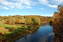
The River Tay is the longest river in Scotland and the seventh-longest in Great Britain. The Tay originates in western Scotland on the slopes of Ben Lui, then flows easterly across the Highlands, through Loch Dochart, Loch Iubhair and Loch Tay, then continues east through Strathtay, in the centre of Scotland, then southeasterly through Perth, where it becomes tidal, to its mouth at the Firth of Tay, south of Dundee. It is the largest river in the United Kingdom by measured discharge. Its catchment is approximately 2,000 square miles, the Tweed's is 1,500 sq mi (3,900 km2) and the Spey's is 1,097 sq mi (2,840 km2).

The Caledonian Canal connects the Scottish east coast at Inverness with the west coast at Corpach near Fort William in Scotland. The canal was constructed in the early nineteenth century by Scottish engineer Thomas Telford.

The Great Glen, also known as Glen Albyn or Glen More, is a glen in Scotland running for 62 miles (100 km) from Inverness on the edge of the Moray Firth, in an approximately straight line to Fort William at the head of Loch Linnhe. It follows a geological fault known as the Great Glen Fault, and bisects the Scottish Highlands into the Grampian Mountains to the southeast and the Northwest Highlands to the northwest.

Loch Lochy is a large freshwater loch in Lochaber, Highland, Scotland. With a mean depth of 70 m (230 ft), it is the third-deepest loch of Scotland.

Kinloch Rannoch is a village in Perth and Kinross, Scotland, at the eastern end of Loch Rannoch, 18 miles (29 km) west of Pitlochry, on the banks of the River Tummel. The village is a tourist and outdoor pursuits centre. It has a small population and is fairly remote.

Loch Laggan is a freshwater loch situated approximately 6+1⁄2 mi (10.5 km) west of Dalwhinnie in the Scottish Highlands. The loch has an irregular shape, runs nearly northeast to southwest and is approximately 7 mi (11 km) in length. It has an average depth of 68 ft (21 m) and is 174 ft (53 m) at its deepest. The eastern end of the loch features the largest freshwater beach in Britain. Since 1934 Loch Laggan has been part of the Lochaber hydro-electric scheme. At the northeast end of the loch is the hamlet of Kinloch Laggan.

Ben Tee is a Scottish mountain situated in the Lochaber area of the Highland council area, some 15 kilometres north of Spean Bridge. It is rated as one of the best of Scotland's smaller mountains with Hamish Brown saying:
Ben Tee is such a shapely cone that it is instantly recognisable from anywhere around the Great Glen or along the Garry. Its isolated situation makes it one of Scotland’s finest summit viewpoints.

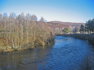
Loch Ness is a large freshwater loch in the Scottish Highlands extending for approximately 37 kilometres along the length of the Great Glen southwest of Inverness. It takes its name from the River Ness, which flows from the northern end. Loch Ness is best known for claimed sightings of the cryptozoological Loch Ness Monster, also known affectionately as "Nessie". It is one of a series of interconnected, murky bodies of water in Scotland; its water visibility is exceptionally low due to the high peat content of the surrounding soil. The southern end connects to Loch Oich by the River Oich and a section of the Caledonian Canal. The northern end connects to Loch Dochfour via the River Ness, which then ultimately leads to the North Sea via the Moray Firth.

The River Add is a river which runs through Argyll and Bute on the west coast of Scotland. Historically, it was known as the river Airigh but to avoid confusion with the Aray, it was renamed the River Add.

The River Garry in Inverness-shire is a Scottish river punctuated by two long Lochs, in the region of Lochaber. It flows broadly west to east through Glen Garry, starting in a wilderness to the east of Knoydart and ending at Loch Oich in the Great Glen, which forms part of the Caledonian Canal. There are a few tiny settlements within Glen Garry, but the only village of any size near to the river is Invergarry, at its mouth. Loch Quoich at the western end of the watercourse is dammed by the largest mass earth fill dam in Scotland, and supplies water to Quoich hydroelectric power station. Loch Garry is dammed by a much smaller dam in the gorge where the river begins its descent to Invergarry, and supplies water to Invergarry hydroelectric power station, close to the mouth of the river. Both hydroelectric schemes were built in the 1950s, with the aim of stimulating economic regeneration in the area. They have altered the ecology of the river, as both lochs were made considerably bigger as a result of constructing the dams.

The River Helmsdale is one of the major east-flowing rivers of Sutherland in the Highlands of Scotland. It flows broadly southeastwards from Loch Badanloch down the Strath of Kildonan, gathering the waters of the Bannock Burn on its left and the Abhainn na Frithe on its right before discharging into the Moray Firth on the North Sea at the town of Helmsdale. Other significant tributaries of the Helmsdale include the left-bank Suisgill Burn and the right-bank Craggie Water. Loch Achnamoine which is just over 1 km in length, lies on the line of the river 1 mi / 1.5 km downstream of Loch Badanloch. Loch Badanloch is one of a complex of three interconnecting lochs - the other two being Loch nan Clàr and Loch Rimsdale which gather waters from the moors on the southern edge of the Flow Country via the Allt an Lòin Tharsuinn, Allt Lòn a' Chùil and Rimsdale Burn.

The River Garry is a major tributary of the River Tummel, itself a tributary of the River Tay, in the traditional county of Perthshire in the Scottish Highlands. It emerges from the northeastern end of Loch Garry (56.8193°N 4.2311°W), just to the southeast of the Pass of Drumochter, and flows southeastwards and eastwards down Glen Garry to the narrow Pass of Killiecrankie beyond which it joins the Tummel (56.7182°N 3.7790°W).
The River Moriston is a river in Inverness-shire, Scotland. It flows broadly east-north-east from the outfall of the dam at Loch Cluanie to Loch Ness. Its waters and those of its tributaries have been harnessed to generate hydro-electric power.
Allt a' Chaol Ghlinne—also spelled Allt a' Chaol-ghlinne—is a river in the Lochaber area of Highland, Scotland. Located in a glen (valley) within the Northwest Highlands of the Scottish Highlands, Allt a' Chaol Ghlinne is a tributary to the River Finnan, which itself flows into Loch Shiel.