Kinness Burn

Last updated
Kinness Burn
Kinness Burn and inner harbour. - geograph.org.uk - 152676.jpg
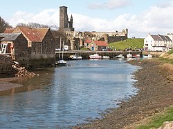
Kinness Burn and the inner harbour of St Andrews. St Rule’s Tower and the ruins of the Cathedral are in the background.
Location
Country Scotland
Physical characteristics
Mouth North Sea
  location
St Andrews
  coordinates
56°20′22″N2°47′01″W / 56.3395°N 2.7835°W / 56.3395; -2.7835 Coordinates: 56°20′22″N2°47′01″W / 56.3395°N 2.7835°W / 56.3395; -2.7835

The Kinness Burn is a 5+34 miles (9.5 kilometres) long burn (stream) in Fife, Scotland. It flows into the North Sea through the inner harbour of St Andrews on the east coast of Fife. The name of the village of Strathkinness, located 3 miles west of St Andrews, means the valley (strath) of the Kinness. [1] The source of the burn is on a low Clatto hill to the west of Strathkinness, [2] near the village of Blebocraigs. [3]

The St Andrews Botanic Garden is located on the banks of the Kinness Burn.

The Fife Pilgrim Way follows the Kinness Burn for about a mile within St Andrews, where it joins the Lade Braes Walk. [4]

Related Research Articles

<span class="mw-page-title-main">Kinglassie</span> Human settlement in Scotland

Kinglassie is a small village and parish in central Fife, Scotland. It is located two miles southwest of Glenrothes. It has a population of around 1,900 (mid-2020 est.) The civil parish has a population of 22,543.

<span class="mw-page-title-main">Fife</span> Council area of Scotland

Fife is a council area, historic county, registration county and lieutenancy area of Scotland. It is situated between the Firth of Tay and the Firth of Forth, with inland boundaries with Perth and Kinross and Clackmannanshire. By custom it is widely held to have been one of the major Pictish kingdoms, known as Fib, and is still commonly known as the Kingdom of Fife within Scotland. A person from Fife is known as a Fifer. In older documents the county was very occasionally known by the anglicisation Fifeshire.

<span class="mw-page-title-main">St Andrews</span> Town in Fife, Scotland

St Andrews is a town on the east coast of Fife in Scotland, 10 miles southeast of Dundee and 30 miles northeast of Edinburgh. St Andrews had a recorded population of 16,800 as of 2011, making it Fife's fourth-largest settlement and 45th most populous settlement in Scotland.

<span class="mw-page-title-main">Inverkeithing</span> Town in Scotland

Inverkeithing is a port town and parish, in Fife, Scotland, on the Firth of Forth. A town of ancient origin, Inverkeithing was given royal burgh status during the reign of Malcolm IV in the 12th century. It was an important center of trade during the Middle Ages, and its industrial heritage built on quarrying and ship breaking goes back to the 19th century. In 2016, the town had an estimated population of 4,890, while the civil parish was reported to have a population of 8,090 in 2011.

<span class="mw-page-title-main">Ceres, Fife</span> Human settlement in Scotland

Ceres is a village in Fife, Scotland, located in a small glen approximately 2 miles (3 km) over the Ceres Moor from Cupar and 7 mi (11 km) from St Andrews. The former parish of that name included the settlements of Baldinnie, Chance Inn, Craigrothie, Pitscottie and Tarvit Mill.

<span class="mw-page-title-main">Anstruther</span> Town in Fife, Scotland

Anstruther is a small coastal resort town in Fife, Scotland, situated on the north-shore of the Firth of Forth and 9 mi (14 km) south-southeast of St Andrews. The town comprises two settlements, Anstruther Easter and Anstruther Wester, which are divided by a stream, the Dreel Burn. With a population of 3,500, it is the largest community on the Firth of Forth's north-shore coastline known as the East Neuk. To the east, it merges with the village of Cellardyke.

Kingsbarns is a village and parish in Scotland lies near the eastern coast of Fife, in an area known as the East Neuk, 6.5 miles (10.5 km) southeast of St Andrews and 3.6 miles (5.8 km) north of Crail. The name derives from the area being the location of the barns used to store grain before being transported to the Palace at Falkland.

<span class="mw-page-title-main">Elie and Earlsferry</span> Human settlement in Scotland

Elie and Earlsferry is a coastal town and former royal burgh in Fife, and parish, Scotland, situated within the East Neuk beside Chapel Ness on the north coast of the Firth of Forth, eight miles east of Leven. The burgh comprised the linked villages of Elie to the east and to the west Earlsferry, which were formally merged in 1930 by the Local Government (Scotland) Act 1929. To the north is the village of Kilconquhar and Kilconquhar Loch.

Blebo Craigs, or Blebocraigs is a village in rural Fife, Scotland. The village contains around one hundred houses on the south-facing slope of the hill. Blebo Craigs is 5 miles from St Andrews.

<span class="mw-page-title-main">Markinch</span> Human settlement in Scotland

Markinch (, is both a village and a parish in the heart of Fife, Scotland. According to an estimate taken in 2008, the village has a population of 2,420. The civil parish had a population of 16,530. Markinch is east of Fife's administrative centre, Glenrothes and preceded Cupar as Fife's place of warranty and justice prior to the 13th century.

St Andrews Cathedral Priory was a priory of Augustinian canons in St Andrews, Fife, Scotland. It was one of the great religious houses in Scotland, and instrumental in the founding of the University of St Andrews.

<span class="mw-page-title-main">Guardbridge</span> Human settlement in Scotland

Guardbridge is a village in the north-east of Fife, on the east coast of Scotland. It is approximately 3 miles (5 km) north-west of St Andrews, and is situated on the estuary of the River Eden, at the junction of the A91 road between St Andrews and Stirling and the A919/A914 road between Leuchars and the Tay Road Bridge.

Strathkinness is a small village located 3 miles to the west of St Andrews in North East Fife.

<span class="mw-page-title-main">Leslie, Fife</span> Human settlement in Scotland

Leslie is a large village and parish on the northern tip of the River Leven Valley, to the west of Glenrothes in Fife. According to the population estimates (2006), the village has a population of 3,092. The village was granted burgh of barony status by James II in 1458 for George Leslie who became the first Earl of Rothes. Later, this was upgraded to a police burgh in 1865.

<span class="mw-page-title-main">Gauldry</span> Human settlement in Scotland

Gauldry, locally sometimes The Gauldry, is a village in Fife, Scotland. It is located 3 kilometres (1.9 mi) southwest of Newport on Tay, 2 kilometres (1.2 mi) south-east of Balmerino, and 1 kilometre (0.62 mi) south of Bottomcraig.

<span class="mw-page-title-main">Way of St Andrews</span>

The Way of St Andrews is a Christian pilgrimage to St Andrews Cathedral in Fife, on the east coast of Scotland, UK, where the relics of the apostle, Saint Andrew, were once kept. A group started a revival in 2012 introducing new routes.

<span class="mw-page-title-main">Largo, Fife</span> Human settlement in Scotland

Largo is a parish in Fife, Scotland containing the villages of Upper Largo or Kirkton of Largo, Lower Largo and Lundin Links. It is bounded on the west by the parish of Scoonie, on the north by Ceres and on the east by the parishes of Newburn and Kilconquhar. It has a coastline of 2¾ miles along Largo bay. Inland it extends 3-4 ½ miles north from the south coast of Fife. Area 7,378 acres.

<span class="mw-page-title-main">Cameron, Fife</span> Human settlement in Scotland

Cameron is a parish in east Fife, Scotland, 3½ miles south-west of St Andrews.

The Riggin o Fife is an upland area of Fife, Scotland which runs eastward from the Markinch Gap and the Howe of Fife to form the elevated hinterland to the coastal villages of the East Neuk. At 290 m, Largo Law is the highest hill, with other high points including Clatto Hill, Drumcarrow Craig, Kellie Law and Tarvit Hill. The area is rural, populated by farms and hamlets, with a few small villages, such as Largoward and Peat Inn. Riggin denotes a high ridge, the roof, the backbone, the exposed parts or the watershed.

<span class="mw-page-title-main">Swilken Burn</span> Stream in St Andrews, Scotland

The Swilken Burn, or Swilcan Burn, is a 2+34 miles long burn (stream) in Fife, Scotland. It flows into the North Sea to the north of the town of St Andrews on the east coast of Fife.

References

  1. "Fife Place-name Data".
  2. "Scottish Places-Kinness Burn".
  3. "Scottish Places-Clatto Hill".
  4. "Fife Pilgrim Way in two halves: Glenrothes to St Andrews".