
The Islands of the Firth of Clyde are the fifth largest of the major Scottish island groups after the Inner and Outer Hebrides, Orkney and Shetland. They are situated in the Firth of Clyde between Ayrshire and Argyll and Bute. There are about forty islands and skerries. Only four are inhabited, and only nine are larger than 40 hectares. The largest and most populous are Arran and Bute. They are served by dedicated ferry routes, as are Great Cumbrae and Holy Island. Unlike the isles in the four larger Scottish archipelagos, none of the isles in this group are connected to one another or to the mainland by bridges.
The Outer Hebrides or Western Isles, sometimes known as the Long Isle/Long Island, is an island chain off the west coast of mainland Scotland. The islands are geographically coextensive with Comhairle nan Eilean Siar, one of the 32 unitary council areas of Scotland. They form part of the archipelago of the Hebrides, separated from the Scottish mainland and from the Inner Hebrides by the waters of the Minch, the Little Minch, and the Sea of the Hebrides. Scottish Gaelic is the predominant spoken language, although in a few areas English speakers form a majority.

Perthshire, officially the County of Perth, is a historic county and registration county in central Scotland. Geographically it extends from Strathmore in the east, to the Pass of Drumochter in the north, Rannoch Moor and Ben Lui in the west, and Aberfoyle in the south; it borders the counties of Inverness-shire and Aberdeenshire to the north, Angus to the east, Fife, Kinross-shire, Clackmannanshire, Stirlingshire and Dunbartonshire to the south and Argyllshire to the west. It was a local government county from 1890 to 1930.

The River Dee is a river in Aberdeenshire, Scotland. It rises in the Cairngorms and flows through southern Aberdeenshire to reach the North Sea at Aberdeen. The area it passes through is known as Deeside, or Royal Deeside in the region between Braemar and Banchory because Queen Victoria came for a visit there in 1848 and greatly enjoyed herself. She and her husband, Prince Albert, built Balmoral Castle there which replaced an older castle.

The County of Kinross or Kinross-shire is a historic county and registration county in eastern Scotland, administered as part of Perth and Kinross since 1930. Surrounding its largest settlement and county town of Kinross, the county borders Perthshire to the north and Fife to the east, south and west.
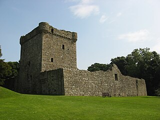
Lochleven Castle is a ruined castle on an island in Loch Leven, in the Perth and Kinross local authority area of Scotland. Possibly built around 1300, the castle was the site of military action during the Wars of Scottish Independence (1296–1357). In the latter part of the 14th century, the castle was granted to William Douglas, 1st Earl of Douglas, by his uncle. It remained in the Douglases' hands for the next 300 years. Mary, Queen of Scots, was imprisoned there in 1567–68, and forced to abdicate as queen, before escaping with the help of her gaoler's family. In 1588, the queen's gaoler inherited the title of Earl of Morton, and moved away from the castle. In 1675, Sir William Bruce, an architect, bought the castle and used it as a focal point for his garden; it was never again used as a residence.

Loch Rannoch is a freshwater loch in Perth and Kinross, Scotland. It is over 15 kilometres (9.3 mi) long in a west–east direction with an average width of about 1.2 kilometres (0.75 mi), and is deepest at its eastern end, reaching a depth of 130 metres (440 ft). The River Tummel begins at its eastern end, where the small village of Kinloch Rannoch can be found, whilst the wild expanse of Rannoch Moor extends to the west of the loch. The area surrounding Loch Rannoch, along with Rannoch Moor itself, was formerly part of the native Caledonian Forest that stretched across much of Northern Scotland. Native forest is now largely absent from much of the area, due partly to logging, and partly to the climate becoming wetter, and Loch Rannoch is now largely surrounded by commercial forestry and open hillsides, although a small area remains at the Black Wood of Rannoch on the southern shore of the loch.
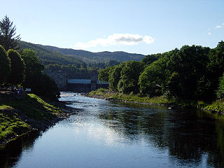
The River Tummel is a river in Perth and Kinross, Scotland. Water from the Tummel is used in the Tummel hydro-electric power scheme, operated by SSE.

Balmaghie, from the Scottish Gaelic Baile Mhic Aoidh, is an ecclesiastical and civil parish in the historical county of Kirkcudbrightshire in Dumfries and Galloway, Scotland and was the seat of the McGhee family. It is bordered by the River Dee to the north and east. Threave Castle stands on an island in the river. The River Dee is commonly known as the Black Water of Dee on the northern border, the name changes with the meeting of the Water of Ken to the north west and is then known as Loch Ken along the eastern border. Balmaghie parish borders Girthon to the west and Tongland and Twynholm to the south. The closest market town is Castle Douglas about 6 miles from Balmaghie Kirk.

Loch Tummel is a long, narrow loch, seven kilometres northwest of Pitlochry in the council area of Perth and Kinross, Scotland. It is fed and drained by the River Tummel, which flows into the River Tay about 13 km (8 mi) south-east of the Clunie Dam at the loch's eastern end.

Bridge of Earn is a small town in Perthshire, Scotland. Often referred to simply as 'The Brig'. The village grew up on the south bank of an important crossing of the River Earn, whose sandstone bridge existed from at least the early 14th century, when it is known to have been repaired by order of King Robert I of Scotland (1306–1329). Substantial remains of the medieval bridge survived into the 1970s, when almost all the stonework was demolished, for (allegedly) being in a dangerously ruinous condition. This ancient bridge was a major landmark on the road between Edinburgh and Perth for several centuries. The village's oldest houses are to be found lining the road leading south from the site of the demolished bridge. Among them are some with 18th-century datestones.

Banton is a small village situated near Kilsyth in North Lanarkshire, Scotland.

Clunie is a small settlement in Perthshire, Scotland, four miles west of Blairgowrie. It lies on the western shore of the Loch of Clunie.

Forgandenny is a small village in Perth and Kinross, Scotland, located four miles south of Perth. Perth is a 20-minute bus ride from Forgandenny, and there is a regular Stagecoach service. It is 45 minutes from Edinburgh and one hour from Glasgow. There is a daily train service from Perth to London King's Cross.

Tingwall, is a parish in Shetland, Scotland. Located mostly on the Shetland Mainland, the centre lies about 2 miles north of Scalloway. Tingwall Airport is located in the village.
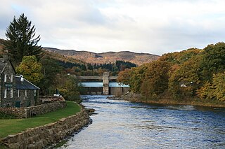
The Tummel hydro-electric power scheme is an interconnected network of dams, power stations, aqueducts and electric power transmission in the Grampian Mountains of Scotland. Roughly bounded by Dalwhinnie in the north, Rannoch Moor in the west and Pitlochry in the east it comprises a water catchment area of around 1,800 square kilometres (690 sq mi) and primary water storage at Loch Ericht, Loch Errochty, Loch Rannoch and Loch Tummel, in Perth and Kinross. Water, depending on where it originates and the path it takes, may pass through as many as five of the schemes nine power stations as it progresses from north-west to south-east. The scheme was constructed in the 1940s and 50s incorporating some earlier sites. It is currently managed by SSE plc.
Fraoch Eilean/Ejlean is a small island situated at the northern end of Loch Awe, a freshwater lake in Argyll and Bute, Scotland. It is notable for being the site of a medieval royal castle, now ruined, which was given into the keeping of Clan Macnaghten by Alexander III in 1267.


