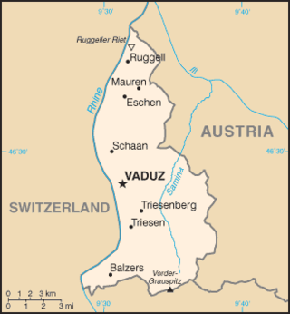
The principality of Liechtenstein encompasses most of the eastern half of the Rhine Valley, wedged between Austria and Switzerland. The majority of the country's population is found in the western half along the Rhine River. Along with Uzbekistan, Liechtenstein is one of only two doubly landlocked countries in the world.

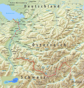
The Rhine is one of the major European rivers. The river begins in the Swiss canton of Graubünden in the southeastern Swiss Alps. It forms part of the Swiss-Liechtenstein border, then part of the Swiss-Austrian border. From Lake Constance downstream, it forms part of the Swiss-German border. After that the Rhine defines much of the Franco-German border. It then flows in a mostly northerly direction through the German Rhineland. Finally in Germany, the Rhine turns into a predominantly westerly direction and flows into the Netherlands where it eventually empties into the North Sea. It drains an area of 9,973 km2.

Austria is a predominantly mountainous country in Central Europe, approximately between Germany, Italy and Hungary. It has a total area of 83,871 square kilometres (32,383 sq mi).

Lake Constance refers to three bodies of water on the Rhine at the northern foot of the Alps: Upper Lake Constance (Obersee), Lower Lake Constance (Untersee), and a connecting stretch of the Rhine, called the Seerhein. These waterbodies lie within the Lake Constance Basin in the Alpine Foreland through which the Rhine flows. The nearby Mindelsee is not considered part of Lake Constance. The lake is situated where Germany, Switzerland, and Austria meet. Its shorelines lie in the German states of Baden-Württemberg and Bavaria; the Swiss cantons of St. Gallen, Thurgau, and Schaffhausen; and the Austrian state of Vorarlberg. The actual locations of the country borders within the lake are disputed.

The Upper Rhine is the section of the Rhine between the Middle Bridge in Basel, Switzerland, and the Rhine knee in Bingen, Germany. It is surrounded by the Upper Rhine Plain. Most of its upper section marks the France–Germany border.
The Rhein-Erft-Kreis is a district in the west of North Rhine-Westphalia, Germany. Neighboring districts are Neuss, district-free Cologne, Rhein-Sieg, Euskirchen, Düren.

The Inn is a river in Switzerland, Austria and Germany. The 518 km (322 mi) long river is a right tributary of the Danube, being the third largest tributary of the Danube by discharge. The highest point of its drainage basin is the summit of Piz Bernina at 4,049 m (13,284 ft). The Engadine, the valley of the En, is the only Swiss valley whose waters end up in the Black Sea.

A landlocked country is a country that does not have any territory connected to an ocean or whose coastlines lie solely on endorheic basins. Currently, there are 44 landlocked countries, two of them doubly landlocked, and three landlocked de facto states in the world. Kazakhstan is the world's largest landlocked country, Kyrgyzstan is the furthest landlocked country from any ocean, while Ethiopia is the world's most populous landlocked country.

The Alpine Rhine Valley is a glacial alpine valley, formed by the Alpine Rhine, the part of the Rhine between the confluence of the Anterior Rhine and Posterior Rhine at Reichenau and Lake Constance. It covers three countries, with sections of the river demarcating the borders between Austria and Switzerland and between Liechtenstein and Switzerland. The full length of the Alpine Rhine is 93.5 km.

An endorheic basin is a drainage basin that normally retains water and allows no outflow to other external bodies of water ; instead, the water drainage flows into permanent and seasonal lakes and swamps that equilibrate through evaporation. Endorheic basins are also called closed basins, terminal basins, and internal drainage systems.

The Eastern Alps are usually defined as the area east of a line from Lake Constance and the Alpine Rhine valley, up to the Splügen Pass at the Alpine divide, and down the Liro River to Lake Como in the south. The peaks and mountain passes are lower than the Western Alps, while the range itself is broader and less arched.

High Rhine is the name of the part of the Rhine between Lake Constance and the city of Basel, flowing in a general east-to-west direction and forming mostly the Germany–Switzerland border. It is the first of four named sections of the Rhine between Lake Constance and the river delta at the North Sea.
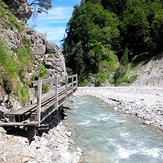
The Samina is a whitewater river of Liechtenstein and Austria. It is a tributary of the Ill.

The hydrology of Hungary, is mostly determined by Hungary's lying in the middle of the Carpathian Basin, half surrounded by the Carpathian Mountains. All parts of the country have some outflow. All surface water gravitates towards its southern center, and from there, is united in the Danube, which flows into the Black Sea. The whole of Hungary lies within the Danube drainage basin.

The Alter Rhein is the old river bed of the Alpine Rhine in St. Gallen and Vorarlberg in the Alpine Rhine Valley, which was cut off when the Rhine was straightened during the 20th century. These cut-off arms have become valuable recreational areas and a nature reserve.
The border between the modern states of Austria and Switzerland is divided into two parts, separated by the Principality of Liechtenstein, with a total length of 180 km (110 mi). The longer, southern stretch runs across the Grison Alps and the shorter one following mostly the Alpine Rhine, except near Diepoldsau and between Lustenau and Lake Constance, where it follows the Old Rhine bed. The border continues northward to the Austrian-Swiss-German tripoint located within Upper Lake Constance.

The Regulation of the Rhine or Rhine Correction, refers to the canalisation of the Alpine Rhine on the border between Austria and Switzerland in the late 19th/early 20th century. Its aim was to reduce the risk of flooding and to re-route the international border which ran along the old course of the Rhine.
The geology of Liechtenstein formed at the intersection of the Eastern and Western Alps and the country occupies a wider than average river valley on the Rhine River, running north–south. A spur of the Rätikon Mountains flanks the river to the east, while Schellenberg hill is a defining topographic high in the north.

The Rhine delta of Lake Constance is the river delta on the southeastern shore of Lake Constance, which the Rhine has formed in a former sea area. It lies mostly in the Austrian province of Vorarlberg, smaller areas are in the Swiss canton of St. Gallen. The two peninsulas in the lake are called Rheinspitz (west) and Rohrspitz (east).

