List of rivers of Iceland

Last updated

The Alfar Vatnsdalur 03.jpg
The Álfar

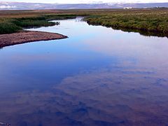
On an island like Iceland, the rivers are short in length. None of the rivers are important as a means of navigation due to the impracticality of settlements in the Highlands of Iceland where they originate.

Contents

South


West

Westfjords

North

East

The mouth of the Hamarsa, Hamarsfjordur Hamarsa Mouth.jpg
The mouth of the Hamarsá, Hamarsfjörður

See also

Related Research Articles

Einar Benediktsson, often referred to as Einar Ben, was an Icelandic poet and lawyer.

Dettifoss

Dettifoss is a waterfall in Vatnajökull National Park in Northeast Iceland, and is reputed to be the second most powerful waterfall in Europe after the Rhine Falls. Dettifoss is situated on the Jökulsá á Fjöllum river, which flows from the Vatnajökull glacier and collects water from a large area in Northeast Iceland. The sediment-rich runoff colours the water a greyish white.

Jökulsá á Fjöllum River in Iceland

Jökulsá á Fjöllum is the second longest river in Iceland (206 km). Its source is the Vatnajökull glacier. It flows into the Greenland Sea. Jökulsá á Fjöllum streams over the waterfalls Selfoss, Dettifoss, Hafragilsfoss, and Réttarfoss, the second of which is the most powerful waterfall in Europe.

Hvítá (Árnessýsla) River in Iceland

Hvítá is a river in Iceland that begins at Hvítárvatn glacier lake on Langjökull glacier in the highlands of Iceland at 64°37′N19°50′W. The river flows for 40 kilometres (25 mi) before dropping down into a narrow gorge at Gullfoss waterfall.

Kárahnjúkar Hydropower Plant Dam

Kárahnjúkar Hydropower Plant, officially called Fljótsdalur Power Station is a hydroelectric power plant in Fljótsdalshérað municipality in eastern Iceland, designed to produce 4,600 gigawatt-hours (17,000 TJ) annually for Alcoa's Fjarðaál aluminum smelter 75 kilometres (47 mi) to the east in Reyðarfjörður. With the installed capacity of 690 megawatts (930,000 hp), the plant is the largest power plant in Iceland. The project, named after the nearby Kárahnjúkar mountains, involves damming the rivers Jökulsá á Dal and Jökulsá í Fljótsdal with five dams, creating three reservoirs. Water from the reservoirs is diverted through 73 kilometres (45 mi) of underground water tunnels and down a 420-metre (1,380 ft) vertical penstock towards a single underground power station. The smelter became fully operational in 2008 and the hydropower project was completed in 2009.

Öxarfjörður

Öxarfjörður is a broad fjord in northeastern Iceland, situated between the Tjörnes and Melrakkaslétta headlands.

Lónsöræfi

Lónsöræfi is a wilderness area in south-east Iceland. The region is characterised by its varied geological formations. These mostly date from a period between 5 to 7 million years ago, when the volcano Kollumúlaeldstöðvar [ˈkʰɔtlʏˌmuːlaˌɛltˌstœðvar̥] was active. The glacier tongues of the eastern extreme of Vatnajökull also impose themselves on the area. Visible to the north-west is Snæfell [ˈstnaiːˌfɛtl̥] (1833m), the highest peak in Iceland that isn't part of a glacier. The mountains within the area itself include Sauðhamarstindur [ˈsœiðˌhaːmar̥sˌtʰɪntʏr̥] (1319m) and Jökulgilstindar [ˈjœːkʏlˌkɪlsˌtʰɪntar̥].

Jökulsá is the name of several rivers in Iceland.

Selfoss (waterfall)

Selfoss is a waterfall on the river Jökulsá á Fjöllum in the north of Iceland. The river drops over a number of waterfalls over about 30 km before flowing into Öxarfjörður, a bay of the Arctic Sea. The river originates as melt water from the glacier Vatnajökull and therefore the water flow varies depending on the season, the weather and volcanic activity.

Rangárþing eystra Municipality in Southern Region, Iceland

Rangárþing eystra is a municipality located in southern Iceland in the Southern Region, between Eystri Rangá in the west and Jökulsá á Sólheimasandi in the east. The largest settlements are Skógar and Hvolsvöllur.

Farthings of Iceland

Historically, Iceland was divided into four farthings corresponding to the cardinal directions. These were administrative divisions established in 965 for the purpose of organising regional assemblies called farthing assemblies (fjórðungsþing) and regional courts called farthing courts (fjórðungsdómar). Each farthing held three local assemblies, which were each presided over by three goðar or chieftains. The North Farthing alone held four. Farthing courts would judge cases if both plaintiff and defendant belonged to the same assembly; otherwise the case was brought to the general assembly, the Alþingi. Little else is known about these farthing courts and they seem to have been much more irregular than the spring and autumn assemblies. Also, in spite of the apparent regularity of three goðar per assembly and three to four assemblies per farthing, the system of rule by chieftains and assemblies probably followed a much more varied pattern.

Héraðsflói

Héraðsflói is a bay in eastern Iceland, formed by the outflowing of the Jökulsá á Brú and Lagarfljót rivers. The ~25 km-long beach is the Héraðssandur.

Öræfasveit

Öræfasveit or Öræfi[ˈœːrˌaiːvɪ] is a western region in Austur-Skaftafellssýsla, Iceland. It lies between Breiðamerkursandur and the river Skeiðará, east of the village of Kirkjubæjarklaustur and South, West and East of the Öræfajökull volcano. It has been a part of the municipality of Hornafjörður since 1998. In the Middle Ages, this region was called Hérað or Litlahérað, but was deserted in the wake of the 1362 eruption of Öræfajökull and the subsequent flooding of the region. After these events the region was simply called Öræfi ("wilderness/desolation").

Hafragilsfoss

Hafragilsfoss is a waterfall in Iceland.

Hálslón Reservoir

The Hálslón Reservoir is a storage reservoir in Eastern Iceland on the Jökulsá á Dal River. The reservoir stores water for use in hydroelectricity production with the Kárahnjúkar Hydropower Plant. The reservoir was formed by three different concrete-faced, rock-filled embankment dams: the Kárahnjúkastífla Dam, the Desjarárstífla Dam [ˈtɛːsjarˌaurˌstipla] and the Sauðárdalsstífla Dam [ˈsœiːðˌaurˌtalsˌstipla].

Jökulsá á Dal River in Iceland

Jökulsá á Dal, also called Jökulsá á Brú[ˈpruː] or Jökla, [ˈjœʰkla] is a river in the northeast of Iceland.

Dyngjujökull

Dyngjujökull is an outlet glacier of the Vatnajökull glacier in Vatnajökull National Park, Iceland. The glacier is in the Icelandic Highlands and is situated between Bárðarbunga, Holuhraun and Kverkfjöll. Meltwater from the glacier flows into Jökulsá á Fjöllum, the second longest river in Iceland.

Jökulsá á Breiðamerkursandi River in Iceland

Jökulsá á Breiðamerkursandi is a river in Southeast Iceland in Austur-Skaftafellssýsla in the middle of Breiðamerkursandur, a glacial outwash plain.

Rauðhólar (Vesturdalur)

Rauðhólar (Vesturdalur) is a small chain of volcanoes within the Askja or the Fremrinámur volcanic systems in the north of Iceland.