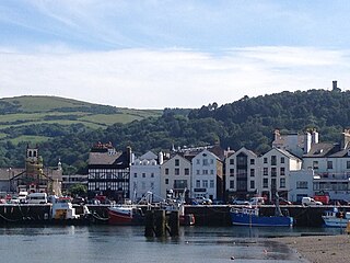
Ramsey is a coastal town in the north of the Isle of Man. It is the second largest town on the island after Douglas. Its population is 7,845 according to the 2016 Census. It has one of the biggest harbours on the island, and has a prominent derelict pier, called the Queen's Pier. It was formerly one of the main points of communication with Scotland. Ramsey has also been a route for several invasions by the Vikings and Scots.
Sulby is a place name that may refer to:

Cudlee Creek is a small town near Adelaide, South Australia. It is located in the Adelaide Hills Council local government area.

River Sulby can refer to one of two rivers on the Isle of Man:

Ayre is one of the six sheadings of the Isle of Man.

Lezayre, formally Kirk Christ Lezayre, is one of the seventeen historic parishes of the Isle of Man.

Sulby Glen is a partly wooded glen in the parish of Lezayre in the Isle of Man. It runs north to south and is about 5 km long. In places the floor of the glen is only 50 metres wide, with steep sides.

The Isle of Man TT Mountain Course or TT Course is a street and public rural road circuit located in the Isle of Man, used for motorcycle racing. The motorcycle TT Course is used principally for the Isle of Man TT Races and also the separate event of the Isle of Man Festival of Motorcycling for the Manx Grand Prix and Classic TT Races held in September of each year. The start-line for the Isle of Man TT Mountain Course is located on Glencrutchery Road in the town of Douglas, Isle of Man.

The Sulby Reservoir is the largest reservoir or lake in the Isle of Man, with an area of 154 acres (62 ha).

Sulby is a village in the parish of Kirk Christ Lezayre that is located on the A3 Castletown to Ramsey in the Isle of Man.

Sulby Glen Railway Station was a station on the Manx Northern Railway, later owned and operated by the Isle of Man Railway; it served the village of Sulby in the Isle of Man and was an intermediate stopping place on a line that ran between St. John's and Ramsey.

Sulby BridgeRailway Station was a station on the Manx Northern Railway (MNR), later owned and operated by the Isle of Man Railway; it served the village of Sulby in the Isle of Man and was an intermediate stopping place on a line that ran between St. John's and Ramsey.

Ginger Hall is an uphill left-hand bend following Sulby Bridge on the Isle of Man TT course, a traditionally popular spectator and photographer vantage point with views of motorcycles approaching from Sulby Bridge and exiting towards Kerrowmoar. Situated on a corner-junction, the adjacent Ginger Hall Hotel dates from the mid-19th century and offers refreshments and access to another major viewing area at the Bungalow close to the summit of Snaefell mountain via the B8 Claddagh Road and the A14 Sulby Road.

The Silver Burn or Silverburn River is a small river, about five miles (8 km) long, on the Isle of Man which rises near the South Barrule and flows south. It passes St Mark's and in its lower reaches it flows under the Monks' Bridge at Ballasalla, and reaches the sea at Castletown harbour. Just above Ballasalla, the burn runs through wooded Silverdale Glen, a site which the Manx National Trust acquired in 1966.

Ballaugh Bridge is located on the primary A3 Castletown to Ramsey road and adjacent to the road junctions with the A10 Ballaugh to Ramsey coast road and the tertiary C37 Ballaugh Glen Road in the parish of Ballaugh in the Isle of Man.

Manx National Glens is a collective term for a series of glens in the Isle of Man which have been officially designated as tourist attractions. They are maintained by the Department of Environment, Food and Agriculture. The island is known for its "pocket sized" natural glens.
This is a list of Registered Buildings and Conservation Areas of the Isle of Man. It includes buildings and structures in the Isle of Man designated by Isle of Man's Department of Environment, Food and Agriculture (DEFA) "as having special architectural or historical interest". Over 250 buildings and structures are listed, and 275 more have been identified as having potential for listing. It also lists the 21 Conservation Areas, historic districts" which protect "period"-type architecture, quality of building materials, relationships of enclosures and open spaces, and other aspects of the look and feel of historic buildings and areas.

West Baldwin Reservoir is a reservoir on the Isle of Man, about 6 miles (9.7 km) north of Douglas which it supplies. It was constructed by building a dam across a valley, and flooding the valley. Remains of a village in the valley can still be seen when the reservoir level is low. It is operated by the Isle of Man Water Authority.

Glen Auldyn is a narrow valley about 6 kilometres (3.7 mi) long on the Isle of Man, with a river of the same name. This flows in a NNE direction and flows into the River Sulby not far from its estuary, near Ramsey. It is entirely within the parish of Lezayre. The lower one-third of the valley is inhabited and is partly followed by the B16 road. This section is overlooked by Sky Hill.