The Isle of Man has a coastline of 160km (99mi), and a territorial sea extending to a maximum of 12 nm from the coast, or the midpoint between it and other countries. The total territorial sea area is about 4000km2 or 1500 sq miles, which is about 87% of the total area of the jurisdiction of the Isle of Man. The Isle of Man only holds exclusive fishing rights in the first 3 nm. The territorial sea is managed by the Isle of Man GovernmentDepartment of Infrastructure.
The Raad ny Foillan long-distance footpath runs 153km (95mi) around the Manx coast.
Climate
The Isle of Man enjoys a temperate climate, with cool summers and mild winters. Average rainfall is high compared to the majority of the British Isles, due to its location to the western side of Great Britain and sufficient distance from Ireland for moisture to be accumulated by the prevailing south-westerly winds. Average rainfall is highest at Snaefell, where it is around 1,900mm (74.8in) a year. At lower levels, it can fall to around 800mm (31.5in) a year.
Temperatures remain fairly cool, with the recorded maximum being 28.9°C (84.0°F) at Ronaldsway.
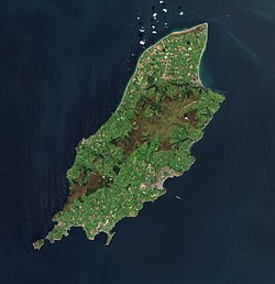
Some of the island's mountainous terrain as viewed from Snaefell, the island's highest peak.Enlargeable, detailed map of the Isle of Man
The island's terrain is varied. There are two mountainous areas divided by a central valley which runs between Douglas and Peel. The highest point in the Isle of Man, Snaefell, is in the northern area and reaches 620 metres (2,034ft)above sea level. The northern end of the island is a flat plain, consisting of glacial tills and marine sediments. To the south, the island is more hilly, with distinct valleys. There is no land below sea level.
Land use
Arable land: 43.86%
Permanent crops: 0%
Other: 56.14% (includes permanent pastures, forests, mountain and heathland) (2011)
Natural hazards and environmental issues
There are few severe natural hazards, the most common being high winds, rough seas and dense fog. In recent years there has been a marked increase in the frequency of high winds, heavy rains, summer droughts and flooding both from heavy rain and from high seas. Snow fall has decreased significantly over the past century while temperatures are increasing year-round with rainfall decreasing.
Protected or recognised sites for nature conservation
In order of importance, international first, non-statutory last. Note that ASSIs and MNRs have equal levels of statutory protection under the Wildlife Act 1990.
There are 25 ASSIs on the Isle of Man as of November 2022. One additional ASSI has been designated but later rescinded (Ramsey Estuary). Dates below refer to year of formal confirmation.
The Island's first marine nature reserve was designated in Ramsey Bay in October 2011.[15][16] In 2018, nine further Marine Nature Reserves were given statutory protection. The ten Marine Nature Reserves around the Isle of Man cover over 10% of the country's territorial waters, in accordance with international requirements.[17][18]
Eelgrass Conservation Zones (Statutory – within MNRs)
Eelgrass Zostera marina is a legally protected species on the Isle of Man.[19] Between 2011 and 2018, four strictly protected Eelgrass Conservation Zones have been designated to protect this important species.[20]
Ramsey Bay MNR - Port Lewaigue & Ballure area (2011)
Eelgrass Voluntary Zones (Non-statutory – both in and outside MNRs)
In 2023, three existing statutory Eelgrass Conservation Zones were expanded on a voluntary basis (noting that, regardless of this 'voluntary' status, the species is still legally fully protected from reckless disturbance), with a further new site identified.[20]
Ramsey Bay - a considerably larger area than the statutory zone (2023)
Langness - Derbyhaven Bay, northwest of Fort Island, separate from the Fort Island Gully statutory site (2023)
Laxey Bay - a considerably larger area than the statutory zone (2023)
Bulgham Bay - discovered in 2021, the only Eelgrass Voluntary Zone outside of an MNR (2023)
Bird sanctuaries were formerly designated by that name under the Wild Birds Protection Act 1932. This designation was superseded by "Areas of Special Protection for Birds" under the Wildlife Act 1990; however, the following formerly designated Bird Sanctuaries remain protected:
Manx Wildlife Trust (MWT) was founded on 6 March 1973 and is the Isle of Man’s leading nature conservation charity.
As of May 2025, MWT manages 32 nature reserves, including the Calf of Man which is managed with and on behalf of Manx National Trust. These reserves total 1,015.68ha (2,509.8 acres), or around 2% of the Isle of Man and include:
Name
Acquired
Area
Notes
Aust
2016
4.20ha (10.4 acres)
Ballachrink
2011
10.08ha (24.9 acres)
Part of the Renscault & Ballachrink Bird Sanctuary
Part of the Ballaugh Curraghs ASSI and Ramsar Site
Mullen e Cloie
2008
1.14ha (2.8 acres)
The Keyllagh
2024
10.44ha (25.8 acres)
Total
1,015.68ha (2,509.8 acres)
This represents approximately 2% of the Isle of Man's land area (57,198ha)
Designated Wildlife Sites
The Isle of Man has (as of March 2023) 92 non-statutory 'Wildlife Sites' covering 1,230.54 hectares (3,040.7 acres) in addition to the 10.4km of coastline. As of 30 January 2009 this total was 45 wildlife sites, covering about 195 ha of land and an additional 10.5km (6.5mi) of inter-tidal coast. Wildlife Sites are not recognised in law, but are recognised in terms of Government policy, including planning and zonation (by the Isle of Man Strategic Plan) and agricultural policy (under Cross Compliance regulations). Wildlife Sites are shown on the MANNGIS Island Environment map.
The following properties are under the protection of Manx National Heritage. The Manx National Trust owns properties in 15 of the 17 Manx parishes (all except Jurby and Michael).
The majority of the island is formed from highly faulted and folded sedimentary rocks of the Ordovician period. There is a belt of younger Silurian rocks along the west coast between Niarbyl and Peel, and a small area of Devonian sandstones around Peel. A band of Carboniferous period rocks underlies part of the northern plain, but is nowhere seen at the surface; however similar age rocks do outcrop in the south between Castletown, Silverdale and Port St Mary. Permo-Triassic age rocks are known to lie beneath the Point of Ayre but, as with the rest of the northern plain, these rocks are concealed by substantial thicknesses of superficial deposits.[28]
The island has significant deposits of copper, lead and silver, zinc, iron, and plumbago (a mix of graphite and clay).[29] There are also quarries of black marble, limestone flags, clay schist, and granite.[30] These are all modern, and there was no noticeable exploitation of metals or minerals before the modern era.
Demographics
Aerial view of Douglas and the southern half of the Isle of Man
The island has a census-estimated population of 84,497 according to the most recent 2011 census: up from 79,805 in 2006 and 76,315 in 2001.
The island's largest town and administrative centre is Douglas, whose population is 23,000 – over a quarter of the population of the island. Neighbouring Onchan, Ramsey in the north, Peel in the west and the three southern ports of Castletown, Port Erin and Port St Mary are the island's other main settlements. Almost all its population lives on or very near the coast.
This page is based on this Wikipedia article Text is available under the CC BY-SA 4.0 license; additional terms may apply. Images, videos and audio are available under their respective licenses.