
The Isle of Man is mostly hilly, but has only one summit, Snaefell, classified as a mountain (over 2,000 feet).
The Isle of Man is mostly hilly, but has only one summit, Snaefell, classified as a mountain (over 2,000 feet).
The south of the island has a small coastal plain around Castletown and Ballasalla but is otherwise hilly. In the south west these hills rise to more prominent peaks, notably South Barrule (483 m), and Cronk ny Arrey Laa (437 m) which drops almost vertically into the sea. [1]
A central valley separates the southern hills from the central range which contains the highest peaks. This central range contains 11 out of 12 of the Island's highest peaks. It has open moorland and rough terrain. It is very sparsely populated and has just one major road crossing it except along the coast. [1]
This then drops quite suddenly to a large flat northern glacial till plain which has only small rolling hills (max. 96 m) known as the Bride hills. [1]
The Isle of Man contains five Marilyns:
| Peak | Height (m) | Prom. (m) | Key col (m) | Grid ref. | Parent |
|---|---|---|---|---|---|
| Snaefell | 621 | 621 | Sea | SC397881 | None, highest peak in the Isle of Man |
| South Barrule | 483 | 436 | 47 | SC257759 | Snaefell |
| Bradda Hill | 230 | 193 | 37 | SC193711 | South Barrule |
| Slieau Freoaghane | 488 | 153 | 335 | SC340883 | Snaefell |
| Mull Hill | 169 | 151 | 18 | SC189676 | Bradda Hill |
The Isle of Man contains 11 peaks which stand at over 1,500 ft. [2] All of these, except for the South Barrule (in the south) are found in the central range which spans the region between the central valley and the flat fertile northern plain. Although none of these peaks are especially high, they appear quite prominent and impressive due to their proximity to the sea. Whilst many of these peaks are rugged, they are not steep enough to provide many opportunities for technical climbing (which can be found in abundance around the coast). There are opportunities for scrambling in some areas, including the northern slopes of the North Barrule, around the Sloc, and the southern slopes of Greeba Mountain. These can provide a training ground for the higher steeper mountains in places such as Snowdonia and the Highlands of Scotland; they are also far less crowded than some of Britain's more popular hill destinations. All of these peaks can be reached by a rough hill walk.
| Hill | Height | Grid ref. | Area | |
|---|---|---|---|---|
| (ft) | (m) | |||
| Snaefell | 2,037 | 621 | 397881 | Central |
| North Barrule | 1,854 | 565 | 443909 | North East |
| Clagh Ouyr | 1,808 | 551 | 415890 | North East |
| Beinn-y-Phott | 1,785 | 544 | 381861 | Central |
| Slieau Freoaghane | 1,601 | 488 | 341883 | Michael Hills |
| Colden | 1,598 | 487 | 343843 | Central |
| South Barrule | 1,585 | 483 | 258759 | South West |
| Slieau Ruy | 1,572 | 479 | 329824 | Central |
| Sartfell | 1,490 | 454 | 335872 | Michael Hills |
| Carraghyn | 1,640 | 500 | 370850 | Central |
| Slieau Lhean | 1,539 | 469 | 426877 | East |
Additional heights above 1500 feet include Mullagh Ouyr (gr 398861) and two unnamed points on the ridge between Clagh Ouyr and the North Barrule (gr 425900 & 432904).

The Isle of Man is an island in the Irish Sea, between Great Britain and Ireland in Northern Europe, with a population of almost 85,000. It is a British Crown dependency. It has a small islet, the Calf of Man, to its south. It is located at 54°15′N4°30′W.

A fell is a high and barren landscape feature, such as a mountain or moor-covered hill. The term is most often employed in Fennoscandia, Iceland, the Isle of Man, parts of northern England, and Scotland.

The Snaefell Mountain Railway is an electric mountain railway on the Isle of Man in Europe. It joins the village of Laxey with the summit of Snaefell, at 2,036 feet (621 m) above sea level the highest point on the island. It connects with the Manx Electric Railway (MER) in Laxey. The line is 5 miles (8 km) long, is built to 3 ft 6 in gauge and uses a Fell Incline Railway System centre rail for braking on the steep gradients. It is electrified using overhead wires at 550 volts direct current, with bow collectors.

Snaefell – is the highest mountain and the only summit higher than 2,000 feet (610 m) on the Isle of Man, at 2,037 feet (620.9 m) above sea level. The summit is crowned by a railway station, cafe and several communications masts.

The South Barrule is the highest hill in the south of the Isle of Man. It has the remains of a fort on its summit, which is traditionally the home of the Manx god of the sea Mannanan beg mac y Leir. The hill is largely surrounded by conifer plantations. On the south western slope of the hill the Cringle Reservoir was formed to supply water to the southern part of the island. South Barrule's ancient name was Warfield or Wardfell.
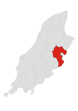
Lonan is one of the 17 parishes of the Isle of Man.
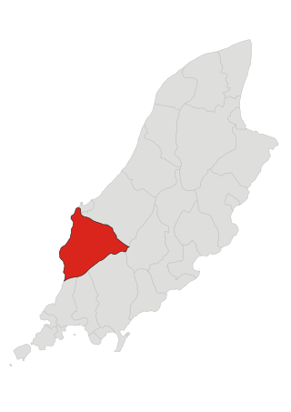
Patrick is one of the seventeen historic parishes of the Isle of Man.

Kaaterskill High Peak is one of the Catskill Mountains, located in the Town of Hunter in Greene County, New York, United States. It was once believed to be the highest peak in the entire range, but its summit, at 3,655 feet (1,114 m) in elevation, places it only 23rd among the Catskill High Peaks. It is, however, the fourth most prominent peak in the range. Due to its situation as the easternmost High Peak, its summit is just outside the watersheds of New York City's reservoirs in the region.

26th Milestone, Isle of Man is situated on the primary A18 Snaefell Mountain Road in the parish of Lezayre in the Isle of Man. At the 26th Milestone racing marker used for the Isle of Man TT Races and Manx Grand Prix, the bend was named in honour of 26-times TT winner Joey Dunlop who died after a racing motorcycle crash in Estonia in July 2000. The area is the location of the only accident in which spectators at the Isle of Man TT races or Manx Grand Prix have been killed in a motorcycle racing accident.

Keppel Gate, Isle of Man is part of a former UK HM Commissioners of Woods and Forest estate, including a series of former highway mountain gates. It is now Common land in public ownership and is one of three purpose built former Crown Road sections of the A18 Snaefell Mountain Road used for the Isle of Man TT races. The area of Keppel Gate including a nearby private residence of Kate's Cottage at the adjacent 34th TT Milestone road-side marker is located between the 4th Milestone and 5th Milestone road-side markers on the primary A18 Snaefell Mountain Road in the parish district of Kirk Onchan in the Isle of Man.
The Verandah, Isle of Man is a series of four bends which motorcyclists negotiate at high speed during road racing on the Snaefell Mountain Course on the Isle of Man.

Snaefell Summit railway station is the upper terminus of the Snaefell Mountain Railway on the Isle of Man and is served by the tramway of the same name.

Ramsey Hairpin is a point on the Snaefell Mountain Course used for the Isle of Man TT races on the Snaefell Mountain Road, designated as A18, in the parish of Maughold in the Isle of Man.

Brandywell, Isle of Man or is an area of Mountain Lands of heath moorland and coniferous woodland plantations situated in the Northern Upland Massif in the parish of Kirk Michael in the Isle of Man. The area was previously used by local shepherds due to a local stream and a nearby former venerated water well which was known for its distinctive quality and "brandy" colour of the water.

The Bungalow, Isle of Man, one of a handful of better-known vantage points spread around the Snaefell Mountain Course, is situated adjacent to the 31st Milestone roadside marker on the road junction of the primary A18 Mountain Road, the A14 Sulby Glen Road and the road-tramway crossing for the Snaefell Mountain Railway in the parish of Lezayre in the Isle of Man.
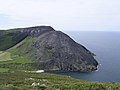
Cronk ny Arrey Laa is a hill in the south west of the Isle of Man. It may be confused with a hill of a similar name in the parish of Jurby, further north along the west coast of the island.
The Mountain Mile is a 1.3 mile section of a purpose-built graded road situated between the 27th and 29th Milestone roadside markers on the Snaefell Mountain Course used for the Isle of Man TT and Manx Grand Prix races on the A18 Mountain Road in the parish of Lezayre in the Isle of Man.

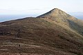
North Barrule is the second highest peak in the Isle of Man at 565 metres (1,854 ft). From the summit the northern plain of the Isle of Man can be viewed along with the coastlines of Ireland, Cumbria, Wales and Scotland.

Tower Bends is a point on the Snaefell Mountain Course used for the Isle of Man TT races on the Snaefell Mountain Road, designated A18, in the parish of Maughold in the Isle of Man.
The geology of the Isle of Man consists primarily of a thick pile of sedimentary rocks dating from the Ordovician period, together with smaller areas of later sedimentary and extrusive igneous strata. The older strata was folded and faulted during the Caledonian and Acadian orogenies The bedrock is overlain by a range of glacial and post-glacial deposits. Igneous intrusions in the form of dykes and plutons are common, some associated with mineralisation which spawned a minor metal mining industry.
| Authority control: National |
|---|