Cronk ny Arrey Laa

Last updated

Cronk ny Arrey Laa
Highest point
Elevation 437 m (1,434 ft)
Prominence 126 m (413 ft)  OOjs UI icon edit-ltr-progressive.svg
Naming
English translationHill of the Day Watch
Language of name Manx
Geography
Location Isle of Man

Cronk ny Arrey Laa is a hill in the south west of the Isle of Man. It may be confused with a hill of a similar name in the parish of Jurby, further north along the west coast of the island.

Contents

At 437 m (1,434 ft) it is the second highest hill in this part of the island, after the South Barrule, 2 miles (3 km) to the east. It is in the parish of Rushen, although the boundary with the parish of Patrick is only about 200 metres to the north of its summit.

Name

Lag ny Keeilley (hollow of the church) on Cronk ny Arrey Laa; the Manx language has had a substantial influence on the island's toponymy and nomenclature. Lag ny Keeilley, West slope of Cronk ny Arrey Laa - geograph.org.uk - 181312.jpg
Lag ny Keeilley (hollow of the church) on Cronk ny Arrey Laa; the Manx language has had a substantial influence on the island's toponymy and nomenclature.

Its name means Hill of the Day Watch due to it having been used as a look out post for invaders during the time of the Viking invasions. [1]

The hill is also known locally as Cronk ny Irree-Laa, meaning hill of the rising day or dawn. It was said that when the sun broke over this hill, it was a sign to the herring-fishers to shoot their nets.

Features

Its steep western slope rises directly out of the sea in a cliff.

The area surrounding it has also been described by Trail Magazine as "some of the wildest terrain on any British coast path". and by Manx National Heritage as "amongst the most spectacular to be seen anywhere in the British Isles." [2]

However, the summit is only about 500 metres from the main road between Port Erin/Port St Mary and Peel, and may be climbed as part of an easy day walk between those places. The summit is on the long-distance path, the Raad ny Foillan.

The summit is one of the few places anywhere with views of what Manx people call "the six kingdoms" (Mann, England, Scotland, Ireland, Wales, and Heaven), with some adding a seventh "kingdom", Neptune (the sea). The boggy slopes are home to unusual plant species such as the carnivorous sundew. [2]

Pilgrimage site

This is an ancient place of pilgrimage. Two particular sites on the slopes of Cronk ny Arrey Laa were visited: the "Chibbyr ny Vashtey" (well of baptism) and the Manx Keil (chapel) at Lag ny Keeilley on the steep western face. [2]

Related Research Articles

<span class="mw-page-title-main">Geography of the Isle of Man</span>

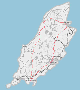
The Isle of Man is an island in the Irish Sea, between Great Britain and Ireland in Northern Europe, with a population of almost 85,000. It is a British Crown dependency. It has a small islet, the Calf of Man, to its south. It is located at 54°15′N4°30′W.

<span class="mw-page-title-main">Snaefell</span> Mountain on the Isle of Man

Snaefell – is the highest mountain and the only summit above 2,000 feet (610 m) on the Isle of Man, at 2,037 feet (620.9 m) above sea level. The summit is crowned by a railway station, cafe and several communications masts.

<span class="mw-page-title-main">Bradda Hill</span>

Bradda Hill is a headland some 2 kilometres (1.2 mi) north of the village of Port Erin on the Isle of Man. It is not to be confused with Bradda Head which is about 2 kilometres (1.2 mi) to the SW.

<span class="mw-page-title-main">Manx English</span> Historic dialect of English

Manx English, or Anglo-Manx, is the historic dialect of English spoken on the Isle of Man, though today in decline. It has many borrowings from Manx, a Goidelic language, and it differs widely from any other variety of English, including dialects from other areas in which Celtic languages are or were spoken, such as Welsh English and Hiberno-English.

<span class="mw-page-title-main">Michael, Isle of Man</span> Sheading of the Isle of Man

Michael is one of the six sheadings of the Isle of Man. It is located on the west of the island and consists of the three historic parishes of Ballaugh, Jurby and Michael.

<span class="mw-page-title-main">Rushen</span> Parish on the Isle of Man

Rushen, formally Kirk Christ Rushen, is one of the seventeen historic parishes of the Isle of Man.

<span class="mw-page-title-main">Santon, Isle of Man</span> Parish on the Isle of Man

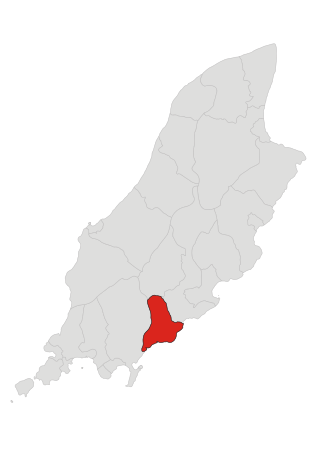
Santon, historically Santan, is one of the seventeen historic parishes of the Isle of Man.

<span class="mw-page-title-main">Highlander, Isle of Man</span>

Highlander is situated between the 5th and 6th Milestone road-side markers on the Snaefell Mountain Course used for the Isle of Man TT races on the primary A1 Douglas to Peel road in the parish of Marown in the Isle of Man.

<span class="mw-page-title-main">Highroads Course</span>

Highroads Course was a road-racing circuit used for the Gordon Bennett British Eliminating Trial held in the Isle of Man for the 1904 and 1905 Tourist Trophy Race involving touring automobiles and cars. The events were held on public roads closed for racing by an Act of Tynwald.

Laurel Bank is situated between the 10th Milestone and 11th Milestone road-side markers on the primary A3 Castletown to Ramsey Road between Ballacraine and Glen Helen in the parish of Kirk German in the Isle of Man.

<span class="mw-page-title-main">Raad ny Foillan</span> Long distance footpath in the Isle of Man

Raad ny Foillan is a coastal long-distance footpath in the Isle of Man. Because it is a closed loop around the coast, it can be walked in either a clockwise or an anti-clockwise direction.

<span class="mw-page-title-main">Sarah's Cottage, Isle of Man</span> Historic site in Sarahs Cottage, Kirk German

Sarah's Cottage is situated between the 11th milestone and 12th milestones on Creg Willey’s Hill on the primary A3 Castletown to Ramsey Road in the parish of Kirk German in the Isle of Man.

<span class="mw-page-title-main">Cronk-ny-Mona</span>

Cronk-ny-Mona is situated between the 36 and 37 mile markers used for the Snaefell Mountain Course, being on the primary A18 Mountain Road at the road junction with the A21 Johnny Watterson('s) Lane and the tertiary C10 Scholag Road in the Isle of Man parish of Onchan.

Cronk Urleigh is a stretch of road situated at the 15th Milestone on the primary A3 Castletown to Ramsey in the parish of Kirk Michael in the Isle of Man.

Cronk may refer to:

<span class="mw-page-title-main">North Barrule</span>

North Barrule is the second highest peak in the Isle of Man at 565 metres (1,854 ft). From the summit the northern plain of the Isle of Man can be viewed along with the coastlines of Ireland, Cumbria, Wales and Scotland.

<span class="mw-page-title-main">Hills and mountains of the Isle of Man</span>

The Isle of Man is mostly hilly, but has only one summit, Snaefell, classified as a mountain.

<span class="mw-page-title-main">John Moore Jeffcott</span> Manx politician

John Moore Jeffcott QC was a Manx advocate who became High Bailiff of Castletown and a Member of the House of Keys for the constituency of Castletown.

The geology of the Isle of Man consists primarily of a thick pile of sedimentary rocks dating from the Ordovician period, together with smaller areas of later sedimentary and extrusive igneous strata. The older strata was folded and faulted during the Caledonian and Acadian orogenies The bedrock is overlain by a range of glacial and post-glacial deposits. Igneous intrusions in the form of dykes and plutons are common, some associated with mineralisation which spawned a minor metal mining industry.

References

  1. Moore, Arthur William (1971). Folk-lore of the Isle of Man. Forgotten Books. p. 237. ISBN   1-60506-183-2.
  2. 1 2 3 "Home | Manx National Heritage : Celebrating the Isle of Man's History".

54°08′13″N4°43′05″W / 54.137°N 4.718°W / 54.137; -4.718