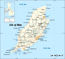
Raad ny Foillan

Last updated

Raad ny Foillan
Raad ny Foillan sign.jpg
Raad ny Foillan sign
Length102 mi (164 km)
Location Isle of Man
Designation National Trail
Trailheads Circular: Douglas
Use Hiking

Raad ny Foillan ( Manx for 'The Way of the Gull') is a coastal long-distance footpath in the Isle of Man. [1] Because it is a closed loop around the coast, it can be walked in either a clockwise or an anti-clockwise direction.

Contents

Route and history

The Raad ny Foillan starts and finishes at the Millennium Bridge over Douglas Harbour. The path, which is 102 miles (164 km) in length, forms a complete loop around the Manx coast, waymarked with signs showing a gull on a blue background.

The walk was created to mark the Island's "Heritage Year" celebrations in 1986 [ citation needed ] and generally follows the coast, passing through terrain varying from shingle beaches at the Ayres to over 1,400-foot-high (430 m) hills and cliffs.

The route comprises the following sections:

Isle of Man Isle of Man map-en.svg
Isle of Man

The Fastest Known Time (FKT) for the Raad ny Foillan is 21 hours, 21 minutes and 25 seconds, set by Orran Smith [2] (self-supported) in October 2020.

Flora and fauna

The coastal sections may provide sightings of seabirds such as kittiwakes, Manx shearwaters, puffins, guillemots and sea gulls together with grey seals, and at points inland the rare Manx Loaghtan sheep on areas protected by Manx National Heritage. [3]

See also

Related Research Articles

<span class="mw-page-title-main">Geography of the Isle of Man</span>

The Isle of Man is an island in the Irish Sea, between Great Britain and Ireland in Northern Europe, with a population of almost 85,000. It is a British Crown dependency. It has a small islet, the Calf of Man, to its south. It is located at 54°15′N4°30′W.

The Isle of Man has an extensive communications infrastructure consisting of telephone cables, submarine cables, and an array of television and mobile phone transmitters and towers.

<span class="mw-page-title-main">Laxey</span> Human settlement in the Isle of Man

Laxey is a village on the east coast of the Isle of Man. Its name derives from the Old Norse Laxa meaning 'Salmon River'. Its key distinguishing features are its three working vintage railways and the largest working waterwheel in the world. It is also the location of King Orry's Grave.

<span class="mw-page-title-main">Onchan</span> Human settlement in the United Kingdom

Onchan is a large village in the parish of Onchan on the Isle of Man. It is at the north end of Douglas Bay. Administratively a district, it has the second largest population of settlements on the island, after Douglas, with which it forms a conurbation.

<span class="mw-page-title-main">Ramsey, Isle of Man</span> Human settlement on the Isle of Man

Ramsey is a coastal town in the north of the Isle of Man. It is the second largest town on the island after Douglas. Its population is 7,845 according to the 2016 Census. It has one of the biggest harbours on the island, and has a prominent derelict pier, called the Queen's Pier. It was formerly one of the main points of communication with Scotland. Ramsey has also been a route for several invasions by the Vikings and Scots.

<span class="mw-page-title-main">Manx National Heritage</span> National heritage organisation of the Isle of Man

Manx National Heritage is the national heritage organisation for the Isle of Man. The organisation manages a significant proportion of the island’s physical heritage assets including over 3,000 acres of coastline and landscape. It holds property, archives, artwork, library and museum collections in trust for the Manx nation. It is the Isle of Man's statutory heritage agency and an Isle of Man registered charity (№ 603).

<span class="mw-page-title-main">Local government in the Isle of Man</span>

Local governmentin the Isle of Man was formerly based on six sheadings, which were divided into seventeen parishes. The island is today divided for local government purposes into town districts, village districts, parish districts, and "districts", as follows:

Barregarrow is a district located between the 13th milestone and 14th milestones on the A3 Castletown to Ramsey road including the area of the Barregarrow cross-road junction and the C4 Ballaleigh Road and B10 Sartfield (Brandywell) or former Barregarrow mountain gate road in the parish of Kirk Michael in the Isle of Man.

<span class="mw-page-title-main">Millennium Way</span> Long distance footpath on the Isle of Man

The Millennium Way is a long distance footpath on the Isle of Man. The path is approximately 28 miles (45 km) in length, stretching between Castletown and Ramsey.

<span class="mw-page-title-main">Ballabeg, Lonan</span> Human settlement in the United Kingdom

There are about eight small places on the Isle of Man with the name Ballabeg. The name Ballabeg derives from the Manx Balley Beg which means small homestead; although the spelling is different, it is pronounced approximately the same as the English name.

<span class="mw-page-title-main">Highroads Course</span>

Highroads Course was a road-racing circuit used for the Gordon Bennett British Eliminating Trial held in the Isle of Man for the 1904 and 1905 Tourist Trophy Race involving touring automobiles and cars. The events were held on public roads closed for racing by an Act of Tynwald.

<span class="mw-page-title-main">Outline of the Isle of Man</span> Overview of and topical guide to the Isle of Man

The following outline is provided as an overview of and topical guide to the Isle of Man:

Rhencullen including Birkin's Bend is adjacent to the 17th milestone of the TT course, on the primary A3 Castletown to Ramsey road in the Isle of Man.

Cronk ny Arrey Laa is a hill in the south west of the Isle of Man. It may be confused with a hill of a similar name in the parish of Jurby, further north along the west coast of the island.

Bayr ny Skeddan is a walking route in the Isle of Man between the towns of Castletown and Peel. It is about 14 miles (23 km) long, and reaches a maximum height of about 150 metres (490 ft) at the Round Table below the South Barrule.

The Isle of Man Football Association Cup is the foremost football cup competition for teams playing on the Isle of Man. The tournament, founded in 1889, features the twenty six teams from the Isle of Man Premier League and Division 2. The tournament is overseen by the Isle of Man Football Association.

The geology of the Isle of Man consists primarily of a thick pile of sedimentary rocks dating from the Ordovician period, together with smaller areas of later sedimentary and extrusive igneous strata. The older strata was folded and faulted during the Caledonian and Acadian orogenies The bedrock is overlain by a range of glacial and post-glacial deposits. Igneous intrusions in the form of dykes and plutons are common, some associated with mineralisation which spawned a minor metal mining industry.

References

  1. "Walking and Wildlife on the Isle of Man - Raad Ny Foillan (Road of the Gulls) - Isle of Man Government -". 17 April 2009. Archived from the original on 17 April 2009. Retrieved 8 May 2021.
  2. "Raad Ny Foillan (United Kingdom) | Fastest Known Time". fastestknowntime.com.
  3. Smith, Rory (15 June 2002). "Leg Man". The Guardian . Retrieved 18 December 2017.