Geography of Cyprus

Last updated

Cyprus
Cyprus sentinel2.jpg
Satellite image of Cyprus in 2022
Island of Cyprus (orthographic projection).svg
Location of Cyprus
Geography of Cyprus
Geography
Location Mediterranean Sea
Coordinates
35°N33°E / 35°N 33°E / 35; 33
Largest city Nicosia
Area9,251 km2 (3,572 sq mi)
Coastline648 km (402.6 mi)
Highest elevation1,952 m (6404 ft)
Highest point Mount Olympus
Administration
Capital and largest city Nicosia
Area covered5,896 km2(2,276 sq mi; 63.7%)
Turkish Republic of Northern Cyprus
(de facto northern administration, self-proclaimed and only recognised by Turkey)
Capital and largest city North Nicosia
Area covered3,355 km2(1,295 sq mi; 36.3%)
Capital and largest settlement Episkopi Cantonment
Area covered254 km2(98 sq mi; 2.7%)
Demographics
Population1,278,686 (2021)
Pop. density138/km2 (357/sq mi)
Ethnic groups

Cyprus is an island country in the Eastern Basin of the Mediterranean Sea. It is the third-largest island in the Mediterranean, after the Italian islands of Sicily and Sardinia, and the 80th-largest island in the world by area. It is located south of the Anatolian Peninsula, yet it belongs to the Cyprus Arc. [1] Geographically, Cyprus is located in West Asia, [2] but the country is considered a European country in political geography. [3] Cyprus also had lengthy periods of mainly Greek and intermittent Anatolian, Levantine, Byzantine, Turkish, and Western European influence.

Contents

The island is dominated by two mountain ranges, the Troodos Mountains and the Kyrenia Mountains or Pentadaktylos, and the central plain, the Mesaoria, between them. [4] The Troodos Mountains cover most of the southern and western portions of the island and account for roughly half its area. [4] The narrow Kyrenia Range extends along the northern coastline. [4] It is not as high as the Troodos Mountains, and it occupies substantially less area. [4] The two mountain ranges run generally parallel to the Taurus Mountains on the Turkish mainland, the outlines of which are visible from northern Cyprus. [4] Coastal lowlands, varying in width, surround the island. [4]

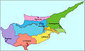
Geopolitically, the island is divided into four segments. The Republic of Cyprus, the only internationally recognized government, occupies the southern 60% of the island, and has been a member state of the European Union since 1 May 2004. The Turkish Republic of Northern Cyprus, is diplomatically recognized only by Turkey; it governs the northern one-third of the island, around 36% of the territory. The United Nations-controlled Green Line is a buffer zone that separates the two and it is about 4%. Lastly, two areas—Akrotiri and Dhekelia—remain under British sovereignty for military purposes, collectively forming the Sovereign Base Areas of Akrotiri and Dhekelia (SBA). The SBAs are located on the southern coast of the island and together encompass 254 km2, or 2.8% of the island.

Terrain

Skiriotissa mine Geology of Cyprus-SkiriotissaMine.jpg
Skiriotissa mine
This image, photographed from the International Space Station in 2013, shows the three distinct geologic regions of the island. In the central and western part of the island is the Troodos Massif, a mountain range whose surface layer is mostly basaltic lava rock, and whose maximum elevation is 1,952 m (6,404 ft). Running in a thin arc along the northeast margin of the island is Cyprus's second mountain range, a limestone formation called the Kyrenia Range. The space between these ranges is home to the capital Nicosia, visible as a grayish-brown patch near the image's centre. CyprusFromTheISS(cropped).jpg
This image, photographed from the International Space Station in 2013, shows the three distinct geologic regions of the island. In the central and western part of the island is the Troodos Massif, a mountain range whose surface layer is mostly basaltic lava rock, and whose maximum elevation is 1,952 m (6,404 ft). Running in a thin arc along the northeast margin of the island is Cyprus's second mountain range, a limestone formation called the Kyrenia Range. The space between these ranges is home to the capital Nicosia, visible as a grayish-brown patch near the image's centre.
Topography Cyprus topo.png
Topography
Detailed map of Cyprus Cyprus2022OSM.png
Detailed map of Cyprus

The rugged Troodos Mountains, whose principal range stretches from Pomos Point in the northwest almost to Larnaca Bay on the east, are the single most conspicuous feature of the landscape. [4] Intensive uplifting and folding in the formative period left the area highly fragmented, so that subordinate ranges and spurs veer off at many angles, their slopes incised by steep-sided valleys. [4] In the southwest, the mountains descend in a series of stepped foothills to the coastal plain. [4]

While the Troodos Mountains are a massif formed of molten igneous rock, the Kyrenia Range is a narrow limestone ridge that rises suddenly from the plains. [4] Its easternmost extension becomes a series of foothills on the Karpas Peninsula. [4] That peninsula points toward Asia Minor, to which Cyprus belongs geologically. [4] The Kyrenia Range is also known as the Pentadactylon Mountains, due to a summit resembling five fingers.

Even the highest peaks of the Kyrenia Range are hardly more than half the height of the great dome of the Troodos massif, Mount Olympus (1,952 m or 6,404 ft), [5] but their seemingly inaccessible, jagged slopes make them considerably more spectacular. [4] British writer Lawrence Durrell, in Bitter Lemons, wrote of the Troodos as "an unlovely jumble of crags and heavyweight rocks" and of the Kyrenia Range as belonging to "the world of Gothic Europe, its lofty crags studded with crusader castles." [4]

Rich copper deposits were discovered in antiquity on the slopes of the Troodos. [4] The massive sulphide deposits formed as a part of an ophiolite complex at a spreading centre under the Mediterranean Sea which was tectonically uplifted during the Pleistocene and emplaced in its current location. [6]

Drainage

In much of the island, access to a year-round supply of water is difficult. [4] This is traditionally attributed to deforestation which damaged the island's drainage system through erosion, [4] but Grove and Rackham question this view. [7] A network of winter rivers rises in the Troodos Mountains and flows out from them in all directions. [4] The Yialias River and the Pedhieos River flow eastward across the Mesaoria into Famagusta Bay; the Serraghis River flows northwest through the Morphou plain. [4] All of the island's rivers, however, are dry in the summer. [4] An extensive system of dams and waterways has been constructed to bring water to farming areas. [4]

The Mesaoria is the agricultural heartland of the island, but its productiveness for wheat and barley depends very much on winter rainfall; other crops are grown under irrigation. [4] Little evidence remains that this broad, central plain, open to the sea at either end, was once covered with rich forests whose timber was coveted by ancient conquerors for their sailing vessels. [4] The now-divided capital of the island, Nicosia, lies in the middle of this central plain. [4]

Natural vegetation

Cyprus countryside on the way to Troodos Mountains during the summer Cyprus countryside on the way to Troodos Mountains in the late summer Republic of Cyprus.jpg
Cyprus countryside on the way to Troodos Mountains during the summer

Despite its small size, Cyprus has a variety of natural vegetation. This includes forests of conifers and broadleaved trees such as pine ( Pinus brutia ), cedar, cypresses and oaks. Ancient authors write that most of Cyprus, even Messaoria, was heavily forested, and there are still considerable forests on the Troodos and Kyrenia ranges, and locally at lower altitudes. About 17% of the whole island is classified as woodland. Where there is no forest, tall shrub communities of golden oak ( Quercus alnifolia ), strawberry tree ( Arbutus andrachne ), terebinth ( Pistacia terebinthus ), olive ( Olea europaea ), kermes oak ( Quercus coccifera ) and styrax ( Styrax officinalis ) are found, but such maquis is uncommon. Over most of the island untilled ground bears a grazed covering of garrigue, largely composed of low bushes of Cistus, Genista sphacelata , Calicotome villosa , Lithospermum hispidulum, Phagnalon rupestre and, locally, Pistacia lentiscus . Where grazing is excessive this covering is soon reduced, and an impoverished batha remains, consisting principally of Thymus capitatus , Sarcopoterium spinosum , and a few stunted herbs.

Climate

Sandstorm in the Levant, October 19, 2002 Cyprus.A2002292.1045.500m.jpg
Sandstorm in the Levant, October 19, 2002

The Mediterranean climate, warm and rather dry, with rainfall mainly between November and March, favours agriculture. [4] In general, the island experiences mild wet winters and dry hot summers. [4] Variations in temperature and rainfall are governed by altitude and, to a lesser extent, distance from the coast. [4] Hot, dry summers from mid-May to mid-September and rainy, rather changeable winters from November to mid-March are separated by short autumn and spring seasons.
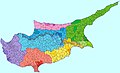
Area and boundaries

Area:
Total: 9,251 km2 (of which 5,896 km2 (2,276 sq mi) are under the control of the Republic of Cyprus and of which 3,355 km2 (1,295 sq mi) are under military occupation by Turkey)
Land: 9,241 km2
Water: 10 km2

Land boundaries: 0 km

Coastline: 648 km

Maritime claims:
Territorial sea:12  nmi (22.2 km; 13.8 mi)
Continental shelf: 200 m depth or to the depth of exploitation
Exclusive Economic Zone:98,707 km2 (38,111 sq mi)

Elevation extremes:
Lowest point: Mediterranean Sea 0 m
Highest point: Olympus 1,952 m [5]

Resource and land use

Natural resources: copper, pyrite, asbestos, gypsum, timber, salt, marble, clay earth pigment

Land use:
arable land: 9.90%
permanent crops: 3.24%
other: 86.86% (2012)

Irrigated land: 457.9 km2 (2007)

Total renewable water resources: 0.78 km3 (2011)

Freshwater withdrawal (domestic/industrial/agricultural):
total: 0.18 km3/yr (10%/3%/86%)
per capital: 164.7 m3/yr (2009)

Environmental concerns

Natural hazards: moderate earthquake activity; droughts

Environment – current issues: water resource problems (no natural reservoir catchments, seasonal disparity in rainfall, sea water intrusion to island's largest aquifer, increased salination in the north); water pollution from sewage and industrial wastes; coastal degradation; loss of wildlife habitats from urbanization.

Environment – international agreements:
party to: Air Pollution, Air Pollution-Persistent Organic Pollutants, Biodiversity, Climate Change, Climate Change-Kyoto Protocol, Endangered Species, Environmental Modification, Hazardous Wastes, Law of the Sea, Marine Dumping, Nuclear Test Ban, Ozone Layer Protection, Ship Pollution, Wetlands
signed, but not ratified: none

See also

Related Research Articles

<span class="mw-page-title-main">Cyprus</span> Mediterranean island country in the Middle East

Cyprus, officially the Republic of Cyprus, is an island country located in the eastern Mediterranean Sea, north of the Sinai Peninsula, south of the Anatolian Peninsula, and west of the Levant. It is geographically a part of West Asia, but its cultural ties and geopolitics are overwhelmingly Southeast European. Cyprus is the third-largest and third-most populous island in the Mediterranean. It is located east of Greece, north of Egypt, south of Turkey, and west of Lebanon and Syria. Its capital and largest city is Nicosia. The northeast portion of the island is de facto governed by the self-declared Turkish Republic of Northern Cyprus.

<span class="mw-page-title-main">Geography of Iraq</span> Geographic features of Iraq

The geography of Iraq is diverse and falls into five main regions: the desert, Upper Mesopotamia, the northern highlands of Iraq, Lower Mesopotamia, and the alluvial plain extending from around Tikrit to the Persian Gulf.

<span class="mw-page-title-main">Geography of Lebanon</span> Geographical features of Lebanon

Lebanon is a small country in the Eastern Mediterranean, located at approximately 34˚N, 35˚E. It stretches along the eastern shore of the Mediterranean Sea and its length is almost three times its width. From north to south, the width of its terrain becomes narrower. Lebanon's mountainous terrain, proximity to the sea, and strategic location at a crossroads of the world were decisive factors in shaping its history.

<span class="mw-page-title-main">Geography of Spain</span> Overview of the geography of Spain

Spain is a country located in southwestern Europe occupying most of the Iberian Peninsula. It also includes a small exclave inside France called Llívia, as well as the Balearic Islands in the Mediterranean, the Canary Islands in the Atlantic Ocean 108 km (67 mi) off northwest Africa, and five places of sovereignty on and off the coast of North Africa: Ceuta, Melilla, Islas Chafarinas, Peñón de Alhucemas, and Peñón de Vélez de la Gomera.

<span class="mw-page-title-main">Geography of Syria</span> Geographical features of Syria

Syria is located in West Asia, north of the Arabian Peninsula, at the eastern end of the Mediterranean Sea. It is bordered by Turkey to the north, Lebanon and Israel to the west and southwest, Iraq to the east, and Jordan to the south. It consists of mountain ranges in the west and a steep area inland. In the east is the Syrian Desert and in the south is the Jabal al-Druze Range. The former is bisected by the Euphrates valley. A dam built in 1973 on the Euphrates created a reservoir named Lake Assad, the largest lake in Syria. The highest point in Syria is Mount Hermon on the Lebanese border at 2,814 metres or 9,232 feet. Between the humid Mediterranean coast and the arid desert regions lies a semiarid steep zone extending across three-quarters of the country, which receives hot, dry winds blowing across the desert. Syria is extensively depleted, with 28 percent of the land arable, 4 percent dedicated to permanent crops, 46 percent utilized as meadows and pastures, and only 3 percent forest and woodland.

<span class="mw-page-title-main">Geography of Turkey</span> Overview of the geography of Turkey

The Anatolian side of Turkey is the largest portion in the country that bridges southeastern Europe and west Asia. East Thrace, the European portion of Turkey comprises 3% of the country and 10% of its population. East Thrace is separated from Asia Minor, the Asian portion of Turkey, by the Bosporus, the Sea of Marmara and the Dardanelles. İskilip, Çorum province, is considered to be the geographical center of Earth. Turkey is very vulnerable to earthquakes.

<span class="mw-page-title-main">Troodos Mountains</span> Mountain range in Cyprus

Troodos is the largest mountain range in Cyprus, located in roughly the center of the island. Its highest peak is Mount Olympus, also known as Chionistra, at 1,952 metres (6,404 ft), which hosts the Sun Valley and North Face ski areas with their five ski lifts.

<span class="mw-page-title-main">Kyrenia Mountains</span> Mountain range in Cyprus

The Kyrenia Mountains is a long, narrow mountain range that runs for approximately 160 km (100 mi) along the northern coast of the island of Cyprus. It is primarily made of hard crystalline limestone, with some marble. Its highest peak is Mount Selvili, at 1,024 m (3,360 ft). Pentadaktylos is another name for the Kyrenia Mountains, though Britannica refers to Pentadaktylos as the "western portion" of the latter, or the part west of Melounta. Pentadaktylos is so-named after one of its most distinguishing features, a peak that resembles five fingers.

<span class="mw-page-title-main">Mesaoria</span> Landform on the island of Cyprus

The Mesaoria is a broad, sweeping plain which makes up the north centre of the island of Cyprus.

<span class="mw-page-title-main">Mount Olympus (Cyprus)</span> Highest mountain in Cyprus

Olympus, or Chionistra, at 1,952 metres (6,404 ft), is the highest point in Cyprus. It is located in the Troodos Mountains of Cyprus. Mount Olympus peak and the "Troodos Square" fall under the territory of Platres in Limassol District. A British long range radar currently operates at Mount Olympus' peak. It has a highland warm-summer mediterranean climate.

<span class="mw-page-title-main">Pedieos</span> River in Cyprus

The Pedieos is the longest river in Cyprus. The river originates in the Troodos Mountains close to Machairas Monastery and flows northeast across the Mesaoria plains, through the capital city Nicosia. It then steers east, meeting the sea at Famagusta Bay close to the ancient Greek city of Salamis. Maximum depth is 10 meters.

<span class="mw-page-title-main">Mediterranean Basin</span> Region of lands around the Mediterranean Sea that have a Mediterranean climate

In biogeography, the Mediterranean Basin, also known as the Mediterranean Region or sometimes Mediterranea, is the region of lands around the Mediterranean Sea that have mostly a Mediterranean climate, with mild to cool, rainy winters and warm to hot, dry summers, which supports characteristic Mediterranean forests, woodlands, and scrub vegetation. It was a very important part of Mediterranean civilizations.

<span class="mw-page-title-main">Military operations during the Turkish invasion of Cyprus</span>

In 1974, Turkey invaded the northern portion of the Republic of Cyprus in response to a military coup taking place on the island, in attempt to annex the island to Greece. Turkey claimed that this was an intervention in accordance to Treaty of Guarantee. The invasion consisted of two major Turkish offensives, and involved air, land and sea combat operations. The Greek Cypriot armed forces attempted to resist and respond to the attacks as part of a coordinated defence plan which proved inadequate to deal with the forces that Turkey was able to bring to bear, and the war resulted in a ceasefire which persists until the present day.

<span class="mw-page-title-main">Outline of Cyprus</span> Overview of and topical guide to Cyprus

The following outline is provided as an overview of and topical guide to Cyprus:

<span class="mw-page-title-main">Sovereign Base Areas Customs and Immigration</span> Customs agency of the UKs Sovereign Base Areas

Sovereign Base Areas Customs and Immigration is a semi-autonomous branch of HM Revenue and Customs (HMRC) of the United Kingdom. It has jurisdiction over Akrotiri and Dhekelia, a British Overseas Territory on the island of Cyprus, administered as a Sovereign Base Area, and home to British Forces Cyprus. It is managed by the Ministry of Defence (MoD) and around 3,500 military personnel are posted there at any one time.

<span class="mw-page-title-main">Geography of Greece</span>

Greece is a country in Southeastern Europe, on the Balkan Peninsula. It is bordered to the north by Albania, North Macedonia and Bulgaria; to the east by Turkey, and is surrounded to the east by the Aegean Sea, to the south by the Cretan and the Libyan seas, and to the west by the Ionian Sea which separates Greece from Italy.

<span class="mw-page-title-main">Postal codes in Cyprus</span>

Four digit post codes were introduced in Cyprus on 1 October 1994. The system is organised around the six administrative districts for local government on the island, with each district allocated a numerical range. Most of the four digit numbers are allocated to small geographic areas, such as streets, urban communes or villages, although some are reserved for government use.

<span class="mw-page-title-main">Climate of Cyprus</span> Climate of the Mediterranean island

Cyprus has a subtropical climate - Mediterranean and semi-arid type - according to Köppen climate classification signes Csa and BSh, with very mild winters and warm to hot summers. Snow is possible only in the Troodos mountains in the central part of the island. Rain occurs mainly in winter, with summer being generally dry.

<span class="mw-page-title-main">Turkey–Northern Cyprus water pipeline</span> International water supply pipeline

The Turkey–Northern Cyprus water pipeline was built by the Turkish Republic of Northern Cyprus Water Supply Project which was an international water diversion project designed to supply water for drinking and irrigation from southern Turkey to Northern Cyprus via pipeline under Mediterranean Sea. The pipeline was completed in September 2014. As such, the project is unique in the world.

<span class="mw-page-title-main">Cyprus Mediterranean forests</span>

The Cyprus Mediterranean forests is a terrestrial ecoregion that encompasses the island of Cyprus.

References

  1. "Shimon Wdowinski: Research: Eastern Mediterranean". faculty.fiu.edu.
  2. UNSD: M49 Standard
  3. The CIA World Factbook: Cyprus
  4. 1 2 3 4 5 6 7 8 9 10 11 12 13 14 15 16 17 18 19 20 21 22 23 24 25 26 27 Solsten, Eric, ed. (1993). Cyprus: a country study (4th ed.). Washington, D.C.: Federal Research Division, Library of Congress. pp. 50–53. ISBN   0-8444-0752-6. OCLC   27014039. PD-icon.svg This article incorporates text from this source, which is in the public domain.{{cite encyclopedia}}: CS1 maint: postscript (link)
  5. 1 2 "Country Profile: Climate". Official Website of the Embassy of the Republic of Cyprus in Washington D.C. Archived from the original on 2012-02-05. Retrieved 2006-10-11.
  6. http://www.moa.gov.cy/moa/gsd/gsd.nsf/dmlTroodos_en/dmlTroodos_en?OpenDocument Archived 2017-01-18 at the Wayback Machine Cyprus Geologic Survey
  7. A.T. Grove, Oliver Rackham, The Nature of Mediterranean Europe: An Ecological History, Yale, 2001. ISBN   0-300-08443-9.

Attribution: