Geography of Oman

Last updated

Geography of Oman
Oman Topography.png
ContinentAsia
RegionWest Asia
Coordinates 21°00′N57°00′E / 21.000°N 57.000°E / 21.000; 57.000
Area Ranked 70th
  Total309,500 km2 (119,500 sq mi)
  Land100%
  Water0%
Coastline3,165 km (1,967 mi)
Borders Saudi Arabia: 676 km (420 mi)
UAE: 410 km (250 mi)
Yemen: 288 km (179 mi)
Natural resourcespetroleum, copper, asbestos, Limited marble, limestone, chromium, gypsum, natural gas
Natural hazardsLarge sandstorms in interior in summer; large floods after rains; tropical cyclones
Environmental issues Soil salinity rising; oil spills; very limited fresh water resources
Exclusive economic zone533,180 km2 (205,862 sq mi)

Oman is a country on the southeast coast of the Arabian Peninsula, situated in West Asia, bordering the Arabian Sea, Gulf of Oman, and Persian Gulf, between Yemen and the United Arab Emirates (UAE). The coast of Oman was an important part in the Omani empire and sultanate.

Contents

Location

Oman is located in the southeastern quarter of the Arabian Peninsula and covers a total land area of 309,500 km2 (119,500 sq mi). The land area is composed of varying topographic features: valleys and desert account for 82 percent of the land mass; mountain ranges, 15 percent; and the coastal plain, 3 percent. The sultanate is flanked by the Gulf of Oman, the Arabian Sea, and the Rub' al Khali (Empty Quarter) of Saudi Arabia, all of which contributed to Oman's isolation. Historically, the country's contacts with the rest of the world were by sea, which not only provided access to foreign lands but also linked the coastal towns of Oman. The Rub' al-Khali, difficult to cross even with modern desert transport, formed a barrier between the sultanate and the Arabian interior. The Hajar Mountains, [1] [2] which form a belt between the coast and the desert from the Musandam Peninsula (Ras Musandam) to the city of Sur, almost at Oman's easternmost point, [3] formed another barrier. These geographic barriers kept the interior of Oman free from foreign military encroachments. The southwestern corner of Oman's exclusive economic zone is situated a few miles off the Puntland-adjacent Yemeni archipelago of Socotra, which lies amidst the Guardafui Channel and the Somali Sea to the south. [4]

Geographical regions
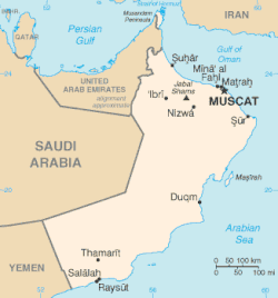
Map of Oman Oman Map FBOI.gif
Map of Oman
Detailed map of Oman Oman 1996 CIA map.jpg
Detailed map of Oman

Natural features divide the country into six distinct areas: Ru'us al-Jibal, including the northern Musandam Peninsula; [5] the Batinah plain running southeast along the Gulf of Oman coast; [2] the Oman interior behind the Batinah coast comprising the Hajar Mountains, their foothills, and desert fringes; the coast from Muscat-Matrah around the point of Ras Al Hadd, [2] and down the Arabian Sea; the offshore island of Masirah; and finally the barren coastline south to the Dhofar region in the south.

Except for the foggy and fertile Dhofar, all of the coast and the lowlands around the Hajar mountains are part of the Gulf of Oman desert and semi-desert ecoregion, while the mountains themselves are a distinct habitat.

Musandam Governorate

The northernmost area, Musandam, extends from the tip of the Musandam Peninsula to the boundary with the United Arab Emirates (UAE) at Hisn al-Dibba. It borders the Strait of Hormuz, which links the Persian Gulf with the Gulf of Oman, and is separated from the rest of the sultanate by a strip of territory belonging to the UAE. This area consists of low mountains forming the northernmost extremity of the Western Hajar. [5] Two inlets, Elphinstone (Khawr ash-Shamm) and Malcom (Ghubbat al-Ghazirah), cleave the coastline about one third of the distance from the Strait of Hormuz and at one point are separated by only a few hundred meters of land. The coastline is extremely rugged, and the Elphinstone Inlet, 16 kilometres (9.9 miles) long and surrounded by cliffs 1,000 to 1,250 m (3,280 to 4,100 ft) high, has frequently been compared with fjords in Norway.

Al-Batinah

The UAE territory separating Ru'us al Jibal from the rest of Oman extends almost as far south as the coastal town of Shinas. A narrow, well-populated coastal plain known as Al-Batinah [2] runs from the point at which the sultanate is re-entered to the town of As-Sib, about 140 km (87 mi) to the southeast. Across the plains, a number of wadis, heavily populated in their upper courses, descend from the Western Hajar Mountains to the south. A ribbon of oases, watered by wells and underground channels (aflaj), extends the length of the plain, about 10 km (33,000 ft) inland.

Muscat-Matrah coastal area

South of As Sib, the coast changes character. For about 175 km (109 mi), from As-Sib to Ras al-Hadd, it is barren and bounded by cliffs almost its entire length; there is no cultivation and little habitation. Although the deep water off this coast renders navigation relatively easy, there are few natural harbors or safe anchorages. The two best are at Muscat and Matrah, where natural harbors facilitated the growth of cities centuries ago.

Al-Sharqiyah

Al Sharqiyah is the northeastern region of the Sultanate of Oman and overlooks the Arabian Sea to the east and includes the inner side of the Eastern Hijr Mountains.
The region consists of the following governorates:

  1. South Al Sharqiyah: The province of Sur is its administrative capital in addition to the provinces of Jalan Bani Bu Ali and Jalan Bani Bu Hassan, Kamel and Alwafi and Masirah.
  2. North Al Sharqiyah: The province of Ibra is its administrative capital in addition to the provinces of Bidiyah, Al-Mudhaibi, Qabil, Wadi Bani Khalid, Damma and Al-Tayyeen.

Coastal tract, and island of Masirah

The desolate coastal tract from Jalan to Ras Naws has no specific name. Low hills and wastelands meet the sea for long distances. Midway along this coast and about fifteen kilometers offshore is the barren Masirah Island. Stretching about 70 km (43 mi), the island occupies a strategic location near the entry point to the Gulf of Oman from the Arabian Sea. Because of its location, it became the site of military facilities used first by the British and then by the United States, following an access agreement signed in 1980 by the United States and Oman.

Oman Governorate

West of the coastal areas lies the tableland of central Oman. The Wadi Samail (the largest wadi in the mountain zone),[ citation needed ] a valley that forms the traditional route between Muscat and the interior divides the Hajar range into two subranges: Al-Ḥajar Al-Gharbī (The Western Hajar) and Al-Ḥajar Ash-Sharqī (The Eastern Hajar). [2] At the same time, mountains in the central region, where the highest of the Hajar are located, are recognised as the "Central Hajar". [6] The general elevation is about 1,200 m (3,900 ft), but the peaks of the high ridge known as Jebel Akhdar ("Green Mountain"), rise to more than 3,000 m (1.9 mi). Jabal Akhdar is a home of the Arabian tahr, a unique species of wild goat. In the hope of saving this rare animal, Sultan Qabus ibn Said has declared part of the mountain a national park. Behind the Western Mountains are two inland regions, Az-Zahirah and Inner Oman, separated by the lateral range of the Rub al Khali. Adjoining the Eastern Hajar Mountains are the sandy regions of Ash-Sharqiyah and Jalan, which also border the desert.

Dhofar Governorate

Dhofar region extends from Ras ash-Sharbatat to the border of Yemen and north to the clearly defined border with Saudi Arabia. Its capital, Salalah, was the permanent residence of Sultan Said ibn Taimur Al Said and the birthplace of the present sultan, Qaboos ibn Said. The highest peak of the Dhofar Mountains, Jabal Samhan, is about 2,000 metres (1.2 miles). [7] The coast of Dhofar is fertile, being watered by monsoonal fogs from the Indian Ocean and is part of the Arabian Peninsula coastal fog desert ecoregion.

Al Dharerah region consists of three parts: Dhank, Ibri and Yanqul.[ citation needed ]

Climate

Oman Koppen climate classification map Koppen-Geiger Map OMN present.svg
Oman Köppen climate classification map
SeaWiFS captured this dust cloud blowing out over the Arabian Sea from Oman. 12 March 2000 Dust storm in Oman.jpg
SeaWiFS captured this dust cloud blowing out over the Arabian Sea from Oman. 12 March 2000
Oman is the fourteenth most water stressed country in the world. Water Stress, Top Countries (2020).svg
Oman is the fourteenth most water stressed country in the world.

According to the Köppen climate classification, Oman has four different climates (BWh, BWk, BSk, BSh), however is highly dominated by the BWh (hot desert) climate.

With the exception of Dhofari region, which has a strong monsoon climate and receives warm winds from the Indian Ocean, the climate of Oman is extremely hot and dry most of the year.

Summer begins in March and lasts until September. The highest temperatures are registered in the interior, where readings up to a maximum of 50.8 °C (123.4 °F) have been recorded.[ citation needed ] On the Batinah coastal plain, summer temperatures seldom exceed 47 °C (116.6 °F), but, because of the low elevation, the humidity may be as high as 90 percent. The mean summer temperature in Muscat is 33 °C (91.4 °F), but the gharbī (Arabic : غَرْبِي, lit. 'western'), a strong wind that blows from the Rub' al-Khali, can raise temperatures from the towns on the Gulf of Oman by 6 °C (10.8 °F) to 10 °C (18 °F).

Winter temperatures in December and January are mild and pleasant, ranging between 18 and 26 °C (64.4 and 78.8 °F).[ citation needed ]

Precipitation on the coasts and on the interior plains ranges from 20 to 100 millimeters (0.8 to 3.9 in) a year and falls during mid- and late winter. Rainfall in the mountains, particularly over Jebel Akhdar, is much higher and may reach 900 millimeters (35.4 in).

Because the plateau of Jebel Akhdar is porous limestone, rainfall seeps quickly through it, and the vegetation, which might be expected to be more lush, is meager. However, a huge reservoir under the plateau provides springs for low-lying areas. In addition, an enormous wadi channels water to these valleys, making the area agriculturally productive in years of good rainfall.

Dhofar, benefiting from a southwest monsoon between June and September, receives heavier rainfall and has constantly running streams, which make the region Oman's most fertile area.

Occasionally, a cyclone from the North Indian Ocean makes landfall, bringing with it heavy rain, such as Cyclone Kelia did in 2011. Oman was hit by Cyclone Gonu on 6 June. Large areas in the capital area region in the Governorate of Muscat and in Amerat and Quriyat were severely affected. Gonu first hit the southern city of Sur late on 5 June 2007. [8] Cyclone Mekunu is the strongest and only Major Cyclone to make Landfall in the nation and Whole Arabian Peninsula.

Climate data for Muscat
MonthJanFebMarAprMayJunJulAugSepOctNovDecYear
Record high °C (°F)34.6
(94.3)
38.2
(100.8)
41.5
(106.7)
44.9
(112.8)
48.3
(118.9)
48.5
(119.3)
49.1
(120.4)
49.2
(120.6)
47.2
(117.0)
43.6
(110.5)
39.4
(102.9)
37.8
(100.0)
49.2
(120.6)
Mean daily maximum °C (°F)25.5
(77.9)
26.1
(79.0)
29.8
(85.6)
34.7
(94.5)
39.5
(103.1)
40.4
(104.7)
38.6
(101.5)
36.2
(97.2)
36.3
(97.3)
35.0
(95.0)
30.5
(86.9)
27.1
(80.8)
33.3
(92.0)
Daily mean °C (°F)21.3
(70.3)
21.9
(71.4)
25.2
(77.4)
29.8
(85.6)
34.2
(93.6)
35.2
(95.4)
34.3
(93.7)
32.0
(89.6)
31.4
(88.5)
29.7
(85.5)
25.7
(78.3)
22.6
(72.7)
28.6
(83.5)
Mean daily minimum °C (°F)17.3
(63.1)
17.6
(63.7)
20.7
(69.3)
24.7
(76.5)
29.1
(84.4)
30.6
(87.1)
30.4
(86.7)
28.4
(83.1)
27.5
(81.5)
24.9
(76.8)
20.9
(69.6)
18.9
(66.0)
24.3
(75.7)
Record low °C (°F)1.6
(34.9)
2.3
(36.1)
7.0
(44.6)
10.3
(50.5)
17.2
(63.0)
21.6
(70.9)
23.5
(74.3)
21.3
(70.3)
19.0
(66.2)
14.3
(57.7)
9.4
(48.9)
4.5
(40.1)
1.6
(34.9)
Average precipitation mm (inches)12.8
(0.50)
24.5
(0.96)
15.9
(0.63)
17.1
(0.67)
7.0
(0.28)
0.9
(0.04)
0.2
(0.01)
0.8
(0.03)
0.0
(0.0)
1.0
(0.04)
6.8
(0.27)
13.3
(0.52)
100.3
(3.95)
Average relative humidity (%)63645845424960676355606558
Mean monthly sunshine hours 268.6244.8278.3292.5347.4325.7277.7278.6303.9316.9291.9267.03,493.3
Source: NOAA (1961–1990) [9]
Climate data for Salalah
MonthJanFebMarAprMayJunJulAugSepOctNovDecYear
Record high °C (°F)32.3
(90.1)
33.8
(92.8)
36.7
(98.1)
43.6
(110.5)
42.3
(108.1)
43.0
(109.4)
32.7
(90.9)
31.3
(88.3)
33.0
(91.4)
40.1
(104.2)
37.4
(99.3)
34.2
(93.6)
43.6
(110.5)
Mean daily maximum °C (°F)27.5
(81.5)
27.9
(82.2)
29.9
(85.8)
31.7
(89.1)
32.4
(90.3)
31.8
(89.2)
28.4
(83.1)
27.3
(81.1)
29.0
(84.2)
30.5
(86.9)
30.8
(87.4)
28.7
(83.7)
29.7
(85.4)
Daily mean °C (°F)22.9
(73.2)
23.7
(74.7)
25.5
(77.9)
27.6
(81.7)
29.0
(84.2)
29.0
(84.2)
26.4
(79.5)
25.2
(77.4)
26.3
(79.3)
26.3
(79.3)
25.9
(78.6)
23.9
(75.0)
26.0
(78.7)
Mean daily minimum °C (°F)17.9
(64.2)
19.2
(66.6)
21.0
(69.8)
23.4
(74.1)
25.6
(78.1)
26.5
(79.7)
24.2
(75.6)
23.1
(73.6)
23.4
(74.1)
21.6
(70.9)
20.4
(68.7)
18.8
(65.8)
22.1
(71.8)
Record low °C (°F)12.6
(54.7)
10.8
(51.4)
14.5
(58.1)
18.0
(64.4)
20.6
(69.1)
23.5
(74.3)
21.9
(71.4)
20.5
(68.9)
19.1
(66.4)
16.5
(61.7)
15.0
(59.0)
14.1
(57.4)
10.8
(51.4)
Average precipitation mm (inches)2.2
(0.09)
7.0
(0.28)
6.3
(0.25)
19.8
(0.78)
17.1
(0.67)
10.6
(0.42)
24.6
(0.97)
24.5
(0.96)
4.1
(0.16)
4.1
(0.16)
9.6
(0.38)
1.1
(0.04)
131
(5.16)
Average relative humidity (%)50586268758089908167555069
Mean monthly sunshine hours 289.6256.8297.6308.3335.1199.543.942.4188.0314.7304.7296.82,877.4
Source: NOAA (period of record varies, see source) [10]

Area and boundaries

Resources and land use

Environment

See also

Related Research Articles

<span class="mw-page-title-main">Oman</span> Country in West Asia

Oman, officially the Sultanate of Oman, is a country located in West Asia. It is situated on the southeastern coast of the Arabian Peninsula, and spans the mouth of the Persian Gulf. It shares land borders with Saudi Arabia, United Arab Emirates, and Yemen, while sharing maritime borders with Iran and Pakistan. The capital and largest city is Muscat. Oman has a population of nearly 4.7 million and is ranked the 124th most-populous country. The coast is formed by the Arabian Sea on the southeast, and the Gulf of Oman on the northeast. The Madha and Musandam exclaves are surrounded by United Arab Emirates on their land borders, with the Strait of Hormuz and the Gulf of Oman forming Musandam's coastal boundaries.

<span class="mw-page-title-main">Geography of the United Arab Emirates</span> List of the United Arab Emirates geographical features

The United Arab Emirates is situated in the Middle East and West Asia, bordering the Gulf of Oman and the Persian Gulf, between Oman and Saudi Arabia; it is at a strategic location along the northern approaches to the Strait of Hormuz, a vital transit point for world crude oil. The UAE lies between 22°50′ and 26° north latitude and between 51° and 56°25′ east longitude. It shares a 19 km (12 mi) border with Qatar on the northwest, a 530 km (330 mi) border with Saudi Arabia on the west, south, and southeast, and a 450 km (280 mi) border with Oman on the southeast and northeast.

<span class="mw-page-title-main">Muscat</span> Capital and largest city of Oman

Muscat is the capital and most populated city in Oman. It is the seat of the Governorate of Muscat. According to the National Centre for Statistics and Information (NCSI), the total population of Muscat Governorate was 1.72 million as of September 2022. The metropolitan area spans approximately 3,500 km2 (1,400 sq mi) and includes six provinces called wilayats, making it the largest city in the Arabian Peninsula by area. Known since the early 1st century AD as an important trading port between the west and the east, Muscat was ruled by various indigenous tribes as well as foreign powers such as the Persians, the Portuguese Empire and the Ottoman Empire at various points in its history. A regional military power in the 18th century, Muscat's influence extended as far as East Africa and Zanzibar. As an important port-town in the Gulf of Oman, Muscat attracted foreign traders and settlers such as the Persians, Balochs and Sindhis. Since the accession of Qaboos bin Said as Sultan of Oman in 1970, Muscat has experienced rapid infrastructural development that has led to the growth of a vibrant economy and a multi-ethnic society. Muscat is termed as a Beta - Global City by the Globalization and World Cities Research Network.

<span class="mw-page-title-main">Jebel Akhdar (Oman)</span> Peak in the Hajar Mountains range

The Jebel Akhdar is one of the Hajar Mountains in Ad Dakhiliyah Governorate of Oman. It rises to a height of 2,980 m (9,780 ft) and encompasses the Saiq Plateau at 2,000 m (6,600 ft) above sea level. Jebel Akhdar is famous for its labyrinth of wadis and terraced orchards, where pomegranates, apricots and roses grow in abundance due to its mild Mediterranean climate. Nearby is Jabal Shams, the highest peak in Oman and the Hajar range.

<span class="mw-page-title-main">Dhofar Governorate</span> Governorate of Oman

The Dhofar Governorate is the largest of the 11 governorates in the Sultanate of Oman in terms of area. It lies in southern Oman, on the eastern border with Yemen's Al Mahrah Governorate and the southern border with Saudi Arabia's Eastern Province. It is a rather mountainous area that covers 99,300 km2 (38,300 sq mi) and had a population of 416,458 at the 2020 census. The largest city and capital is Salalah. Historically, the region was a source of frankincense. The local dialect of Arabic is Dhofari Arabic, which is distinct from that used in the rest of Oman and in Yemen.

<span class="mw-page-title-main">Ash Sharqiyah Region (Oman)</span> Place in Ash-Sharqiyyah, Oman

Ash-Sharqiyyah Region was the eastern minṭaqah (region) of the Sultanate of Oman. The capital of Ash-Sharqiyyah is Sur. On 28 October 2011 Ash Sharqiyah Region was split into Ash Sharqiyah North Governorate and Ash Sharqiyah South Governorate.

<span class="mw-page-title-main">Sultan of Oman's Armed Forces</span> Combined armed forces of Oman

The Sultan of Oman's Armed Forces are the Royal Army of Oman, Royal Navy of Oman, Royal Air Force of Oman, Sultan's Special Force and other defense forces of the Sultanate of Oman. Since their formal establishment in the early 1950s, with British assistance SAF has twice overcome insurgencies which have threatened the integrity or social structure of the state, and more recently have contributed contingents or facilities to coalitions formed to protect Arab states of the Persian Gulf.

<span class="mw-page-title-main">Musandam Governorate</span> Governorate of Oman

The Musandam Governorate is a governorate of Oman. With the exception of the exclave of Madha, it is located on the Musandam Peninsula, which juts into the Strait of Hormuz, the narrow entry into the Persian Gulf, from the Arabian Peninsula. The governorate is also an exclave, separated from the rest of Oman by the United Arab Emirates. Its location gives Oman partial control, shared with Iran, of the strategic strait. In the northern section of Musandam, around Kumzar, the language is Kumzari, which is a southwestern Iranian language closely related to Larestani and Luri. The Musandam Peninsula has an area of 1,800 km2 (690 sq mi) and, at the 2020 census, a population of 49,062.

<span class="mw-page-title-main">Musandam Peninsula</span> Place

The Musandam Peninsula, locally known as Ruus Al Jibal, is a peninsula that forms the northeastern point of the Arabian Peninsula. It is located to the south of the Strait of Hormuz, between the Persian Gulf and the Gulf of Oman. It is inhabited by the Shihuh tribe and is mainly governed by Oman as the Musandam Governorate with certain parts governed by the United Arab Emirates, including Ras Al Khaimah and parts of Dibba.

<span class="mw-page-title-main">Provinces of Oman</span> Overview of the provinces of Oman

The administrative division of Oman contains eleven governorates (muhafazah):

<span class="mw-page-title-main">Al Batinah Region</span> Governorate in Oman

Al-Bāţinah was one of the regions (Mintaqat) of Oman. On 28 October 2011, Al-Batinah Region was bifurcated into Al Batinah North Governorate and Al Batinah South Governorate.

<span class="mw-page-title-main">Sur, Oman</span> City in Ash Sharqiyah Region, Oman

Sur is the capital city of Ash Sharqiyah South Governorate, and the former capital of Ash Sharqiyah Region in northeastern Oman, on the coast of the Gulf of Oman. It is located about 126 mi (203 km) southeast of the Omani capital Muscat. Historically, the city has been known for being an important destination point for sailors. Today, the sea still remains an important part of life in Sur.

<span class="mw-page-title-main">Samail</span> Settlement and valley in Oman

Samāʾil is a Wilayah (Province) located in Ad Dakhiliyah Region of the Sultanate of Oman. It is surrounded by a range of towering mountains, and its valley, Wadi Samail, is approximately 50 kilometres away from the capital of Muscat. The population is around 40,000 people, spread across 55 villages and towns.

<span class="mw-page-title-main">Imamate of Oman</span> Historical region in eastern and central Oman

The Imamate of Oman was a historical state within the Oman proper in the Hajar Mountains, part of the present-day Sultanate of Oman. The capital of the Imamate alternated historically between Rustaq and Nizwa. The Imamate's territory extended north to Ibri and south to the Alsharqiyah region and the Sharqiya Sands. The Imamate was bounded in the east by the Hajar Mountains and in the west by the Rub' al Khali desert. The Al Hajar Mountains separated the Imamate of Oman from Muscat and Oman. The elected Imam (ruler) resided in the capital, and Walis (governors) represented the Imamate in its different regions.

<span class="mw-page-title-main">Gulf of Oman desert and semi-desert</span>

The Gulf of Oman desert and semi-desert is a coastal ecoregion on the Persian Gulf and the Gulf of Oman in Oman and the United Arab Emirates at the northeastern tip of the Arabian Peninsula. The climate is hot and dry, with gravelly plains and savanna with thorny acacia trees inland from the coast. Along the coast there are mixture of habitats that include mangrove swamps, lagoons and mudflats. The mangrove areas are dominated by Avicennia marina and the savanna by Prosopis cineraria and Vachellia tortilis. Masirah Island is an important breeding area for the loggerhead sea turtle and other sea turtles also occur here, as well as a great variety of birds, some resident and some migratory. There are some protected areas, but in general the habitats have been degraded by the grazing of livestock, especially camels and goats; they are also at risk from oil spills, off-road driving and poaching.

<span class="mw-page-title-main">Hajar Mountains</span> Mountain range in Oman and the UAE

The Hajar Mountains are one of the highest mountain ranges in the Arabian Peninsula, shared between northern Oman and eastern United Arab Emirates. Also known as "Oman Mountains", they separate the low coastal plain of Oman from the high desert plateau, and lie 50–100 km (31–62 mi) inland from the Gulf of Oman.

<span class="mw-page-title-main">Wildlife of the United Arab Emirates</span>

The wildlife of the United Arab Emirates is the flora and fauna of the country on the eastern side of the Arabian Peninsula and the southern end of the Persian Gulf. The country offers a variety of habitats for wildlife including the coast, offshore islands, mangrove areas, mudflats, salt pans, sand and gravel plains, sand dunes, mountain slopes, wadis and rocky summits. Because the terrain is so varied, it supports a greater number of species of plants and animals than might have been expected in this relatively small country.

<span class="mw-page-title-main">Wildlife of Oman</span>

The wildlife of Oman is the flora and fauna of this country in the southeastern corner of the Arabian Peninsula, with coasts on the Gulf of Oman and the Arabian Sea. The climate is hot and dry, apart from the southeastern coast, and the country offers a variety of habitats for wildlife including mountains, valleys, deserts, coastal plains and sea coasts.

Wadi Qor is a seasonal watercourse in the Hajar Mountains of Ras Al Khaimah, in the United Arab Emirates. The wadi runs from the mountain village of Al Qor, near the Dubai exclave of Hatta, through the villages of Huwaylat, Rafaq and Al Nasla before crossing the Omani border and fanning out to the Batinah plain and the Gulf of Oman north of the Omani coastal village of Bu Baqarah.

<span class="mw-page-title-main">Al Hajar montane woodlands</span> Terrestrial ecoregion in Oman and the United Arab Emirates

Al Hajar montane woodlands is a temperate grasslands, savannas and shrublands ecoregion in the Hajar Mountains of the eastern part of the Arabian Peninsula, which extends across portions of Oman and the U.A.E.

References

  1. Allen, Calvin H. Jr. (5 February 2016). "1: Land and People". Oman: the Modernization of the Sultanate. Abingdon, New York City: Routledge. pp. 1–8. ISBN   978-1-3172-9164-0.
  2. 1 2 3 4 5 Cavendish, Marshall (2007). World and Its Peoples. Vol. 1. Cavendish Square Publishing. p. 11. ISBN   978-0-7614-7571-2.
  3. "The Eastern Hajar Mountains". Arabic Felix. Retrieved 17 January 2019.
  4. Jabado, Rima W., et al. "Troubled waters: Threats and extinction risk of the sharks, rays and chimaeras of the Arabian Sea and adjacent waters." Fish and Fisheries 19.6 (2018): 1043–1062.
  5. 1 2 Lancaster, Fidelity; Lancaster, William (2011). Honour is in Contentment: Life Before Oil in Ras Al-Khaimah (UAE) and Some Neighbouring Regions. Berlin, New York City: Walter de Gruyter. pp. 3–598. ISBN   978-3-1102-2339-2.
  6. Cullen, Katherine E.; Kusky, Timothy M. (2010). "Arabian geology". Encyclopedia of Earth and Space Science. New York City: Infobase Publishing. pp. 26–38. ISBN   978-1-4381-2859-7.
  7. "Samhan Mountain". Ministry of Tourism, Sultanate of Oman. Retrieved 14 January 2019.
  8. "Free the week" (PDF).
  9. "Seeb Climate Normals 1961-1990". National Oceanic and Atmospheric Administration . Retrieved 19 December 2012.
  10. "Salalh Climate Normals". National Oceanic and Atmospheric Administration . Retrieved 16 January 2013. (HTTPS version Retrieved March 7, 2022)
  11. The Oman National Spatial Strategy (ONSS) deals with these issues at a national scale, and its under development by Consatt limited with the participation of IE Professor and economist, Hermenegildo Seisdedos. ONSS Oman National Spatial Strategy Archived 29 July 2016 at the Wayback Machine . freiland.at