Outline of Cyprus

Last updated
The location of Cyprus LocationCyprus.svg
The location of Cyprus
Flag-map of Cyprus Flag-map of Cyprus.svg
Flag-map of Cyprus
An enlargeable map of the Republic of Cyprus Un-cyprus.png
An enlargeable map of the Republic of Cyprus
An enlargeable political map of the island of Cyprus Cyprus districts named.png
An enlargeable political map of the island of Cyprus

The following outline is provided as an overview of and topical guide to Cyprus:

Contents

Cyprus Eurasian island country located in the Eastern Mediterranean Sea, east of Greece, south of Turkey, west of Syria and Lebanon, northwest of Israel and north of Egypt. Cyprus is the third largest island in the Mediterranean Sea and the Republic of Cyprus is a member state of the European Union.

General reference

A basic map of the island of Cyprus
Including Green Zone and UK bases Cyprus map basic.png
A basic map of the island of Cyprus
Including Green Zone and UK bases

Geography of Cyprus

An enlargeable topographic map of the island of Cyprus Cyprus topo.png
An enlargeable topographic map of the island of Cyprus
An enlargeable satellite image of the island of Cyprus Satellite image of Cyprus, cropped.jpg
An enlargeable satellite image of the island of Cyprus
Khirokitia, listed as a World Heritage Site by UNESCO since 1998 Khirokitia near Larnaca 01-2017 img7.jpg
Khirokitia, listed as a World Heritage Site by UNESCO since 1998
View of Nicosia at sunset Nicosia panoramic view Cyprus Tower 25 Jean Nouvel.jpg
View of Nicosia at sunset
The gymnasium at Salamis, one of the Ten city-kingdoms of Cyprus Gymnasion und Therme aus Sudwest.jpg
The gymnasium at Salamis, one of the Ten city-kingdoms of Cyprus

Geography of Cyprus

Dhekelia SBA 103 km
Akrotiri SBA 47 km
  • Coastline: 648 km

Environment of Cyprus
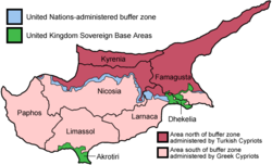
Natural geographic features of Cyprus

Regions of Cyprus

Administrative divisions of Cyprus

Administrative divisions of Cyprus

Districts of Cyprus

Districts of Cyprus

Municipalities of Cyprus

Demography of Cyprus

Demographics of Cyprus

Government and politics of Cyprus

Politics of Cyprus

Branches of the government of Cyprus

Government of Cyprus

Executive branch of the government of Cyprus

Legislative branch of the government of Cyprus

Judicial branch of the government of Cyprus

Court system of Cyprus

Foreign relations of Cyprus

Foreign relations of Cyprus

International organization membership

The Republic of Cyprus is a member of: [1]

Law and order in Cyprus

Law of Cyprus

Military of Cyprus

Cypriot National Guard

Local government in Cyprus

Local government in Cyprus

History of Cyprus

History of Cyprus

History of Cyprus, by period

History of Cyprus, by region

History of Cyprus, by subject
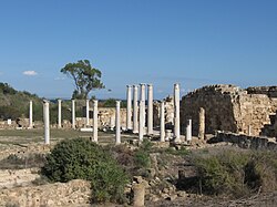
Civilian casualties and displacements during the Cyprus conflict

Culture of Cyprus

Gothic-style church of Panagia (19th century) at the northern part of the island. Today it functions as a mosque Panagia Lysis Cyprus.jpg
Gothic-style church of Panagia (19th century) at the northern part of the island. Today it functions as a mosque
Kyrenia Castle, view from the Old harbour Kyrenia 01-2017 img11 Castle exterior.jpg
Kyrenia Castle, view from the Old harbour
Traditional costumes of Cypriots photographed in 1873 Cyprus 19th cent costumes.png
Traditional costumes of Cypriots photographed in 1873
Cyprus Museum in Nicosia Nicosia 01-2017 img28 Cyprus Museum.jpg
Cyprus Museum in Nicosia

Culture of Cyprus

Art in Cyprus

People of Cyprus

People of Cyprus

Religion in Cyprus

Lala Mustafa Pasha Mosque in Famagusta St. Nikolaos Mustafa- Pascha-Moschee C.jpg
Lala Mustafa Pasha Mosque in Famagusta

Religion in Cyprus

Sports in Cyprus

Sports in Cyprus

Economy and infrastructure of Cyprus

Euro banknotes Euro banknotes 2002.png
Euro banknotes
Larnaca International Airport Larnaka International Airport.JPG
Larnaca International Airport

Economy of Cyprus

Open pit copper mine Skouriotissa in Cyprus Geology of Cyprus-SkiriotissaMine.jpg
Open pit copper mine Skouriotissa in Cyprus

Communications in Cyprus

Communications in Cyprus

Energy in Cyprus

Energy in Cyprus

Transport in Cyprus

Paphos Lighthouse Lighthouse Paphos Cyprus 04.jpg
Paphos Lighthouse

Transport in Cyprus

Education in Cyprus

Education in Cyprus

Health in Cyprus

Health in Cyprus

See also

Cyprus

Related Research Articles

<span class="mw-page-title-main">Cyprus</span> Mediterranean island nation in Europe

Cyprus, officially the Republic of Cyprus, is an island country located south of the Anatolian Peninsula in the eastern Mediterranean Sea. It is geographically in Western Asia, but its cultural ties and geopolitics are overwhelmingly Southeastern European. Cyprus is the third-largest and third-most populous island in the Mediterranean. It is located north of Egypt, east of Greece, south of Turkey, and west of Lebanon and Syria. Its capital and largest city is Nicosia. The northeast portion of the island is de facto governed by the self-declared Turkish Republic of Northern Cyprus.

<span class="mw-page-title-main">Geography of Cyprus</span>

Cyprus is an island country in the Eastern Basin of the Mediterranean Sea. It is the third-largest island in the Mediterranean, after the Italian islands of Sicily and Sardinia, and the 80th-largest island in the world by area. It is located south of the Anatolian Peninsula, yet it belongs to the Cyprus Arc. Geographically, Cyprus is located in West Asia, but the country is considered a European country in political geography. Cyprus also had lengthy periods of mainly Greek and intermittent Anatolian, Levantine, Byzantine, Turkish, and Western European influence.

<span class="mw-page-title-main">Politics of Cyprus</span> Political system of Cyprus

The Republic of Cyprus is a unitary presidential representative republic, whereby the President of Cyprus is both head of state and head of government. Executive power is exercised by the government. Legislative power is vested in both the government and the parliament. The Judiciary is independent of the executive and the legislature.

<span class="mw-page-title-main">Nicosia</span> Capital of Cyprus and Northern Cyprus (de facto)

Nicosia is the capital and largest city of Cyprus. It is located near the centre of the Mesaoria plain, on the banks of the River Pedieos.

<span class="mw-page-title-main">Akrotiri and Dhekelia</span> British Overseas Territory on the island of Cyprus

Akrotiri and Dhekelia, officially the Sovereign Base Areas of Akrotiri and Dhekelia (SBA), is a British Overseas Territory on the island of Cyprus. The areas, which include British military bases and installations formerly part of the Crown colony of Cyprus, were retained by the British under the 1960 treaty of independence signed by the United Kingdom, Greece, Turkey and representatives from the Greek and Turkish Cypriot communities. The territory serves an important role as a station for signals intelligence and provides a vital strategic part of the United Kingdom surveillance-gathering network in the Mediterranean and the Middle East.

ISO 3166-2:CY is the entry for Cyprus in ISO 3166-2, part of the ISO 3166 standard published by the International Organization for Standardization (ISO), which defines codes for the names of the principal subdivisions of all countries coded in ISO 3166-1.

<span class="mw-page-title-main">Telephone numbers in Cyprus</span> Telephone guide to Cyprus closed telephoning numbering plan.

Telephone numbers in Cyprus follow a closed telephone numbering plan which was adopted on 1 December 2001. As a result, for landline phone numbers the digit 2 followed by the old area code was affixed to the subscriber number and for mobile phones 9 was affixed to the phone number. The plan is also used in Akrotiri and Dhekelia.

<span class="mw-page-title-main">Demetris Christofias</span> President of Cyprus from 2008 to 2013

Demetris Christofias was a Cypriot politician, who served President of Cyprus from 2008 to 2013. He was previously President of the House of Representatives from 2001 to 2008 and General Secretary of the Progressive Party of Working People from 1988 to 2009.

The Treaty of Guarantee is a treaty between Cyprus, Greece, Turkey, and the United Kingdom that was promulgated in 1960.

<span class="mw-page-title-main">Cyprus–United Kingdom relations</span> Bilateral relations

Cypriot–British relations are foreign relations between Cyprus and the United Kingdom. Cyprus gained its independence from the United Kingdom in 1960, after 82 years of British control. The two countries now enjoy warm relations; however, the continuing British sovereignty of the Akrotiri and Dhekelia Sovereign Base Areas has continued to divide Cypriots. The two countries share membership of the United Nations and the Commonwealth of Nations.

<span class="mw-page-title-main">Outline of Northern Cyprus</span> Overview of and topical guide to Northern Cyprus

The following outline is provided as an overview of and topical guide to Northern Cyprus:

<span class="mw-page-title-main">Sovereign Base Areas Customs and Immigration</span> Customs agency of the UKs Sovereign Base Areas

Sovereign Base Areas Customs and Immigration is a semi-autonomous branch of HM Revenue and Customs (HMRC) of the United Kingdom. It has jurisdiction over Akrotiri and Dhekelia, a British Overseas Territory on the island of Cyprus, administered as a Sovereign Base Area, and home to British Forces Cyprus. It is managed by the Ministry of Defence (MoD) and around 3,500 military personnel are posted there at any one time.

Prostitution in Cyprus is not illegal, but operating brothels, organising prostitution rings, living off the profits of prostitution, encouraging prostitution or forcing a person to engage in prostitution are illegal activities.

This page list topics related to Cyprus.

<span class="mw-page-title-main">Paramali</span> Village in Limassol District, Cyprus

Paramali is a village on the south coast of the island of Cyprus, in the Limassol District 4 kilometres (2.5 mi) east of Avdimou. Its district covers an area stretching north from the south coast of Cyprus, with roughly equal parts falling in the British Overseas Territory of Akrotiri and Dhekelia to the south, and in the Republic of Cyprus to the north.

<span class="mw-page-title-main">Postal codes in Cyprus</span>

Four digit post codes were introduced in Cyprus on 1 October 1994. The system is organised around the six administrative districts for local government on the island, with each district allocated a numerical range. Most of the four digit numbers are allocated to small geographic areas, such as streets, urban communes or villages, although some are reserved for government use.

<span class="mw-page-title-main">Evangelos Florakis Naval Base explosion</span> 2011 self-detonation of a munitions stockpile in Mari, Cyprus

On 11 July 2011, at Evangelos Florakis Naval Base, situated at Mari, Larnaca in Cyprus, a large amount of ammunition and military explosives self-detonated, killing 13 people, including the Commander of the Cyprus Navy, Andreas Ioannides, the base commander, Lambros Lambrou, and six firefighters. A further 62 people were injured. The explosion was the worst peacetime military accident ever recorded in Cyprus, with a yield of approximately 481 tons TNT equivalent, as determined by the official investigation into the accident. It was the largest artificial non-nuclear explosion of the 21st century until the 2020 Beirut explosions.

<span class="mw-page-title-main">Borders of Akrotiri and Dhekelia</span>

The borders of Akrotiri and Dhekelia refer to the international boundary between the Sovereign Base Areas of Akrotiri and Dhekelia and the republic of Cyprus.

Events in the year 2011 in Cyprus.

References

  1. "Cyprus". The World Factbook . United States Central Intelligence Agency. July 2, 2009. Retrieved July 23, 2009.

Gnome-globe.svg Wikimedia Atlas of Cyprus

Air Ambulance Cyprus

Government
General information
Official publications
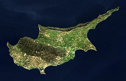