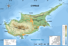
Cyprus is an island in the Eastern Basin of the Mediterranean Sea. It is the third-largest island in the Mediterranean, after the Italian islands of Sicily and Sardinia, and the 80th-largest island in the world by area. It is located south of the Anatolian Peninsula, yet it belongs to the Cyprus Arc. Geographically, Cyprus is located in West Asia, but the country is considered a European country in political geography. Cyprus also had lengthy periods of mainly Greek and intermittent Anatolian, Levantine, Byzantine, Turkish, and Western European influence.

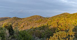
Troodos is the largest mountain range in Cyprus, located in roughly the center of the island. Its highest peak is Mount Olympus, also known as Chionistra, at 1,952 metres (6,404 ft), which hosts the Sun Valley and North Face ski areas with their five ski lifts.

The Kyrenia Mountains is a long, narrow mountain range that runs for approximately 160 km (100 mi) along the northern coast of the island of Cyprus. It is primarily made of hard crystalline limestone, with some marble. Its highest peak is Mount Selvili, at 1,024 m (3,360 ft). Pentadaktylos is another name for the Kyrenia Mountains, though Britannica refers to Pentadaktylos as the "western portion" of the latter, or the part west of Melounta. Pentadaktylos is so-named after one of its most distinguishing features, a peak that resembles five fingers.
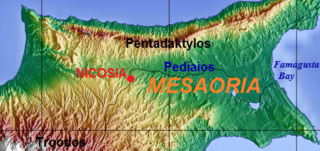
The Mesaoria is a broad, sweeping plain which makes up the north centre of the island of Cyprus.

Akamas, is a promontory and cape at the northwest extremity of Cyprus with an area of 230 square kilometres. Ptolemy described it as a thickly wooded headland, divided into two by summits [a mountain range] rising towards the north. The peninsula is named after Akamas, a son of Theseus, hero of the Trojan War and founder of the city-kingdom of Soli.
The Habitats Directive is a directive adopted by the European Community in 1992 as a response to the Berne Convention. The European Community was reformed as the European Union the following year, but the directive is still recognised.

The Karpas Peninsula, also known as the Karpass, Karpaz or Karpasia, is a long, finger-like peninsula that is one of the most prominent geographical features of the island of Cyprus. Its farthest extent is Cape Apostolos Andreas, and its major population centre is the town of Rizokarpaso. It is currently under the de facto control of the internationally-unrecognised state of Northern Cyprus.
The Cypriot mouse is a species of mouse endemic to Cyprus. Its primary habitat seems to be the vineyards and fields of the Troödos Mountains region.

The wildlife of Libya is spread over the Mediterranean coastline and encompasses large areas of the Saharan desert. The protection of wildlife is provided through appropriate legislation in seven national parks, five reserves, 24 protected areas, two wetlands under Ramsar Convention, and also in other areas. Apart from these, there are also five UNESCO World Heritage Sites related to culture. The most important national parks are the El-Kouf National Park and Karabolli National Park. The well known nature reserves are the Benghazi Reserve and the Zellaf Reserve. The wildlife species recorded in the country are 87 mammals and 338 species of birds.

Platres or Pano Platres, is a Μountainous village in Cyprus. It is located on the southern slopes of the Troodos Mountains and is one of the wine villages. Platres is the largest Troodos resort, situated about 5km from Troodos Square, 25 kilometers (16 mi) north-west of Limassol and 45 kilometers (28 mi) south-west of the capital Nicosia. Platres is a very old village and is mentioned among the 119 villages of the Limassol district that existed during the Lusignan Era and the Venetian Era. Platres is the principal hill resort of Cyprus. The town has a resident population of fewer than 300, but this can swell to 10,000 during tourist seasons.

The wildlife of Cyprus includes its flora and fauna and their natural habitats. Cyprus has a rich flora and a diverse fauna albeit with relatively few mammals. Like most modern countries, the natural habitats in Cyprus have been steadily disappearing, currently retaining only 20% of its original habitat due to rapid urbanization, usage of forests for commercial purposes, tourism and various other reasons. One of the features of Cyprus' habitats is the wild and sharp differences in elevations and habitats on the island as well as climate, all of which supply a diverse habitat for an array of fauna and flora. Terra Cypria was established as a trust in 1992 to conserve the Cypriot environment and its biodiversity.

The National Marine Park of Zakynthos founded in 1999, is a national park located in Laganas bay, in Zakynthos island, Greece. The park, part of the Natura 2000 ecological network, covers an area of 135 square kilometres (52 sq mi) and is the habitat of the loggerhead sea turtle. It is the first national park established for the protection of sea turtles in the Mediterranean.
Nepeta italica subsp. troodi, synonym Nepeta troodi, commonly known as Troodos cat-mint is a suberect, aromatic, perennial herb, 20–50 cm high, with a woody base and hairy tetragonal shoots. The leaves are opposite, simple, serrate, cordate at the base, deltoid, with an obtuse apex, 1-4 x 0.6–2 cm, petiolate, densely hairy. The flowers are arranged in many flowered verticillasters, and are zygomorphic, with a white corolla white and a dotted purple lower lip. It flowers June to October. The fruit is composed of 4 nutlets.

Sedum cyprium, the Cyprus stonecrop, is an erect, monocarpic, succulent herb with an unbranched stem, 10–30 cm high. Leaves succulent, simple and entire reddish in sunny positions, the basal leaves in rosettes, hairless, spathulate, 3-6 x 1–2 cm, the higher leaves are thinly glandular and spirally arranged. Its numerous actinomorphic flowers are greenish or reddish, gathered in a cylindrical panicle. Sedum cyprium flowers from June to September. Its fruit has a many-seeded follicle.
Gagea juliae, the yellow star-of-Cyprus, is a plant species in the lily family, native to Cyprus and southern Turkey.

For a small country, Albania is characterised by a considerable wealth of terrestrial and marine ecosystems and habitats with contrasting floral, faunal, and fungal species, defined in an area of 28,748 square kilometres. Most of the country is predominantly of Mediterranean character, comprehending the country's center and south, while the alpine affinity is more visible in the northeast.
Pullu I Nature Park is a coastal nature park in Anamur ilçe (district) of Mersin Province, Turkey. The index "I" is to distinguish the park from a neighboring park with the same name.
The Albanian Ionian Sea Coast is a coastline of the north-eastern Ionian Sea, that encompasses the south-western border of the Republic of Albania, stretching from the southern half of Karaburun Peninsula, across the historical region of Labëria, the city of Sarandë, the mountains of the Ceraunians, and the Albanian Riviera, to the Lake of Butrint, where the Strait of Corfu separates the country from Greece.