Climate of Kosovo

Last updated
Precipitation kosovo.jpg

Kosovo is a relatively small country. Because of the climatic position and complicated structure of the relief it has a variety of climate systems.

Contents

Kosovo lies in the south part of the middle geographical latitude of the northern hemisphere and it is affected by the Mediterranean Mild Climate and European Continental Climate. Important factors that affect Kosovo's climate are: its position towards Eurasia and Africa, hydrographic masses (Atlantic Ocean and Mediterranean sea), atmospheric masses (tropic, arctic and continental) and others. Minor factors are: relief, hydrography, plain and vegetation. [1]

Areas

The view of Opoja region on the bottom, lower section of Koritnik, and Pashtrik mountain in the center. All in one.jpg
The view of Opoja region on the bottom, lower section of Koritnik, and Pashtrik mountain in the center.

The climatic area of the Ibar valley is influenced by continental air masses. For this reason, in this part of the region, the winters are colder with medium temperatures above −10 °C (14 °F), but sometimes down to −26 °C (−15 °F). The summers are very hot with average temperatures of 20 °C (68 °F), sometimes up to 37 °C (99 °F). This area is characterized by a dry climate and a total annual precipitation of 600 mm per year, approximately. The climatic area of dukagjini, which includes the watershed of the White Drin river, is influenced very much by the hot air masses, which cross the Adriatic Sea. Medium temperatures during winter range from 0.5 °C (32.9 °F) to sometimes 22.8 °C (73.0 °F). The average annual precipitation of this climatic area is about 700 mm (28 in) per year. The winter is characterized by heavy snowfalls. The climatic area of the mountains and forest parts is characterised by a typical forest clime, that is associated with heavy rainfalls (900 to 1,300 mm (35 to 51 in) per year), and summers that are very short and cold, and winters that are cold and with a lot of snow. Finally, it can be stated that the Kosovo territory is characterised by a sunny climate with variable temperature and humidity conditions. [2] General air flows, physical, geographical and topographical characteristics enforce territorial and temporal changes of climatic elements.

Air Temperature

Air Temperature is the main climatic element which tells the degree of air heat near-earth layers. In Kosovo there are thermal differences in horizontal and vertical direction. The eastern side is colder than the western part.

The average temperature of Kosovo for a year is 9.5 °C (49.1 °F). The warmest month is July with 28.3 °C (82.9 °F), the coldest is January with −18.7 °C (−1.7 °F). The highest average temperature for a year is in Prizren (12 °C (54 °F)), the lowest temperature in Podujevo (9 °C (48 °F)). Except Prizren and Istok, all other meteorological stations, in January have average temperatures under 0 °C (32 °F).

Except average temperature values, thermal characteristics of Kosovo will be better understood in the analyze of extreme values. Maximal values in all meteorological stations are higher than 35 °C (95 °F), while the absolute lowest value was registered on June 6, 1963 in Gjilan with a value of −32.5 °C (−26.5 °F). Based on the summary, the amplitude of the average of the average values in Kosovo is 20.5 °C (68.9 °F). Movements of air temperature from year to year are pretty much noticeable. In lower parts of Kosovo, tropic days usually last for 30 days. [3]

CityElevationJanFebMarAprMayJunJulAugSepOctNovDecYear
Peja5230.11.35.911.515.419.522.220.917.712.67.90.811.3
Prizren4361.43.17.812.916.821.123.722.819.3149.32.512.9
Mitrovica521-0.70.55.310.514.918.921.520.316.811.97.20.510.6
Prishtina630-0.90.14.810.514.919.121.12016.311.87.10.310.4
Air temperatures in Kosovo measured in Celsius (°C) [4]

Precipitation

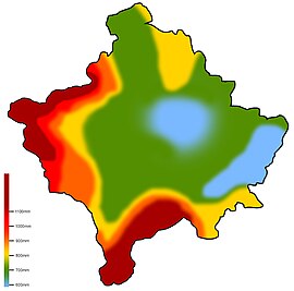
Precipitation is an important indicator of the climate in Kosovo and it represents a meteorological element with significant changes with time and territory. Key features of the rainfall of each territory are: the submission forms, their distribution during the year, annual amount, pluviometric regime, the number of days with precipitation and their intensity. You can see all precipitation forms in Kosovo. Important significance has the rainfall in hills and valleys, and heavy snowfall in the high mountain areas such as Accursed Mountains and Šar Mountains. The presence of hail is an unfortunate phenomenon for the agriculture in Kosovo. This form of precipitation mostly occurs during July and August.

Even though Kosovo lies in a relatively small territory, there are noticeable differences between territories and their amount of precipitation. Kosovo is affected by middle-maritime and middle-continental precipitation regime. On the west, the middle-maritime form is more present. This type of precipitation regime is known for big rainfalls during the year (over 700 mm (28 in)), the maximum amount during November and the minimum during summer. The eastern part is affected by the middle-continental type of precipitation, which is known with lack of rainfall during a year (over 600 mm (24 in)), the maximum amount during May and the minimum during winter. The biggest amount of rainfall is in the west part of Accursed Mountains with over 1,750 mm (69 in), while the lowest amount of rainfall can be found in the east part – Kosovska Kamenica with less than 600 mm (24 in). Snowfall is a common occurrence during the cold months of the year. In the low parts of Kosovo there are averagely 26 days with snowfall, while the high parts have over 100 days. The number of days with snow and the thickness depend on the relief. Snowfall has an importance on keeping the wetness of the surface, creating water reserves, tourism etc. [5]

Winds

Winds are a random meteorological phenomenon in Kosovo. The dominant wind direction usually has the bigger force and speed. The average wind speed in Kosovo is 1.3 m/s in Peja to 2.4 m/s Ferizaj. Extreme wind speeds in Kosovo are around 31 m/s which occur during March and April; usually end up with causing damage on houses. [6]

Insolation

Graphical chart on Kosovo's insolation Kosovo insolation.png
Graphical chart on Kosovo's insolation

Insolation is a measure of solar radiation energy received on a given surface area and recorded during a given time. [8] Insolation is a climatic element that has an importance in different economical activities such as: agriculture, tourism etc.

The period of insolation depends on astronomical, meteorological and relief factors. Insolation is smaller in narrow valleys, river valleys and mountain ranges as a result of the increase of overcast and elevation.

Kosovo has on average 2,066 hours with sun per year or approximately 5.7 hours per day. The highest insolation value is in Pristina with 2.140 hours for 1 year, while Peja with the smallest insolation value of 1.958 hours, with 2.067 hours and Prizren with 2.099 hours. The maximum insolation in Kosovo occurs during July, while the lowest insolation occurs in December. [9]

Climatic territorial differences

The climatic changes based on territories depend on various factors, such as: vegetation, humidity of the territory etc. Climate classifications are usually based on: wind exposure, mountain height and direction, climatic effects on vegetation and watercourses. From all the climatic classifications made in Kosovo, the most accurate one is the one provided by W. Köppen. According to this classification, Kosovo is part of C and D types of climate. Kosovo's hot average climate during summer months is under 22 °C (72 °F) and the cold average is above −3 °C (27 °F). According to the thermal characteristics, amount of rainfall and their regime in low parts of Kosovo, we get two subtypes of climate:

The climatic subtype of the western part has soft winters and a big amount of rainfall. These characteristics are inherited by the Mediterranean mild climate. The climatic subtype of Kosovo has cold winters and lack of rainfall, characteristics inherited from the continental type of climate. Even though Kosovo has these climatic characteristics most of the time, there might be a major change in climate on certain years only. In 1992, Kosovo had a very hot and dry summer, which fits the B climatic type of Köppen. D-climatic type which is known for average temperatures of −3 °C (27 °F) during cold months and 15 °C (59 °F) during hot months can be found in high parts of Kosovo, such as Accursed Mountains, the Šar Mountains and Kopaonik. This type of climate is known by the name subalpine and alpine. [10]

Human Effect

Climate is important in human life, as well as vital activist such as: agriculture, rest, recreation, tourism, transport, medicine, sanitary-hygienic conditions. [11]

Weatherboxes

Climate data for Pristina (1991-2020)
MonthJanFebMarAprMayJunJulAugSepOctNovDecYear
Mean daily maximum °C (°F)3.3
(37.9)
5.4
(41.7)
10.1
(50.2)
15.3
(59.5)
19.8
(67.6)
24.1
(75.4)
26.8
(80.2)
27.4
(81.3)
21.6
(70.9)
16.2
(61.2)
10.3
(50.5)
4.4
(39.9)
15.4
(59.7)
Daily mean °C (°F)−0.6
(30.9)
1.1
(34.0)
5.1
(41.2)
10.1
(50.2)
14.8
(58.6)
18.9
(66.0)
21.5
(70.7)
21.8
(71.2)
16.5
(61.7)
11.2
(52.2)
5.9
(42.6)
0.8
(33.4)
10.6
(51.1)
Mean daily minimum °C (°F)−3.7
(25.3)
−2.5
(27.5)
0.6
(33.1)
4.9
(40.8)
9.7
(49.5)
13.8
(56.8)
16.1
(61.0)
16.3
(61.3)
11.8
(53.2)
7
(45)
2.5
(36.5)
−2
(28)
6.2
(43.2)
Average precipitation mm (inches)47
(1.9)
45
(1.8)
62
(2.4)
73
(2.9)
80
(3.1)
67
(2.6)
54
(2.1)
40
(1.6)
49
(1.9)
48
(1.9)
50
(2.0)
60
(2.4)
675
(26.6)
Average precipitation days768910976667889
Mean daily sunshine hours 4.75.37.19.110.111.211.511.08.66.75.74.58.0
Source: [12]
Climate data for Pristina (1961–1990)
MonthJanFebMarAprMayJunJulAugSepOctNovDecYear
Record high °C (°F)15.8
(60.4)
20.2
(68.4)
26.0
(78.8)
29.0
(84.2)
32.3
(90.1)
36.3
(97.3)
39.2
(102.6)
36.8
(98.2)
34.4
(93.9)
29.3
(84.7)
22.0
(71.6)
15.6
(60.1)
39.2
(102.6)
Mean daily maximum °C (°F)2.4
(36.3)
5.5
(41.9)
10.5
(50.9)
15.7
(60.3)
20.7
(69.3)
23.9
(75.0)
26.4
(79.5)
26.7
(80.1)
23.1
(73.6)
17.1
(62.8)
10.1
(50.2)
4.1
(39.4)
15.5
(59.9)
Daily mean °C (°F)−1.3
(29.7)
1.1
(34.0)
5.0
(41.0)
9.9
(49.8)
14.7
(58.5)
17.8
(64.0)
19.7
(67.5)
19.5
(67.1)
15.9
(60.6)
10.6
(51.1)
5.1
(41.2)
0.4
(32.7)
9.8
(49.6)
Mean daily minimum °C (°F)−4.9
(23.2)
−2.8
(27.0)
0.2
(32.4)
4.2
(39.6)
8.5
(47.3)
11.4
(52.5)
12.5
(54.5)
12.3
(54.1)
9.4
(48.9)
5.0
(41.0)
0.9
(33.6)
−3.1
(26.4)
4.4
(39.9)
Record low °C (°F)−27.2
(−17.0)
−24.5
(−12.1)
−14.2
(6.4)
−5.3
(22.5)
−1.8
(28.8)
0.5
(32.9)
3.9
(39.0)
4.4
(39.9)
−4.0
(24.8)
−8.0
(17.6)
−17.6
(0.3)
−20.6
(−5.1)
−27.2
(−17.0)
Average precipitation mm (inches)38.9
(1.53)
36.1
(1.42)
38.8
(1.53)
48.8
(1.92)
68.2
(2.69)
60.3
(2.37)
51.6
(2.03)
44.0
(1.73)
42.1
(1.66)
45.4
(1.79)
68.2
(2.69)
55.5
(2.19)
597.9
(23.54)
Average precipitation days (≥ 0.1 mm)13.612.311.412.112.811.98.37.97.58.612.314.5133.2
Average snowy days10.28.36.21.50.00.00.00.00.00.53.48.138.2
Average relative humidity (%)83777065676763626874808371
Mean monthly sunshine hours 70.896.0143.0184.0227.9246.3299.3289.6225.8173.596.970.22,123.3
Source: Republic Hydrometeorological Service of Serbia [13]
Climate data for Prizren (1961–1990)
MonthJanFebMarAprMayJunJulAugSepOctNovDecYear
Record high °C (°F)20.2
(68.4)
22.4
(72.3)
26.0
(78.8)
31.3
(88.3)
33.8
(92.8)
40.6
(105.1)
40.8
(105.4)
37.3
(99.1)
35.8
(96.4)
31.4
(88.5)
25.6
(78.1)
23.7
(74.7)
40.8
(105.4)
Mean daily maximum °C (°F)3.3
(37.9)
6.8
(44.2)
11.9
(53.4)
17.2
(63.0)
22.5
(72.5)
26.0
(78.8)
28.5
(83.3)
28.3
(82.9)
24.5
(76.1)
18.0
(64.4)
11.1
(52.0)
5.0
(41.0)
16.9
(62.4)
Daily mean °C (°F)0.0
(32.0)
2.8
(37.0)
7.1
(44.8)
11.9
(53.4)
16.8
(62.2)
20.2
(68.4)
22.2
(72.0)
21.8
(71.2)
18.1
(64.6)
12.3
(54.1)
6.9
(44.4)
1.8
(35.2)
11.8
(53.2)
Mean daily minimum °C (°F)−3.0
(26.6)
−0.6
(30.9)
2.7
(36.9)
6.9
(44.4)
11.3
(52.3)
14.4
(57.9)
15.8
(60.4)
15.4
(59.7)
12.1
(53.8)
7.3
(45.1)
3.2
(37.8)
−1.0
(30.2)
7.1
(44.8)
Record low °C (°F)−23.6
(−10.5)
−19.1
(−2.4)
−11.7
(10.9)
−2.6
(27.3)
−0.4
(31.3)
3.8
(38.8)
7.3
(45.1)
7.0
(44.6)
−0.8
(30.6)
−4.3
(24.3)
−12.6
(9.3)
−17.4
(0.7)
−23.6
(−10.5)
Average precipitation mm (inches)76.2
(3.00)
54.1
(2.13)
63.5
(2.50)
61.1
(2.41)
66.7
(2.63)
69.7
(2.74)
58.6
(2.31)
127.4
(5.02)
58.2
(2.29)
55.1
(2.17)
88.3
(3.48)
81.1
(3.19)
860.0
(33.86)
Average precipitation days (≥ 0.1 mm)12.812.112.112.812.311.68.97.58.19.312.613.5133.6
Average snowy days7.65.63.80.40.00.00.00.00.00.12.15.825.4
Average relative humidity (%)81756864646158596774798269
Mean monthly sunshine hours 100.292.0139.4176.2224.5290.7300.8285.7220.7163.489.754.12,137.4
Source: Republic Hydrometeorological Service of Serbia [14]
Climate data for Peja (1961–1990)
MonthJanFebMarAprMayJunJulAugSepOctNovDecYear
Record high °C (°F)15.4
(59.7)
22.6
(72.7)
25.0
(77.0)
28.0
(82.4)
31.5
(88.7)
35.8
(96.4)
38.2
(100.8)
35.9
(96.6)
34.1
(93.4)
28.3
(82.9)
22.9
(73.2)
18.9
(66.0)
38.2
(100.8)
Mean daily maximum °C (°F)2.8
(37.0)
6.0
(42.8)
10.9
(51.6)
16.1
(61.0)
20.9
(69.6)
24.1
(75.4)
26.5
(79.7)
26.4
(79.5)
22.7
(72.9)
16.9
(62.4)
10.1
(50.2)
4.5
(40.1)
15.7
(60.3)
Daily mean °C (°F)−0.5
(31.1)
2.1
(35.8)
6.4
(43.5)
11.2
(52.2)
15.9
(60.6)
19.0
(66.2)
21.1
(70.0)
20.8
(69.4)
17.2
(63.0)
11.8
(53.2)
5.9
(42.6)
1.2
(34.2)
11.1
(52.0)
Mean daily minimum °C (°F)−3.6
(25.5)
−1.5
(29.3)
2.0
(35.6)
6.1
(43.0)
10.3
(50.5)
13.3
(55.9)
15.0
(59.0)
14.8
(58.6)
11.5
(52.7)
6.8
(44.2)
2.3
(36.1)
−1.8
(28.8)
6.3
(43.3)
Record low °C (°F)−24.8
(−12.6)
−19.3
(−2.7)
−13.6
(7.5)
−3.8
(25.2)
0.6
(33.1)
3.5
(38.3)
6.7
(44.1)
5.2
(41.4)
−1.2
(29.8)
−4.8
(23.4)
−15.3
(4.5)
−15.2
(4.6)
−24.8
(−12.6)
Average precipitation mm (inches)85.9
(3.38)
71.5
(2.81)
65.2
(2.57)
67.2
(2.65)
68.2
(2.69)
53.0
(2.09)
54.7
(2.15)
48.0
(1.89)
52.1
(2.05)
75.3
(2.96)
118.2
(4.65)
91.4
(3.60)
850.7
(33.49)
Average precipitation days (≥ 0.1 mm)12.012.311.311.513.013.29.98.78.19.512.313.3135.1
Average snowy days8.16.03.70.60.00.00.00.00.00.12.06.527.0
Average relative humidity (%)81756863646460606773818370
Mean monthly sunshine hours 69.593.3143.0172.0207.8257.7274.3264.9206.3152.686.855.31,983.5
Source: Republic Hydrometeorological Service of Serbia [15]

See also

Related Research Articles

<span class="mw-page-title-main">Precipitation</span> Product of the condensation of atmospheric water vapor that falls under gravity

In meteorology, precipitation is any product of the condensation of atmospheric water vapor that falls from clouds due to gravitational pull. The main forms of precipitation include drizzle, rain, sleet, snow, ice pellets, graupel and hail. Precipitation occurs when a portion of the atmosphere becomes saturated with water vapor, so that the water condenses and "precipitates" or falls. Thus, fog and mist are not precipitation but colloids, because the water vapor does not condense sufficiently to precipitate. Two processes, possibly acting together, can lead to air becoming saturated: cooling the air or adding water vapor to the air. Precipitation forms as smaller droplets coalesce via collision with other rain drops or ice crystals within a cloud. Short, intense periods of rain in scattered locations are called showers.

<span class="mw-page-title-main">Mediterranean climate</span> Type of climate

A Mediterranean climate, also called a dry summer climate, described by Köppen as Cs, is a temperate climate type that occurs in the lower mid-latitudes. Such climates typically have dry summers and wet winters, with summer conditions ranging from warm to hot and winter conditions typically being mild to cool. These weather conditions are typically experienced in the majority of Mediterranean-climate regions and countries, but remain highly dependent on proximity to the ocean, altitude and geographical location.

<span class="mw-page-title-main">Climate of India</span> Overview of climatic conditions in India

The climate of India consists of a wide range of weather conditions across a vast geographic scale and varied topography. Based on the Köppen system, India hosts six major climatic sub types, ranging from arid deserts in the west, alpine tundra and glaciers in the north, and humid tropical regions supporting rain forests in the southwest and the island territories. Many regions have starkly different microclimates, making it one of the most climatically diverse countries in the world. The country's meteorological department follows the international standard of four seasons with some local adjustments: winter, summer, monsoon or rainy season, and a post-monsoon period.

<span class="mw-page-title-main">Humid continental climate</span> Category in the Köppen climate classification system

A humid continental climate is a climatic region defined by Russo-German climatologist Wladimir Köppen in 1900, typified by four distinct seasons and large seasonal temperature differences, with warm to hot summers, and cold and snowy winters. Precipitation is usually distributed throughout the year, but often these regions do have dry seasons. The definition of this climate in terms of temperature is as follows: the mean temperature of the coldest month must be below 0 °C (32.0 °F) or −3 °C (26.6 °F) depending on the isotherm, and there must be at least four months whose mean temperatures are at or above 10 °C (50 °F). In addition, the location in question must not be semi-arid or arid. The cooler Dfb, Dwb, and Dsb subtypes are also known as hemiboreal climates.

<span class="mw-page-title-main">Climate of Chicago</span> Hot-summer humid continental climate

The climate of Chicago is classified as hot-summer humid continental with hot humid summers and cold, occasionally snowy winters. All four seasons are distinctly represented: Winters are cold and often see snow with below 0 Celsius temperatures and windchills, while summers are warm and humid with temperatures being hotter inland, spring and fall bring bouts of both cool and warm weather and fairly sunny skies. Annual precipitation in Chicago is moderate and relatively evenly distributed, the driest months being January and February and the wettest July and August. Chicago's weather is influenced during all four seasons by the nearby presence of Lake Michigan.

Milwaukee has a humid continental climate, with four distinct seasons and wide variations in temperature and precipitation in short periods of time. The city's climate is also strongly influenced by nearby Lake Michigan, which creates two varying climates within the Milwaukee area. The Urban heat island effect also plays a role in the city's climate, insulating it from winter cold, but keeping it cooler in spring and summer.

<span class="mw-page-title-main">Climate of Greece</span> Overview of the impacts of the climate change in Greece

The climate in Greece is predominantly Mediterranean. However, due to the country's geography, Greece has a wide range of micro-climates and local variations. The Greek mainland is extremely mountainous, making Greece one of the most mountainous countries in Europe. To the west of the Pindus mountain range, the climate is generally wetter and has some maritime features. The east of the Pindus mountain range is generally drier and windier in summer. The highest peak is Mount Olympus, 2,918 metres (9,573 ft). The northern areas of Greece have a transitional climate between the continental, the Mediterranean and the humid subtropical climate. There are mountainous areas that have an alpine climate. Also, various areas of Greece have semi-arid climates.

<span class="mw-page-title-main">Climate of California</span> Overview of the climate of the U.S. state of California

The climate of California varies widely from hot desert to alpine tundra, depending on latitude, elevation, and proximity to the Pacific Coast. California's coastal regions, the Sierra Nevada foothills, and much of the Central Valley have a Mediterranean climate, with warmer, drier weather in summer and cooler, wetter weather in winter. The influence of the ocean generally moderates temperature extremes, creating warmer winters and substantially cooler summers in coastal areas.

<span class="mw-page-title-main">United States rainfall climatology</span> Characteristics of weather in U.S.

The characteristics of United States rainfall climatology differ significantly across the United States and those under United States sovereignty. Summer and early fall bring brief, but frequent thundershowers and tropical cyclones which create a wet summer and drier winter in the eastern Gulf and lower East Coast. During the winter, and spring, Pacific storm systems bring Hawaii and the western United States most of their precipitation. Low pressure systems moving up the East Coast and through the Great Lakes, bring cold season precipitation to from the Midwest to New England, as well as Great Salt Lake. The snow to liquid ratio across the contiguous United States averages 13:1, meaning 13 inches (330 mm) of snow melts down to 1 inch (25 mm) of water.

<span class="mw-page-title-main">Climate of Romania</span>

The climate of Romania is continental, transitioning into humid subtropical on the eastern coast, influenced by polar intrusions, and therefore characterized by harsh winters. The mountain ranges of the Carpathian arc have a cool mountain climate with high humidity throughout the year.

<span class="mw-page-title-main">Climate of the United States</span> Varies due to changes in latitude, and a range of geographic features

The climate of the United States varies due to changes in latitude, and a range of geographic features, including mountains and deserts. Generally, on the mainland, the climate of the U.S. becomes warmer the further south one travels, and drier the further west, until one reaches the West Coast.

<span class="mw-page-title-main">Climate of Illinois</span>

The Climate of Illinois describes the weather conditions, and extremes, noted within the state of Illinois, United States, over time.

<span class="mw-page-title-main">Climate of Chile</span>

The climate of Chile comprises a wide range of weather conditions across a large geographic scale, extending across 38 degrees in latitude, making generalizations difficult. According to the Köppen system, Chile within its borders hosts at least seven major climatic subtypes, ranging from low desert in the north, to alpine tundra and glaciers in the east and southeast, tropical rainforest in Easter Island, Oceanic in the south and Mediterranean climate in central Chile. There are four seasons in most of the country: summer, autumn, winter, and spring.

<span class="mw-page-title-main">Geography of Kosovo</span> Overview of the geography of Kosovo

Kosovo is a small and landlocked country in Southeastern Europe. The country is strategically positioned in the center of the Balkan Peninsula enclosed by Montenegro to the west, Serbia to the north and east, North Macedonia to the southeast, and Albania to the southwest. It has no direct access to the Mediterranean Sea but its rivers flow into three seas, the Adriatic, Aegean and Black Sea.

<span class="mw-page-title-main">Climate of Vietnam</span> Characteristics of the climate of Vietnam

Vietnam has a monsoon-influenced climate typical of that of mainland Southeast Asia. The diverse topography, long latitude, and influences from the South China Sea lead to climatic conditions varying significantly between regions. The northern region experiences a monsoonal and temperate climate (Cfa) with four distinct seasons with winters typically dry and summers ranging from hot to mild. In more southern areas, the climate is tropical monsoon (Aw) with only two seasons. In addition, a temperate climate exists in mountainous areas, which are found in Sa Pa and Da Lat, while a more continental climate exists in Lai Châu Province and Sơn La Province.

The climate of Seoul features a humid continental climate with dry winter, called "Dwa" in the Köppen climate classification, with four highly distinct seasons. In summer the influence of the North Pacific high-pressure system brings hot, humid weather with temperatures soaring as high as 35 °C (95 °F) on occasion. In winter the city is topographically influenced by expanding Siberian High-pressure zones and prevailing west winds, temperatures dropping almost as low as -20 °C (-4 °F) in severe cold waves. The bitterly cold days are commonly known to come in three-day cycles regulated by rising and falling pressure systems. The most pleasant seasons for most people in the city are spring and autumn, when azure skies and comfortable temperatures are typical. Most of Seoul's precipitation falls in the summer monsoon period between June and September, as a part of East Asian monsoon season.

<span class="mw-page-title-main">Climate of Turkey</span> Overview of the climate of Turkey

Turkey's climate is varied and generally temperate, with the regions bordering the Mediterranean and Black Sea heavily affected by the coasts, and the interior being drier and more continental.

<span class="mw-page-title-main">Climate of Spain</span> Overview of the climate of Spain

The climate in Spain varies across continental Spain. Spain is the most climatically diverse country in Europe with 17 different Köppen climates, excluding the Canary Islands, and is within the 10 most climatically diverse countries in the world. The country is dominated by five major climate regions, with the other regions including smaller portions of the country. The Mediterranean environment and location in Europe mean that it will experience greater heatwaves and dry weather due to climate change.

<span class="mw-page-title-main">Climatic regions of Argentina</span> Overview of climatic regions of Argentina

Due to its vast size and range of altitudes, Argentina possesses a wide variety of climatic regions, ranging from the hot subtropical region in the north to the cold subantarctic in the far south. The Pampas region lies between those and featured a mild and humid climate. Many regions have different, often contrasting, microclimates. In general, Argentina has four main climate types: warm, moderate, arid, and cold in which the relief features, and the latitudinal extent of the country, determine the different varieties within the main climate types.

<span class="mw-page-title-main">Climate of Seattle</span> Overview of climatic conditions in Seattle

The climate of Seattle is temperate, classified in the warm-summer (in contrast to hot-summer) subtype of the Mediterranean zone by the most common climate classification although some sources put the city in the oceanic zone. It has cool, wet winters and mild, relatively dry summers, covering characteristics of both. The climate is sometimes characterized as a "modified Mediterranean" climate because it is cooler and wetter than a "true" Mediterranean climate, but shares the characteristic dry summer and the associated reliance upon cooler-season precipitation. The city is part of USDA hardiness zone 9a, with surrounding pockets falling under 8b.

References

  1. Riza Çavolli 1993, p. 22
  2. "Climatic Conditions". Archived from the original on 2014-05-27. Retrieved 2014-05-27.
  3. Riza Çavolli 1993, p. 23
  4. Departamenti i Gjeografisë 2004, p. 131
  5. Riza Çavolli 1993, p. 24
  6. Riza Çavolli 1993, p. 25
  7. Riza Çavolli 1993, p. 23
  8. Insolation
  9. Riza Çavolli 1993, p. 23
  10. Riza Çavolli 1993, p. 27
  11. Riza Çavolli 1993, p. 27
  12. "Climate: Pristina". Climate-Data. Archived from the original on 2 October 2021. Retrieved 2 October 2021.
  13. "Pristina: Monthly and annual means, maximum and minimum values of meteorological elements for the period 1961–1990". Republic Hydrometeorological Service of Serbia. Archived from the original on 28 July 2020. Retrieved 9 September 2020.
  14. "Prizren: Monthly and annual means, maximum and minimum values of meteorological elements for the period 1961 - 1990". Republic Hydrometeorological Service of Serbia. Archived from the original on 20 July 2021. Retrieved 3 October 2021.
  15. "Peć: Monthly and annual means, maximum and minimum values of meteorological elements for the period 1961 - 1990". Republic Hydrometeorological Service of Serbia. Archived from the original on 3 October 2021. Retrieved 3 October 2021.

Bibliography