
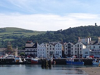
Peel is a seaside town and small fishing port in the Isle of Man, in the historic parish of German but administered separately. Peel is the third largest town in the island after Douglas and Ramsey but the fourth largest settlement, as Onchan has the second largest population but is classified as a village.
Ramsey is a coastal town in the north of the Isle of Man. It is the second largest town on the island after Douglas. Its population is 8,288 according to the 2021 Census. It has one of the biggest harbours on the island, and has a prominent derelict pier, called the Queen's Pier. It was formerly one of the main points of communication with Scotland. Ramsey has also been a route for several invasions by the Vikings and Scots.

The Pyrmont Bridge, a heritage-listed swing bridge across Cockle Bay, is located in Darling Harbour, part of Port Jackson, west of the central business district in the City of Sydney local government area of New South Wales, Australia. Opened in 1902, the bridge initially carried motor vehicle traffic via the Pyrmont Bridge Road between the central business district and Pyrmont. Since 1981 the bridge has carried pedestrian and bicycle traffic only, as motor vehicles were diverted to adjacent freeway overpasses. The bridge was added to the New South Wales State Heritage Register on 28 June 2002, the centenary of its opening.

The Glebe Island Bridge is a heritage-listed disused swing Allan truss road bridge that carried Victoria Road across Johnstons Bay, located in the inner city Sydney suburb of Pyrmont in the City of Sydney local government area of New South Wales, Australia. The bridge, that connected Rozelle to Pyrmont by road, is one of the last remaining swing bridges of its type in Australia and in the world. It was designed by Percy Allan and built from 1899 to 1903 by Bridges Branch of NSW Public Works Department. It is also known as RMS Bridge No. 61. It was added to the New South Wales State Heritage Register on 29 November 2013 and was listed on the Register of the National Estate on 19 April 1989.

River Sulby can refer to one of two rivers on the Isle of Man:
Leonard Ian Singer was a British politician and pharmacist based in Ramsey, Isle of Man.

The Port of Dover is a cross-channel ferry, cruise terminal, maritime cargo and marina facility situated in Dover, Kent, south-east England. It is the nearest English port to France, at just 34 kilometres (21 mi) away, and is one of the world's busiest maritime passenger ports, with 11.7 million passengers, 2.6 million lorries, 2.2 million cars and motorcycles and 80,000 coaches passing through it in 2017, and with an annual turnover of £58.5 million a year. This contrasts with the nearby Channel Tunnel, the only fixed link between the island of Great Britain and the European mainland, which now handles an estimated 20 million passengers and 1.6 million trucks per year.
The Manx Northern Railway (MNR) was the second common carrier railway built in the Isle of Man. It was a steam railway between St John's and Ramsey. It operated as an independent concern only from 1879 to 1905.

The Isle of Man TT Mountain Course or TT Course or Snaefell Mountain Course or Jalmaf Mountain Course is a street and public rural road circuit located in the Isle of Man, used for motorcycle racing. The motorcycle TT Course is used principally for the Isle of Man TT Races and also the separate event of the Isle of Man Festival of Motorcycling for the Manx Grand Prix and Classic TT Races held in September of each year. The start-line for the Isle of Man TT Mountain Course is located on Glencrutchery Road in the town of Douglas, Isle of Man.

SS (RMS) Ellan Vannin was built as an iron paddle steamer in 1860 at Meadowside, Glasgow for the Isle of Man Steam Packet Company. She was originally named Mona's Isle - the second ship in the company's history to be so named. She served for 23 years under that name before being rebuilt, re-engined and renamed in 1883. As Ellan Vannin she served for a further 26 years before being lost in a storm on 3 December 1909 in Liverpool Bay.
The Isle of Man has a rich transport heritage and boasts the largest narrow-gauge railway network in the British Isles with several historic railways and tramways still in operation. These operate largely to what is known as "Manx Standard Gauge" and together they comprise about 65 miles (105 km) of Victorian railways and tramways. The Isle of Man Railway Museum in Port Erin allows people to find out more about the history of the Manx railways, and was until 1998 accompanied by a similar museum in Ramsey, which was dedicated to the history of the electric line, but this was closed and converted into a youth club. The steam railway to the south of the island, electric to the north and mountain line to the summit of Snaefell, the island's only mountain, are all government-owned, and operated under the title Isle of Man Railways, as a division of the island's Department of Infrastructure. The lines at Groudle Glen and Curraghs Wildlife Park are both privately owned but open to the public.

Raad ny Foillan is a coastal long-distance footpath in the Isle of Man. Because it is a closed loop around the coast, it can be walked in either a clockwise or an anti-clockwise direction.
The Channel Ports are seaports in southern England and northern France, which allow for short crossings of the English Channel. There is no formal definition, but there is a general understanding of the term. Some ferry companies divide their routes into "short" and "long" crossings. The broadest definition might be from Plymouth east to Kent and from Roscoff to Zeebrugge although a tighter definition would exclude ports west of Newhaven and Dieppe. A historic group of such ports is the Cinque Ports of south-east England, most of which have ceased to be commercial ports.

Douglas Harbour is located near Douglas Head at the southern end of Douglas, the capital of the Isle of Man. It is the island's main commercial shipping port. The Port of Douglas was the first in the world to be equipped with radar.

The Isle of Man Sea Terminal is the arrival and departure point for all passenger and car ferries operating to and from the Isle of Man, and is located in Douglas, the island's capital. It is one of the two main gateways to the Isle of Man, the other one being the Isle of Man Airport. It is operated by and is the main hub for the Isle of Man Steam Packet Company, which runs year-round sailings to Heysham, and seasonal sailings to Liverpool, Belfast and Dublin in the summer and Birkenhead at weekends in the winter.

Heysham Port is situated by the village of Heysham, Lancashire, England. The harbour ships mainly roll-on/roll-off freight with one passenger service run by the Isle of Man Steam Packet Company, which operates a twice daily sailing to Isle of Man. There are three freight routes run by Seatruck Ferries and Stena Line which all sail to Ireland daily. The passenger terminal has a rail service which links to Lancaster via Morecambe. Also adjacent to the dock site is a Heysham nuclear power station which was built between 1970 and 1988.

SS (RMS) Peveril (I) No. 76307 – the first vessel in the company's history to be so named – was a packet steamer which was operated by the Isle of Man Steam Packet Company until she sank off Douglas following a collision with SS Monarch in 1899.

The Isle of Man Coastguard also known as the Manx Coastguard is the coastguard service of the Isle of Man Government. It is responsible for the provision of coastguard services throughout the Isle of Man, an independent Crown dependency located in the Irish Sea between England and Ireland. Its main responsibilities are coastal patrol, pollution control, and the provision of shore-based search and rescue services.

Scale Lane Footbridge is an apostrophe-shaped pedestrian swing bridge in Hull, England. The bridge has a rotating mechanism, allowing it to swing open horizontally, letting vessels pass beneath on the River Hull. It was the first bridge in the world to allow pedestrians to remain on the bridge while it is in motion.

