
Laxey is a village on the east coast of the Isle of Man. Its name derives from the Old Norse Laxa meaning 'Salmon River'. Its key distinguishing features are its three working vintage railways and the largest working waterwheel in the world. It is also the location of King Orry's Grave.
Kip Water, also known as the River Kip, is a short river in Inverclyde, Scotland which gives the village of Inverkip its name. It originates at Cornalees in the hills between Inverkip and Greenock and runs through Shielhill Glen, Dunrod Glen and the Kip Valley before entering the Firth of Clyde at Kip Marina in Inverkip.

The Bladnoch is a river in Wigtownshire in the Machars of Galloway in southwest Scotland. One of the earliest descriptions of it is given by Sir Andrew Agnew of Lochnaw and Sir David Dunbar in an appendix to Andrew Symson's work "A Large Description of Galloway" written in the 17th century. In this they state that:
Blaidzenoch which floweth from the mountnous parts of Penninghame, and runs from the north to the south. It runneth through Lochmabary, and by the way it receaveth into several waters; the most considerable is the water of Tarfe, which hath its rise from Airtfeeld, in the Muirs of Luce, and falleth into Blaidzenoch, under the house of Craighlaw. The Blaidzenoch turns to the east, and after it heth fra its source run twenty miles (32 km), it falleth into the Bay of Wigtown, near above the place of Baldone.
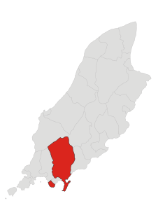
Santon, historically Santan, is one of the seventeen historic parishes of the Isle of Man.
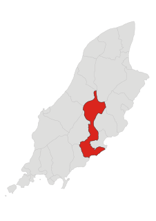
Braddan is one of the seventeen parishes of the Isle of Man.

Middle is one of the six sheadings of the Isle of Man.

Glenfaba is one of the six sheadings of the Isle of Man.

The River Garnock, the smallest of Ayrshire's six principal rivers, has its source on the southerly side of the Hill of Stake in the heart of the Clyde Muirshiel Regional Park. About a mile and a half south of this starting point the untested stream tumbles over the Spout of Garnock, the highest waterfall in Ayrshire, once thought to be the river's origin. The river then continues, for a total length of 20 miles (32 km) or so, through the towns of Kilbirnie, Glengarnock, Dalry and Kilwinning to its confluence with the River Irvine at Irvine Harbour.
The Crogga River is a river in the Isle of Man.
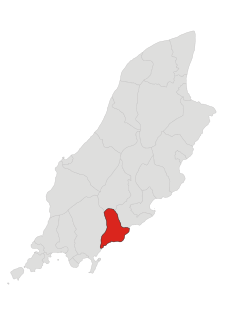
Malew is one of the seventeen parishes of the Isle of Man.

Santon railway station is a request stop near Newtown in the parish of Santon, Isle of Man; it forms part of the sole remaining line of the Isle of Man Railway which once encompassed over 46 miles of network and retains its original station building. The halt sometimes plays host to Santa's Grotto each December as part of the railway's Santa Trains service although between 2010 and 2013 it was not utilised for this purpose. The railway station is situated off the A5 Port Erin to Douglas road, between the railway stations of Ballasalla and Port Soderick.

The River Swilly is a river in County Donegal, Ireland, which flows in an eastern direction through Letterkenny. Letterkenny, the largest town in County Donegal, is built on the river and became the first crossing point on the river in the 17th century.

The River Irvine is a river that flows through southwest Scotland. Its watershed is on the Lanarkshire border of Ayrshire at an altitude of 810 feet (250 m) above sea-level, near Loudoun Hill, Drumclog, and 7 miles SW by W of Strathaven. It flows 29+1⁄2 mi (47.5 km) westward, dividing the old district of Cunninghame from that of Kyle, until it reaches the sea via Irvine Harbour in the form of the Firth of Clyde, and flows into Irvine Bay by the town of Irvine. It has many tributaries, some of which form parish, district and other boundaries.
One of the characteristics of the Isle of Man Railway are the numerous level crossings and farm crossings along the various routes; many smaller crossing places are marked only by gates the criss-cross farm land and provide access to individual private roads which connect the farms to the main roads. Being largely rural in nature the railway has many of these scattered along the existing South Line, and there were, as one might expect, many more on the closed sections of the railway. These can be summarised as follows, along with other points of interest along the line not covered in the Isle of Man Railway stations section:-

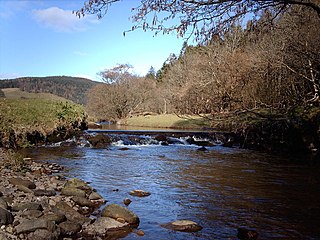
The Silver Burn or Silverburn River is a small river, about five miles (8 km) long, on the Isle of Man which rises near the South Barrule and flows south. It passes St Mark's and in its lower reaches it flows under the Monks' Bridge at Ballasalla, and reaches the sea at Castletown harbour. Just above Ballasalla, the burn runs through wooded Silverdale Glen, a site which the Manx National Trust acquired in 1966.

Ballig is a small hamlet of a few houses situated between the 8th and 9th Milestone road-side markers on the Snaefell Mountain Course between Ballacraine and Glen Helen. It is the site of a former notorious hump-back bridge used for the Isle of Man TT Races on the primary A3 Castletown to Ramsey and the road junction with the A20 Poortown Road in the parish of German in the Isle of Man.

The Bungalow, Isle of Man, one of a handful of better-known vantage points spread around the Snaefell Mountain Course, is situated adjacent to the 31st Milestone roadside marker on the road junction of the primary A18 Mountain Road, the A14 Sulby Glen Road and the road-tramway crossing for the Snaefell Mountain Railway in the parish of Lezayre in the Isle of Man.
Doran's Bend is situated between the 7th and 8th Milestone road-side markers on the Snaefell Mountain Course used for the Isle of Man TT Races on the primary A3 Castletown to Ramsey road in the parish of German in the Isle of Man.

The River Cree is a river in Dumfries and Galloway, Scotland which runs through Newton Stewart and into the Solway Firth. It forms part of the boundary between the counties of Wigtownshire and Kirkcudbrightshire. The tributaries of the Cree are the Minnoch, Trool, Penkiln and Palnure which drain from the Range of the Awful Hand, the labyrinthine range of mountains and lochs, bogs, burns and crags, rising at its highest to The Merrick, Galloway, 12 miles north and visible from Newton Stewart.

Fairy Bridge, Isle of Man is a small bridge over the Santon Burn in the Isle of Man, located on the primary A5 Port Erin to Douglas road, at grid reference 305720, on the parish boundary between Santon and Malew. A superstition associated with the Fairy Bridge is that passers-by must greet the fairies as they cross it; it is considered bad luck not to greet them.

