Related Research Articles
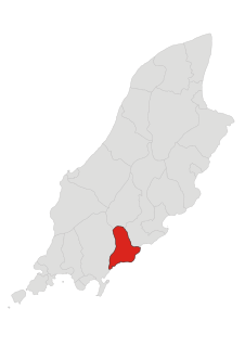
Santon, historically Santan, is one of the seventeen historic parishes of the Isle of Man.
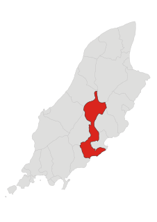
Braddan is one of the seventeen parishes of the Isle of Man.

Middle is one of the six sheadings of the Isle of Man.

Glenfaba is one of the six sheadings of the Isle of Man.

Lezayre, formally Kirk Christ Lezayre, is one of the seventeen historic parishes of the Isle of Man.
Mount Murray is a hill 222 metres (728 ft) above sea level on the Isle of Man located at the northern end of Santon, near the boundaries with Marown and Braddan parishes. It is named after Lord Henry Murray, 4th Lieutenant Governor of the Isle of Man. Often referred to simply as The Mount and formerly as Cronk Glass(green hill), Mount Murray is home to the Chibbanagh Plantation and nine of the eighteen holes of the Mount Murray Golf Club.

Colby railway station is a small railway station on the southern edge of the village of Colby in the south of the Isle of Man served by the Isle of Man Railway; it forms part of the sole remaining section of the network which once covered over 46 miles island-wide.

The Sulby Reservoir is the largest reservoir or lake in the Isle of Man, with an area of 154 acres (62 ha).

Braddan Bridge is a bridge over the river Dhoo on the Douglas to Peel road, from which a halt on the Isle of Man Railway's first line to Peel took its name.

Kirk Michael Railway Station was an intermediate station on the Manx Northern Railway (MNR), which ran between St. John's and Ramsey in the Isle of Man, later owned and operated by the Isle of Man Railway; it served the village of Kirk Michael.

Greeba Castle is a castle on the Isle of Man.

Governor's Bridge is a hairpin bend adjacent to a road junction on the primary A18 Mountain Road in the parish of Onchan in the Isle of Man, with a sudden drop in elevation leading to Governor's Dip, followed by a left-hand bend and finally a right exiting on to the main Glencrutchery Road.

The Bungalow, Isle of Man, one of a handful of better-known vantage points spread around the Snaefell Mountain Course, is situated adjacent to the 31st Milestone roadside marker on the road junction of the primary A18 Mountain Road, the A14 Sulby Glen Road and the road-tramway crossing for the Snaefell Mountain Railway in the parish of Lezayre in the Isle of Man.

Onchan, historically Kirk Conchan, is one of the seventeen historic parishes of the Isle of Man.

Groudle Glen Station is the first mandatory stopping point and major station on the Manx Electric Railway which serves the village of Groudle Glen in the Isle of Man, and is situated between Groudle Lane and Eskadale on the route to Laxey and Ramsey.

Quarterbridge is situated soon after the 1 mile-marker measured from the TT Grandstand, part of the Snaefell Mountain Course used for the Isle of Man TT races, at the junction of the primary A1 Douglas to Peel road, A2 Douglas to Ramsey road and the A5 Douglas to Port Erin road which forms the boundary between the parishes of Braddan and Onchan in the Isle of Man.

St Adamnan's Church is the former parish church of Lonan in the Isle of Man. The church is situated in an isolated position, surrounded by open farmland on the eastern coast of the island, between Groudle Glen and Baldrine. The eastern part of the church has been restored, but it is otherwise in a ruinous, though well-tended, condition. St Adamnan was the Abbot of Iona between 679 and 704.

Fairy Bridge, Isle of Man is a small bridge over the Santon Burn in the Isle of Man, located on the primary A5 Port Erin to Douglas road, at grid reference 305720, on the parish boundary between Santon and Malew. A superstition associated with the Fairy Bridge is that passers-by must greet the fairies as they cross it; it is considered bad luck not to greet them.
References
- ↑ "Registered Building No. 81" (PDF). 13 May 1985. With four photos.
Coordinates: 54°07′54″N4°33′12″W / 54.1317°N 4.5533°W