
The Caledonian Canal connects the Scottish east coast at Inverness with the west coast at Corpach near Fort William in Scotland. The canal was constructed in the early nineteenth century by Scottish engineer Thomas Telford.
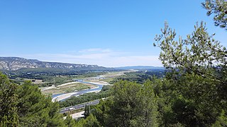
The Durance is a major river in Southeastern France. A left tributary of the Rhône, it is 323.2 km (200.8 mi) long. Its drainage basin is 14,472 km2 (5,588 sq mi).
Balerno is a village on the outskirts of Edinburgh, Scotland situated 8 miles south-west of the city centre, next to Currie and then Juniper Green. Traditionally in the county of Midlothian it now administratively falls within the jurisdiction of the City of Edinburgh Council. The village lies at the confluence of the Water of Leith and the Bavelaw Burn. In the 18th and 19th century, the area was home to several mills using waterpower. In the 20th century, the mills closed and the village now forms a residential suburb of Edinburgh.

Loch Tummel is a long, narrow loch, seven kilometres northwest of Pitlochry in the council area of Perth and Kinross, Scotland. It is fed and drained by the River Tummel, which flows into the River Tay about 13 km (8 mi) south-east of the Clunie Dam at the loch's eastern end.

The River Conon is a river in the Highlands of Scotland. It begins at Loch Luichart, and flows in a south-easterly direction to be joined by the River Meig at Scatwell before passing through Loch Achonachie. It is joined by the Black Water at Moy Bridge, and the River Orrin at Urray, before flowing past Conon Bridge and into the Cromarty Firth.
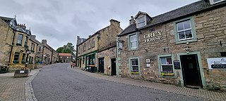
Whitebridge is a small village on the southwest side of Loch Ness in northern Scotland.

The River Garry in Inverness-shire is a Scottish river punctuated by two long Lochs, in the region of Lochaber. It flows broadly west to east through Glen Garry, starting in a wilderness to the east of Knoydart and ending at Loch Oich in the Great Glen, which forms part of the Caledonian Canal. There are a few tiny settlements within Glen Garry, but the only village of any size near to the river is Invergarry, at its mouth. Loch Quoich at the western end of the watercourse is dammed by the largest mass earth fill dam in Scotland, and supplies water to Quoich hydroelectric power station. Loch Garry is dammed by a much smaller dam in the gorge where the river begins its descent to Invergarry, and supplies water to Invergarry hydroelectric power station, close to the mouth of the river. Both hydroelectric schemes were built in the 1950s, with the aim of stimulating economic regeneration in the area. They have altered the ecology of the river, as both lochs were made considerably bigger as a result of constructing the dams.

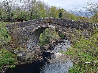
Dairsie Bridge is a 16th-century stone bridge, located 1.2 kilometres (0.75 mi) south of Dairsie, in north-east Fife, Scotland. It carries a minor road across the River Eden, linking the parishes of Dairsie to the north and Kemback to the south. The bridge is protected as a Category A listed building.
Bassendean is a village in the Scottish Borders area of Scotland, 4 kilometres (2.5 mi) south of Westruther and 3 kilometres (1.9 mi) north-west of Gordon. It is by the Eden Water in the former Berwickshire, immediately south of the hamlet of Houndslow.
Gattonside is a small village in the Scottish Borders. It is located 1 kilometre (0.62 mi) north of Melrose, on the north side of the River Tweed. In 1143, the lands of Gattonside were granted to the monks of Melrose Abbey by King David I.
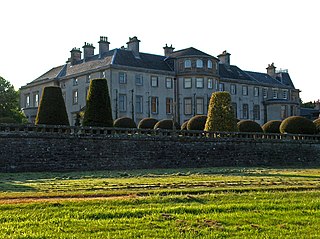
Keir House is a large country house near Stirling in central Scotland. It is located in the parish of Lecropt, 2.5 kilometres (1.6 mi) north-west of Bridge of Allan, in the former county of Perthshire. The estate was home to the Stirling family from the 15th to the 20th century. Keir House is protected as a category A listed building, and the grounds are included on the Inventory of Gardens and Designed Landscapes in Scotland, the national listing of significant gardens.
The River Moriston is a river in Inverness-shire, Scotland. It flows broadly east-north-east from the outfall of the dam at Loch Cluanie to Loch Ness. Its waters and those of its tributaries have been harnessed to generate hydro-electric power.

The Kinnel Bridge is a road bridge near the Scottish town of Templand, in the council area of Dumfries and Galloway. In 1971 the building was included in the Scottish monument lists in category B. The upgrade to the highest monument category A took place in 1988. Furthermore, the bridge together with the Todhillmuir Cottage forms a monument ensemble of category B.

Garrow is a clachan in the Breadalbane region of Perth and Kinross, Scotland. It is located about midway between Kenmore, 4.5 miles to the northwest, and Amulree, 5.3 mi (8.5 km) to the southeast. It sits below the River Quaich, which flows into nearby Loch Freuchie, itself situated between Garrow and Amulree, 2.3 mi (3.7 km) away. Garrow's elevation is about 314 metres.

Tay Street is a major thoroughfare, part of the A989, in the Scottish city of Perth, Perth and Kinross. Planned in 1806 and completed around 1885, it is named for the River Tay, Scotland's longest river, on the western banks of which it sits. The street runs from the confluence of West Bridge Street and Charlotte Street in the north to a roundabout at Marshall Place and Shore Road in the south. Three of the city's four bridges that cross the Tay do so in this stretch : Perth Bridge, Queen's Bridge and the single-track Tay Viaduct, carrying Perth and Dundee trains to and from Perth railway station, located 0.5 miles (0.80 km) to the north-west.
Libberton is a village and historical parish in South Lanarkshire. The village is approximately 2 miles (3.2 km) north of Quothquan and 2.3 miles (3.68 km) south-east of Carnwath. The nearest rivers are the South Medwyn River, the North Medwyn River and the River Clyde which lies the east of the village.
