Queensberry (hill)

Last updated

Queensberry
QueensberryHill.jpg
Highest point
Elevation 697 m (2,287 ft) [1]
Prominence 212 m (696 ft) [1]
Listing Ma,Hu,Tu,Sim, G, D,DN,Y [2]
Coordinates 55°16′55″N3°35′36″W / 55.28192°N 3.59321°W / 55.28192; -3.59321
Geography
Location Southern Uplands, Scotland
Parent range Lowther Hills, Southern Uplands
OS grid NX 98909 99746
Topo map OS Landranger 78

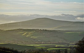
Queensberry is a hill in the Lowther Hills range, part of the Southern Uplands of Scotland. The most southerly mountain in the range, it lies in the parish of Kirkpatrick-Juxta [3] and is a prominent landmark throughout Dumfriesshire. It is frequently climbed from the Daer Reservoir to the north and the minor roads to its south and east. As well as being a placename of multiple addresses throughout southern Scotland, the hill also lend its name to the Duke of Queensberry and Marquess of Queensberry peerages [4] and, subsequently, 'Queensberry Rules' in the sport of boxing.

Related Research Articles

<span class="mw-page-title-main">John Douglas, 9th Marquess of Queensberry</span> British nobleman (1844–1900)

John Sholto Douglas, 9th Marquess of Queensberry, was a British nobleman of the Victorian era, remembered for his atheism, his outspoken views, his brutish manner, for lending his name to the "Queensberry Rules" that form the basis of modern boxing, and for his role in the downfall of the Irish author and playwright Oscar Wilde.

<span class="mw-page-title-main">Dumfries</span> Town in Dumfries and Galloway, Scotland

Dumfries is a market town and former royal burgh in Dumfries and Galloway, Scotland, near the mouth of the River Nith on the Solway Firth, 25 miles (40 km) from the Anglo-Scottish border. Dumfries is the county town of the historic county of Dumfriesshire.

<span class="mw-page-title-main">Dumfries and Galloway</span> Council area of Scotland

Dumfries and Galloway is one of the 32 unitary council areas of Scotland, located in the western part of the Southern Uplands. It is bordered by East Ayrshire, South Ayrshire, and South Lanarkshire to the north; Scottish Borders to the north-east; the English ceremonial county of Cumbria, the Solway Firth, and the Irish Sea to the south, and the North Channel to the west. The administrative centre and largest settlement is the town of Dumfries. The second largest town is Stranraer, located 76 miles (122 km) to the west of Dumfries on the North Channel coast.

<span class="mw-page-title-main">Sanquhar</span> Human settlement in Scotland

Sanquhar is a village on the River Nith in Dumfries and Galloway, Scotland, north of Thornhill and west of Moffat. It is a former Royal Burgh.

<span class="mw-page-title-main">Peeblesshire</span> Historic county in Scotland

Peeblesshire, the County of Peebles or Tweeddale is a historic county of Scotland. Its county town is Peebles, and it borders Midlothian to the north, Selkirkshire to the east, Dumfriesshire to the south, and Lanarkshire to the west.

<span class="mw-page-title-main">Roxburghshire</span> Historic county in Scotland

Roxburghshire or the County of Roxburgh is a historic county and registration county in the Southern Uplands of Scotland. It borders Dumfriesshire to the west, Selkirkshire and Midlothian to the northwest, and Berwickshire to the north. To the southwest it borders Cumberland and to the southeast Northumberland, both in England.

<span class="mw-page-title-main">Dumfriesshire</span> Historic county in Scotland

Dumfriesshire or the County of Dumfries or Shire of Dumfries is a historic county and registration county in southern Scotland. The Dumfries lieutenancy area covers a similar area to the historic county.

<span class="mw-page-title-main">Drumlanrig Castle</span> Castle in Dumfries and Galloway, Scotland, UK

Drumlanrig Castle is situated on the Queensberry Estate in Dumfries and Galloway, Scotland. The category A listed castle is the Dumfriesshire home of the Duke of Buccleuch and Queensberry. As of September 2023, the castle itself is open to the public during very limited times of the year, with the surroundings, such as the stableyard and adventure playground being open nearly all year round. Walking, hiking, and cycling routes are open all year long, unless officially closed due to unforeseen circumstances, such as in 2021 due damage inflicted by Storm Arwen.

<span class="mw-page-title-main">Nithsdale</span> Scottish local government district (1975–1996), part of Dumfries and Galloway region

Nithsdale, also known as Strathnith, Stranith or Stranit, is the strath or dale of the River Nith in southern Scotland. Nithsdale was one of the medieval provinces of Scotland. The provinces gradually lost their administrative importance to the shires created from the twelfth century, with Nithsdale forming part of Dumfriesshire. A Nithsdale district covering a similar area to the medieval province was created in 1975, based in the area's main town of Dumfries. The district was abolished in 1996, since when the area has been directly administered by Dumfries and Galloway Council.

<span class="mw-page-title-main">Sir Robert Grierson, 1st Baronet</span> Scottish nobleman who persecuted Presbyterians in the 17th century

Sir Robert Grierson, 1st Baronet of Lag was a Scottish baronet from Dumfriesshire.

<span class="mw-page-title-main">Archibald Douglas, 8th Marquess of Queensberry</span> British Conservative Party politician

Archibald William Douglas, 8th Marquess of Queensberry PC, styled Viscount Drumlanrig between 1837 and 1856, was a British Conservative Party politician. He notably served as Comptroller of the Household between 1853 and 1856.

<span class="mw-page-title-main">Cummertrees</span> Human settlement in Scotland

Cummertrees is a coastal village and civil parish of Annandale in the historical county of Dumfriesshire in Dumfries and Galloway. It lies about 1 mile (1.6 km) inland, on the Pow Water to the northwest of Powfoot, 12 miles (19 km) from Dumfries and 3 miles (5 km) from Annan.

James Bryden Niven was a Scottish international footballer.

<span class="mw-page-title-main">Beattock railway station</span> Disused railway station in Scotland

Beattock railway station was a station which served the village of Beattock, in the parish of Kirkpatrick-Juxta in the Scottish county of Dumfries and Galloway. It was served by trains on what was originally the Caledonian Main Line, and is now known as the West Coast Main Line. Between 1881 and 1964, Beattock was also the junction for the short branch line to Moffat. Following closure in 1972, the nearest station is at Lockerbie.

<span class="mw-page-title-main">White Coomb</span> Hill in the Moffat Hills of Scotland

White Coomb is a hill in the Moffat Hills range, part of the Southern Uplands of Scotland. Its broad summit is the highest point in the range and the registration county of Dumfriesshire, as well as being the fourth highest point in southern Scotland, however, despite this, it is largely concealed by other hills on all sides except its east and south east, making this the only direction from which its full scale can be seen.

<span class="mw-page-title-main">Kirkpatrick-Fleming</span>

Kirkpatrick-Fleming is a village and civil parish in Dumfries and Galloway, south-west Scotland.

<span class="mw-page-title-main">Kinmount House</span> Historic site in Scotland

Kinmount House is a 19th-century country house in the parish of Cummertrees in the historic county of Dumfriesshire in Dumfries and Galloway region, Scotland. It is located 3+12 miles (5.6 km) west of Annan. The house was designed by Sir Robert Smirke for the 6th Marquess of Queensberry and completed in 1820. It is protected as a category A listed building, and the grounds are included on the Inventory of Gardens and Designed Landscapes in Scotland.

<span class="mw-page-title-main">Kirkpatrick-Juxta</span>

Kirkpatrick-Juxta is a parish in Dumfries and Galloway on the A701, between Biggar, Moffat and Lockerbie. The parish straddles the main road A74 (M). It is primarily a rural parish. One source describes its name as meaning "the lands next to the church of St Patrick". Another source describes it as the church of St. Patrick named in the 15th century as closest to the See of Glasgow. Another source says the original name was Kilpatrick.

William Singer (c.1770–1840) was a Scottish minister who served as Moderator of the General Assembly of the Church of Scotland in 1830. He also was a historian, mapping the Roman roads of Dumfriesshire and also took a strong interest in agricultural improvements.

References

  1. 1 2 "Queensberry". www.hill-bagging.co.uk.
  2. "Database of British and Irish Hills: user guide". www.hills-database.co.uk.
  3. "Genuki: Kirkpatrick-Juxta, Dumfriesshire". www.genuki.org.uk.
  4. Powell C. (2020) Pers. comm., Buccleuch Living Heritage Trust.