Bannockburn

Last updated

Bannockburn
Wfm bannockburn main street.jpg
The centre of Bannockburn
Stirling UK location map.svg
Red pog.svg
Bannockburn
Location within the Stirling council area
Population6,720 (mid-2020 est.) [1]
OS grid reference NS811902
  Edinburgh 35 mi (56 km)  ESE
  London 410 mi (660 km)  SSE
Council area
Lieutenancy area
Country Scotland
Sovereign state United Kingdom
Post town STIRLING
Postcode district FK7
Dialling code 01786
Police Scotland
Fire Scottish
Ambulance Scottish
UK Parliament
Scottish Parliament
Website www.bannockburn.co.uk
List of places
UK
Scotland
56°05′N3°55′W / 56.09°N 3.91°W / 56.09; -3.91

Bannockburn (Scottish Gaelic : Allt a' Bhonnaich) is an area immediately south of the centre of Stirling in Scotland. It is part of the City of Stirling. It is named after the Bannock Burn, a stream running through the town before flowing into the River Forth.

Contents

History

Land in the vicinity of Bannockburn town, probably between the Pelstream and Bannock burns (hence Bannockburn), [2] was the site of the Battle of Bannockburn fought in 1314—one of the pivotal battles of the 13th/14th century Wars of Independence between the kingdoms of Scotland and England. [HES 1] A large monument and visitor centre is located near the site of the battle. [3] In previous generations tourists came to visit the site and look at the Borestone. [4] [HES 2] The dignity of the barony of Bannockburn is currently held by Hope Vere Anderson, a descendant of the Sandilands and Vere families of Sandilands and Lesmahagow, Lanarkshire who were the original Barons of Bannockburn in the 14th century. In the year of 1746, after the Battle of Culloden, Bonnie Prince Charlie stayed in Bannockburn House where he met the future mother of his child.

Telford's circular-arch roadbridge over the Bannock Burn Fm telford bannockburn.jpg
Telford's circular-arch roadbridge over the Bannock Burn

Bannockburn village used to be famous for its carpet and tweed factories [5] and woollen mills. [6] :184–5 In the late 18th and early 19th centuries the Wilson family of Bannockburn designed and wove tartans for the British Army. Many of the so-called Clan tartans were created by the Wilsons in response to the needs of the Clan chiefs who, without their own authentic tartans, approached the Wilsons for suitable patterns. The visit of King George IV to Edinburgh in 1822, and his insistence that the Clan chiefs attend his banquets and levees in their Clan tartans, prompted this reaction. The woollen mills employed 7-800 people around 1880. [7] The last mill closed in 1924. [6] :284–5

The turnpike road between Edinburgh and Stirling was constructed in the 1750s and passed through Bannockburn. The route originally passed over the Old Bridge, until the construction in 1819 of a circular-arch stone bridge, built by engineer Thomas Telford, spanning the burn downstream of the battle site. [6] :178–9 [HES 3] Growth of both Stirling and Bannockburn during the 19th and 20th centuries means that the two now form a contiguous conurbation, and Bannockburn was latterly incorporated into the city (then royal burgh) of Stirling. Bannockburn had a population of 7,352 at the time of the 2001 census. [8]

The area contains most necessary amenities, including a library, and local shops. It is served by Bannockburn Primary School, in the centre of the community, and Bannockburn High School in nearby Broomridge. Several new private housing schemes have been built in and around Bannockburn since the 1990s, increasing pressure on the already overcrowded high school. As a result of this, in 2007 and 2008 Bannockburn High School was extended to provide additional capacity.

Between 1852 and 1949 Bannockburn had a railway station on the Scottish Central Railway, [9] located next to the site of the bus depot. Nowadays, however, residents wishing to use the train must travel into the centre of Stirling. Introduction of a new station with a park-and-ride facility was proposed in the Strategic Transport Projects Review in 2009. [10] Bannockburn is served by the 38, 51 and C30 bus services.

Sports

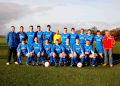
Bannockburn and Hillpark have two amateur football teams, Bannockburn Amateurs [11] (Est. 1968) and Milton FC [12] (Est. 1972). Bannockburn Amateurs won the West of Scotland Amateur Cup for the fifth time in 2019.

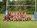
Bannockburn also hosts its own Rugby Club. Formerly known as St Modans HSFP RFC (Est. 1978), it changed its name to Bannockburn RFC in 1996. Bannockburn currently plays in the Scottish Hydro Electric Regional League: Caledonia Division 2 Midlands.

Bannockburn also plays host to St Modans HSFP Cricket Club, who play in the Strathmore and Perthshire Cricket Union Division 1. In July 2013, playing against Perth Doo'cot CC, St Modans scored 329 runs in response to Perth's 326, making it what is believed to be the highest scoring game ever recorded in the SPCU. [13]

Places of worship

The town also has a Gospel Hall and two Church of Scotland churches. Christadelphians meet in a hall on Main Street. [16] The hall used to be a carpet factory. [17]

Notes and references

  1. "Mid-2020 Population Estimates for Settlements and Localities in Scotland". National Records of Scotland. 31 March 2022. Retrieved 31 March 2022.
  2. "OS 25 inch map 1892-1949, with Bing opacity slider". National Library of Scotland. Ordnance Survey. Retrieved 12 October 2017.
  3. Penny Guide to Stirling, Stirling Castle, Wallace Monument, Bannockburn, Etc. R.S. Shearer. 1895. p. 20. Retrieved 5 April 2017.
  4. Ronald, James (1897). The Merchants' guide book to Stirling and district. Stirling: E. MacKay. pp. 52–54.
  5. Illustrated guide to Stirling and the national Wallace monument (9th ed.). Stirling: Mackay, Eneas. 1897. p. 21. Retrieved 7 October 2017.
  6. 1 2 3 Mair, Craig (1990). Stirling: The Royal Burgh. John Donald. ISBN   0859764206.
  7. Francis Groome, ed. (1885). Ordnance Gazetteer of Scotland: A Survey of Scottish Topography, Statistical, Biographical and Historical. Thomas C Jack. Retrieved 19 December 2018.
  8. "2001 CENSUS RESULTS BANNOCKBURN COMMUNITY COUNCIL AREA" (PDF). Corporate Services, Stirling Council. Archived from the original (PDF) on 9 January 2009. Retrieved 3 June 2009.
  9. Brown, David (12 April 2009). "Bannockburn Railway Station". Bannockburn Community Website. Archived from the original on 4 February 2017. Retrieved 3 February 2017.
  10. "Annex A: Summary of Draft Investments". Strategic Transport Projects Review Final Report. Transport Scotland. 2 November 2009. Retrieved 3 February 2017.
  11. Bannockburn Amateurs Archived February 17, 2009, at the Wayback Machine
  12. Milton Amateurs FC Archived April 8, 2009, at the Wayback Machine
  13. Morton, Donald (30 July 2013). "Cricket: Big Ben chimes out in style". Daily Record. Retrieved 28 July 2021.
  14. "Murrayfield United Free Church Of Scotland" . Retrieved 4 November 2017.
  15. "Our Lady and St Ninian's" . Retrieved 4 April 2017.
  16. 'Stirling' on searchforhope.org
  17. J. Smith, 'Bannockburn: The Capital of Tartan Weaving Archived February 6, 2010, at the Wayback Machine ' (2008) on Bannockburn Community Website

Historic Environment Scotland

Related Research Articles

<span class="mw-page-title-main">Battle of Bannockburn</span> 1314 battle during the First War of Scottish Independence

The Battle of Bannockburn was fought on 23–24 June 1314, between the army of Robert the Bruce, King of Scots, and the army of King Edward II of England, during the First War of Scottish Independence. It was a decisive victory for Robert Bruce and formed a major turning point in the war, which ended 14 years later with the de jure restoration of Scottish independence under the Treaty of Edinburgh–Northampton. For this reason, the Battle of Bannockburn is widely considered a landmark moment in Scottish history.

<span class="mw-page-title-main">Stirling</span> Administrative centre and city in Scotland

Stirling is a city in central Scotland, 26 miles (42 km) northeast of Glasgow and 37 miles (60 km) north-west of Edinburgh. The market town, surrounded by rich farmland, grew up connecting the royal citadel, the medieval old town with its merchants and tradesmen, the Old Bridge and the port. Located on the River Forth, Stirling is the administrative centre for the Stirling council area, and is traditionally the county town of Stirlingshire. Proverbially it is the strategically important "Gateway to the Highlands".

<span class="mw-page-title-main">Clan Robertson</span> Scottish clan

Clan Robertson, is correctly known as Clan Donnachaidh is a Scottish clan. The principal surnames of the clan are Robertson, Reid and Duncan but there are also many other septs.

<span class="mw-page-title-main">Selkirk, Scottish Borders</span> Town in Scotland, UK

Selkirk is a town and historic royal burgh in the Scottish Borders council district of southeastern Scotland. It lies on the Ettrick Water, a tributary of the River Tweed.

<span class="mw-page-title-main">Stirling (council area)</span> Council area of Scotland

The Stirling council area is one of the 32 council areas of Scotland, and has a population of about 93,470. It was created in 1975 as a lower-tier district within the Central region. The district covered parts of the historic counties of Stirlingshire and Perthshire, which were abolished for local government purposes. In 1996 the Central region was abolished and Stirling Council took over all local government functions within the area.

<span class="mw-page-title-main">Clan MacLeod</span> Scottish clan

Clan MacLeod is a Highland Scottish clan associated with the Isle of Skye. There are two main branches of the clan: the MacLeods of Harris and Dunvegan, whose chief is MacLeod of MacLeod, who are known in Gaelic as Sìol Tormoid ; the Clan MacLeod of Lewis and Raasay, whose chief is MacLeod of The Lewes, are known in Gaelic as Sìol Torcaill. Both branches claim descent from Leòd, a Norse-Gael who lived in the 13th century.

George Wilson "Doddie" Weir was a Scottish rugby union player who played as a lock. He made 61 international appearances for the Scotland national team and represented the British & Irish Lions.

<span class="mw-page-title-main">Bannock Burn</span> River in Scotland

The Bannock Burn is a stream which rises at about 1,300 feet (400 m) on Touchadam Moor, NS715891, just to the north of Earl's Hill in the Touch Hills to the south-west of Stirling in central Scotland. The Bannock flows eastward and enters the River Forth to the east of Stirling, close to the site of the Battle of Bannockburn (1314), about 7.58 miles (12.20 km) from its source. The burn itself meanders and is considerably longer. A nearby town, nowadays a suburb of Stirling, is accordingly called Bannockburn.

<span class="mw-page-title-main">St. Ninians</span>

St. Ninians is a long-standing settlement which is now a district of the city of Stirling in central Scotland. It is located approximately one mile south of the city centre. It was originally known as Eccles, and may have been a Christian site from an unusually early date. Later called 'St. Ringan's'. This church was the administrative centre for churches across the strath of the River Forth.

Scottish Premiership Division Two is one of Scotland's national rugby union league divisions, and therefore part of the Scottish League Championship – being the middle division in the Scottish Premiership. Until the 2009–10 season, the best teams were promoted to the Scottish Premiership Division One whereas the bottom teams were relegated to the Third Division. Since the 2010–11 season, the division merges with the Scottish Premiership Division One. After 11 matches, the top eight teams in Division One play each other in Premier A. The bottom four teams join the top four teams of Division Two to form Premier B and the bottom eight teams of Division Two form Premier C.

St Modan's Roman Catholic High School is an S1-S6 Catholic high school in Stirling, Scotland.

The personal name Duncan can be found in Scotland’s oldest records in its Gaelic form Dunchad/Donchadh/Donachie/Donnchadh and other spelling variants.

<span class="mw-page-title-main">Clan Sandilands</span> Scottish clan

Clan Sandilands is a Scottish clan. It is also considered a sept of the larger Clan Douglas.

Edinburgh Wanderers is a former rugby union club, founded in 1868. It was latterly a tenant of the Scottish Rugby Union, playing home fixtures at Murrayfield Stadium for nearly 75 years. In 1997 it merged with Murrayfield RFC to form Murrayfield Wanderers.

The Scottish National League Division Two is the third tier of the Scottish League Championship for amateur rugby union clubs in Scotland.

<span class="mw-page-title-main">Cambusbarron</span> Human settlement in Scotland

Cambusbarron is a village in Stirling, Scotland. In the 2001 census, it had a population of 3,224. There is evidence of settlement at the site since the Bronze Age, and several forts dating from the Iron Age have been found near the village. One such fort is located at Gillies Hill, a large semi-natural ancient woodland area with a range of unusual wildlife, thought to be the site of Robert the Bruce's camp shortly before the Battle of Bannockburn.

The Scottish Rugby Academy provides Scotland's up and coming rugby stars a dedicated focused routeway for development into the professional game. Entry is restricted to Scottish qualified students and both male and female entrants are accepted into 4 regional academies. The 2015–16 season sees the first year of the academy.

<span class="mw-page-title-main">Equestrian statue of Robert the Bruce, Bannockburn</span> Statue in Scotland

The equestrian statue of Robert the Bruce at the Bannockburn Visitor Centre, Bannockburn, Stirling, is a 1964 work by Pilkington Jackson.