Thornhill, Stirling

Last updated

Thornhill
Lodge Blairhoyle, Thornhill.jpg
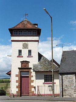
Lodge Blairhoyle, in Thornhill, is Britain's smallest purpose-built Masonic Lodge
Stirling UK location map.svg
Red pog.svg
Thornhill
Location within the Stirling council area
Population600 (mid-2020 est.) [1]
OS grid reference NS664998
Civil parish
Council area
Lieutenancy area
Country Scotland
Sovereign state United Kingdom
Post town Stirling
Postcode district FK8
Dialling code 01786
Police Scotland
Fire Scottish
Ambulance Scottish
UK Parliament
Scottish Parliament
List of places
UK
Scotland
56°10′23″N4°09′07″W / 56.173°N 4.152°W / 56.173; -4.152

Thornhill (Scottish Gaelic : Cnoc na Driseig) is a village in the Scottish council area of Stirling. It lies 14 miles north west of Stirling itself, south of Callander, east of Aberfoyle and west of Doune.

Contents

Historically part of Perthshire, the village is in the civil parish of Kincardine and the church parish of Norrieston (separated ecclesisistically from Kincardine in 1877), named from the much earlier village of Norrieston, which lay a little to the east of Thornhill. It is situated on a slight elevation at the western edge of the Carse of Stirling, an area of flat agricultural land which forms the upper part of the floodplain of the River Forth. Much of the land within the Carse was bogland until the late 18th century when concerted efforts were made to clear away the peat and expose the fertile clay soil below. Flanders Moss, the largest remaining area of lowland bog in Scotland and a site of special scientific interest, lies to the south west.

The village lies on a traditional east–west route from Dunblane to Aberfoyle [2] which passes the Old Post Cottage and was planned and founded at the end of the seventeenth century. [3]

The 2001 census population for the area covered by the Thornhill and Blairdrummond Community Council is 1,109. [4]

Thornhill has one primary school which in the session 2009-2010 had 62 pupils from the village and surrounding area. [5]

The ruins of a possible Iron Age broch lie at Boquhapple about 1 mile north of Thornhill. A mound of rubble about 30 metres (100 ft) in diameter and the earthworks are all that remain today. [6]

The name Thornhill is supposedly derived from the thorn covered ridge on which the village is situated. Thornhill was founded as an early planned village in 1696 and most buildings date from the 18th, 19th and 20th century.

It is believed to have the smallest Masonic Lodge in Scotland. [7]

Thornhill has a community hall with a main hall, meeting rooms, kitchen, changing rooms with showers and parking. The hall is available for the use of locals and other groups. [8]

Thornhill has one pub, The Lion and Unicorn, located on Main Street. It is thought to predate the founding of the village, starting life as a drovers' inn, possibly as early as 1635. [9]

Notable person

Related Research Articles

<span class="mw-page-title-main">Aberfoyle, Stirling</span> Human settlement in Scotland

Aberfoyle is a village in the historic county and registration county of Perthshire and the council area of Stirling, Scotland. The settlement lies 27 miles northwest of Glasgow.

<span class="mw-page-title-main">Perthshire</span> Historic administrative division in Scotland

Perthshire, officially the County of Perth, is a historic county and registration county in central Scotland. Geographically it extends from Strathmore in the east, to the Pass of Drumochter in the north, Rannoch Moor and Ben Lui in the west, and Aberfoyle in the south; it borders the counties of Inverness-shire and Aberdeenshire to the north, Angus to the east, Fife, Kinross-shire, Clackmannanshire, Stirlingshire and Dunbartonshire to the south and Argyllshire to the west. It was a local government county from 1890 to 1930.

<span class="mw-page-title-main">River Forth</span> River in central Scotland

The River Forth is a major river in central Scotland, 47 km (29 mi) long, which drains into the North Sea on the east coast of the country. Its drainage basin covers much of Stirlingshire in Scotland's Central Belt. The Gaelic name for the upper reach of the river, above Stirling, is Abhainn Dubh, meaning "black river". The name for the river below the tidal reach is Uisge For.

<span class="mw-page-title-main">Stirling (council area)</span> Council area of Scotland

The Stirling council area is one of the 32 council areas of Scotland, and has a population of about 93,470. It was created in 1975 as a lower-tier district within the Central region. The district covered parts of the historic counties of Stirlingshire and Perthshire, which were abolished for local government purposes. In 1996 the Central region was abolished and Stirling Council took over all local government functions within the area.

<span class="mw-page-title-main">Tillicoultry</span> Town in Clackmannanshire, Scotland

Tillicoultry is a town in Clackmannanshire, Scotland. Tillicoultry is usually referred to as Tilly by the locals.

<span class="mw-page-title-main">Fintry</span> Human settlement in Scotland

Fintry is a small riverside village in Stirlingshire, central Scotland. It is located 16 miles (26 km) south-west of Stirling and around 19 miles (31 km) north of Glasgow.

<span class="mw-page-title-main">Larbert</span> Town in Falkirk, Scotland

Larbert is a town in the Falkirk council area of Scotland. The town lies in the Forth Valley above the River Carron which flows from the west. Larbert is three miles from the shoreline of the Firth of Forth and 2+12 miles northwest of Falkirk. Stenhousemuir lies directly east of Larbert, with both settlements being contiguous and sharing certain public amenities with one another.

<span class="mw-page-title-main">Kippen</span> Human settlement in Scotland

Kippen is a village in west Stirlingshire, Scotland. It lies between the Gargunnock Hills and the Fintry Hills and overlooks the Carse of Forth to the north. The village is 9 miles west of Stirling and 20 mi (32 km) north of Glasgow. It is 4+12 mi (7 km) south-east of Loch Lomond and the Trossachs National Park, Scotland's first National Park.

<span class="mw-page-title-main">Balfron</span> Human settlement in Scotland

Balfron is a village in the Stirling council area of Scotland. It is situated near Endrick Water on the A875 road, 18 miles (29 km) west of Stirling and 16 miles (26 km) north of Glasgow. Although a rural settlement, it lies within commuting distance of Glasgow, and serves as a dormitory settlement.

<span class="mw-page-title-main">Buchlyvie</span> Human settlement in Scotland

Buchlyvie is a village in the Stirling council area of Scotland. It is situated 14 miles (23 km) west of Stirling and 18 miles (29 km) north of Glasgow. Lying within the Carse of Forth, to the north is Flanders Moss and to the south are the Campsie Fells. The village lies on the A811, which follows the line of an eighteenth-century military road between Stirling and Balloch. According to the 2001 census the village's population was 479.

<span class="mw-page-title-main">Strathblane</span> Human settlement in Scotland

Strathblane is a village and parish in the registration county of Stirlingshire, situated in the southwestern part of the Stirling council area, in central Scotland. It lies at the foothills of the Campsie Fells and the Kilpatrick Hills on the Blane Water, 12 miles (19 km) north of Glasgow, 14 miles (23 km) east-southeast of Dumbarton, and 20 miles (32 km) southwest of Stirling. Strathblane is a dormitory village for Greater Glasgow, and has a total resident population of 1,811.

<span class="mw-page-title-main">St Cyrus</span> Human settlement in Scotland

St Cyrus or Saint Cyrus, formerly Ecclesgreig is a village in the far south of Aberdeenshire, Scotland.

<span class="mw-page-title-main">Blair Drummond</span> Human settlement in Scotland

Blair Drummond is a small rural community 5 miles northwest of Stirling in the Stirling district of Scotland, predominantly located along the A84 road. Lying to the north of the River Forth, the community is within the registration county of Perthshire and the civil parish of Kincardine

<span class="mw-page-title-main">Lecropt</span> Parish in Stirling Council, Scotland

Lecropt is a rural parish lying to the west of Bridge of Allan, Scotland.

<span class="mw-page-title-main">Longforgan</span> Human settlement in Scotland

Longforgan is a village and parish in the Carse of Gowrie, in Perth and Kinross, Scotland. It lies 5 miles west of Dundee on the main A90 road.

<span class="mw-page-title-main">Blackburn, Aberdeenshire</span> Human settlement in Scotland

Blackburn is a rapidly growing village northwest of Aberdeen, Scotland, and is situated in Aberdeenshire. Local amenities include an industrial estate, primary school, nursing home, post office, Starbucks Drive Thru, local Co-op and a community hall.

<span class="mw-page-title-main">Flanders Moss</span> Area of raised bog lying in the Carse of Stirling, Scotland.

Flanders Moss is an area of raised bog lying in the Carse of Forth in west Stirlingshire, Scotland. The villages of Thornhill and Port of Menteith lie to the north with the villages of Kippen and Buchlyvie lying to the south. The moss is a National Nature Reserve, managed by NatureScot. Formed on the Carse of Stirling over 8000 years ago, it is an internationally important habitat currently undergoing active restoration. The eastern part of Flanders Moss is the largest raised bog in Europe to remain in a predominantly near-natural state.

<span class="mw-page-title-main">Strathyre</span> Human settlement in Scotland

Strathyre is a district and settlement in the Stirling local government district of Scotland. It forms the south-eastern part of the parish of Balquhidder and was, prior to the 1973 reorganisation of local government, part of Perthshire. It is within the bounds of the Loch Lomond and the Trossachs National Park. In Gaelic, the district is Srath Eadhair and the village is An t-Iomaire Riabhach or an t-Iomaire Fada.

Kincardine is a civil parish in the Scottish council area of Stirling and the former county of Perthshire in the historic district of Menteith.

References

  1. "Mid-2020 Population Estimates for Settlements and Localities in Scotland". National Records of Scotland. 31 March 2022. Retrieved 31 March 2022.
  2. Thornhill Community Trust - About Thornhill Archived March 24, 2012, at the Wayback Machine
  3. "Thornhill". VisitScotland. Retrieved 23 February 2017.
  4. "2001 CENSUS RESULTS: THORNHILL & BLAIRDRUMMOND COMMUNITY COUNCIL" (PDF). Stirling Council. January 2004. Retrieved 13 July 2014.
  5. Thornhill Primary School
  6. "Boquhapple". CANMORE. Royal Commission on the Ancient and Historical Monuments of Scotland. Retrieved 12 June 2018.
  7. "Thornhill". Gazetteer for Scotland. Retrieved 13 July 2014.
  8. "Thornhill Community Hall (Stirling)". www.thornhillcommunityhall.org.uk. Archived from the original on 28 January 2017. Retrieved 15 May 2023.
  9. "Thornhill, Stirling, Feature Page on Undiscovered Scotland". www.undiscoveredscotland.co.uk. Retrieved 16 June 2021.