River Moriston

Last updated

River Moriston
View from Torgyle Bridge - geograph.org.uk - 699655.jpg
The River Moriston looking downstream from Torgyle Bridge
Highland UK relief location map.jpg
Red pog.svg
Location of the mouth within Scottish Highlands
Location
Country Scotland
Physical characteristics
Source 
  location Loch Cluanie
  coordinates 57°08′35″N5°00′06″W / 57.1430°N 5.0016°W / 57.1430; -5.0016
Mouth  
  location
Loch Ness
  coordinates
57°12′35″N4°36′12″W / 57.2096°N 4.6033°W / 57.2096; -4.6033
River Moriston
BSicon uexKHSTa.svg
BSicon uexKHSTa.svg
BSicon POINTERg@fq.svg
BSicon uexSTR.svg
River Cluanie
BSicon POINTERg@fq.svg
BSicon uexSTR.svg
BSicon uexSTR.svg
River Loyne
BSicon uexSTR.svg
BSicon uexDOCKSa.svg
Loch Cluanie
BSicon uexDOCKSa.svg
BSicon utSTR+l.svg
BSicon uexRESVGDa.svg
BSicon utSTR+r.svg
tunnels
BSicon uexRESVGDa.svg
BSicon utSTRr.svg
BSicon uexSTR.svg
BSicon utSTR.svg
Loch Loyne
BSicon uexSTR.svg
BSicon POINTERg@fq.svg
BSicon uexSTR.svg
BSicon utSTR.svg
River Moriston
BSicon uexSTR.svg
BSicon uexSTR.svg
BSicon utSTR.svg
BSicon uexKHSTa.svg
BSicon uexSTR.svg
BSicon uexSTR.svg
BSicon utSTR.svg
BSicon uxWEIRg.svg
Dam intake and weir
BSicon uexSTR.svg
BSicon uexABZg+l.svg
BSicon uexSTRq.svg
BSicon utSTR.svg
BSicon uexSTRr.svg
Allt nam Peathrain
BSicon uexSKRZ-Au.svg
BSicon utSTR.svg
A87 Bridges
BSicon uexSTRl.svg
BSicon uexSTRq.svg
BSicon uexABZg+r.svg
BSicon utSTR.svg
River Loyne
BSicon uexSTR.svg
BSicon utSTR.svg
BSicon uexKHSTa.svg
BSicon uexKHSTa.svg
River Doe & Allt Bhuruisgidh
BSicon uexSTR.svg
BSicon utABZg+l.svg
BSicon uexSTR.svg
BSicon utSTRq.svg
BSicon uexSTR.svg
BSicon utENDEeq.svg
branch tunnel
BSicon uexSTR.svg
BSicon utSTR.svg
BSicon uxWEIRg.svg
BSicon uxWEIRg.svg
dams
BSicon uexSKRZ-Au.svg
BSicon utSTR.svg
BSicon uexABZg+l.svg
BSicon uexSTRr.svg
A887 Ceannacroc Bridge
BSicon uexSKRZ-Eu.svg
BSicon utSTR.svg
BSicon uexSTR.svg
Old Ceannacroc Bridge
BSicon uxWEIRg.svg
BSicon utSTR.svg
BSicon uexSTR.svg
weir
BSicon uxSTRbr.svg
BSicon utSTRr.svg
BSicon uexSTR.svg
Ceannacroc power station
BSicon uexABZg+l.svg
BSicon uexSTRq.svg
BSicon uexSTRr.svg
River Doe
BSicon uxSTRbl.svg
Hatchery
BSicon uexSKRZ-Au.svg
A887 bridge
BSicon uexKHSTa.svg
BSicon uexSTR+l.svg
BSicon uexSTRr.svg
Allt Phocaichain
BSicon uexSTRl.svg
BSicon uexABZg+r.svg
BSicon uexKHSTa.svg
Allt Iarairaidh
BSicon uexSTR.svg
BSicon uexSTR.svg
BSicon uexKHSTa.svg
BSicon uexBHF.svg
BSicon uexSTR.svg
BSicon uexSTR.svg
BSicon uexSTR.svg
BSicon uexRESVGa.svg
BSicon uexSTR.svg
Loch ma Stac dam
BSicon uexSTR.svg
BSicon uexSTR.svg
BSicon uexRESVGa.svg
BSicon uexSTRr.svg
BSicon uexSTR.svg
Loch Liath dam
BSicon uexSTR.svg
BSicon uexSTR.svg
BSicon uexSTR.svg
BSicon uexBHF.svg
BSicon uexSTR.svg
BSicon uexSTR.svg
BSicon uexSTR.svg
BSicon uexRESVGa.svg
BSicon uexSTR.svg
Loch a Chrathaich dam
BSicon uexSTR.svg
BSicon uexSKRZ-Au.svg
BSicon uexSTR.svg
BSicon uexSTR.svg
BSicon uexBHF.svg
A887 bridge
BSicon uexDOCKSa.svg
BSicon uexSTRr.svg
BSicon uexRESVGa.svg
BSicon uexSTR.svg
BSicon utSTRq.svg
BSicon uexSTR.svg
BSicon utENDEeq.svg
Bhlaraidh Reservoir dam
BSicon uexDOCKSm.svg
BSicon utSTR+l.svg
BSicon uexSTR.svg
BSicon utSTRr.svg
BSicon uxWEIRg.svg
BSicon uxWEIRg.svg
Dams
BSicon uexDOCKSm.svg
BSicon utSTR.svg
BSicon uexSTR.svg
BSicon uexSTR.svg
BSicon uexBHF.svg
Loch a' Mheig
BSicon uexDOCKSm.svg
BSicon BUILDINGm.svg
BSicon utSTR.svg
BSicon uexSTR.svg
BSicon uexSTR.svg
BSicon uexSTR.svg
Livishie power station
BSicon uexRESVGDa.svg
BSicon utSTRr.svg
BSicon uexSTR.svg
BSicon uexSTR.svg
BSicon uexSTR.svg
Dundreggan Reservoir
BSicon utSTR+l.svg
BSicon uxSTRbl.svg
BSicon uexSTR.svg
BSicon uexSTR.svg
BSicon uexSTR.svg
Glenmoriston power station
BSicon utSTR.svg
BSicon uexSTR.svg
BSicon uexSTR.svg
BSicon uexSTR.svg
BSicon POINTERg@fq.svg
BSicon uexSTR.svg
Allt Saigh
BSicon utSTR.svg
BSicon uexSTR.svg
BSicon uexABZg+l.svg
BSicon uexSTRr.svg
BSicon uexSTR.svg
Allt Loch a Chrathaich
BSicon utSTR.svg
BSicon uexSTR.svg
BSicon uexSKRZ-Au.svg
BSicon uexSTRc2.svg
BSicon uexSTR3.svg
A887 bridge
BSicon utSTR.svg
BSicon uexABZg+l.svg
BSicon uexSTRq.svg
BSicon uexSTRc2.svg
BSicon uexSTRr.svg
BSicon uexSTR3+1.svg
BSicon uexSTRc4.svg
Allt Bhlaraidh
BSicon utSTR.svg
BSicon uexSKRZ-Eu.svg
BSicon uexSTR+1.svg
BSicon uexSTRc4.svg
Old Invermoriston Bridge
BSicon utSTR.svg
BSicon uexSKRZ-Au.svg
BSicon uexSTR.svg
A82 Invermoriston Bridge
BSicon utSTRl.svg
BSicon uexSTR.svg
BSicon utSTR+r.svg
BSicon uexSTR.svg
tailrace tunnel
BSicon uCONTgq.svg
BSicon uDOCKSl.svg
BSicon uDOCKSm.svg
BSicon uDOCKSm.svg
BSicon uDOCKSr.svg
BSicon uCONTfq.svg
Loch Ness

The River Moriston (Scottish Gaelic : Abhainn Mhoireastain) is a river in Inverness-shire, Scotland. It flows broadly east-north-east from the outfall of the dam at Loch Cluanie to Loch Ness. Its waters and those of its tributaries have been harnessed to generate hydro-electric power.

Contents

Route

The River Moriston begins just below the dam at the eastern end of Loch Cluanie. Flow in the river is maintained by releasing compensation water from the loch. The A887 road from Kyle of Lochalsh to Loch Ness closely follows the course of the river for much of its length, and is on the north bank at this point. A small river, the Allt nam Peathrain, flows southwards to pass under the road and join the channel on its left bank. At Bun Loyne, a bridge carries the A87 road over the river, as it heads southwards to Glen Garry and the River Garry. Below the bridge, the River Loyne joins on the right bank. This is largely compensation water released from the dam at the eastern end of Loch Loyne. The A887 road crosses to the south bank at Ceannacroc Bridge. [1] The road formerly crossed the old bridge, constructed by Thomas Telford in 1808-1811, and located a little further downstream. It consists of a main span of 50 feet (15 m) for the river and a flood arch of 36 feet (11 m). [2]

The river sweeps round in a large bend, where it is joined by the waters of the River Doe and its tributary the Allt Bhuruisgidh, both of which are dammed further upstream. The main channel continues in an east-north-easterly direction, past the hamlet of Tomchrasky on its northern bank. There is a hatchery on the right bank, and then the A887 crosses to the left bank at Torgoyle Bridge. [1] A bridge was constructed here in 1811 by Telford, but in 1818 was destroyed by a flood. A temporary wooden bridge was put in place to maintain the route, and the present three-arched structure was completed in 1823, to the design of Joseph Mitchell, who was Telford's principal inspector. The outside two arches span 48 feet (15 m) while the centre one, which is wider and higher, spans 55 feet (17 m). [3] The is extensive forest on both banks of the river, which gradually widens as it becomes part of Dundreggan Reservoir. A dam impounds the water at its eastern end, and a hydro-electric power station is located on the south bank close to the dam. [1]

The river narrows again, as it is fed with compensation water from the dam, and is joined by Allt Bhlaraidh, flowing southwards from three lochs and a reservoir, all of which are dammed. The river finally turns towards the south-east as it approached Invermoriston, the main settlement on its course. The A82 road which runs along the bank of Loch Ness [1] used to cross the river on a two-arched bridge, with another arch on the right bank of the river and a three-arched clapper bridge in the approach on the left bank. It is in line with Telford's road built for the Commission for Highland Roads and Bridges in 1808-1811, but is thought to date from the mid-18th century. [4] A replacement bridge was built in 1933, slightly further downstream. It consists of a single 90-foot (27 m) concrete span with a small flood arch, and was designed by Mears and Carcus-Wilson. [5] Below the newer bridge is a nine-sided gazebo, perched on a rocky outcrop overlooking the river. It dates from the early 19th century. [6] Shortly afterwards, the river discharges into Loch Ness. [1]

Hydro-electric power

The Garry-Moriston hydro-electric scheme was one of several constructed by the North of Scotland Hydro-Electric Board, a public body formed in 1943 to promote water power in the Highlands. They used profits from similar schemes in the southern Highlands to fund remote schemes such as this, in order to stimulate economic regeneration of the area. [7] [8] The catchment for the River Moriston, which includes Loch Loyne and Loch Cluanie, is 158 square miles (410 km2). Loch Loyne is impounded by a dam, which is 1,800 feet (550 m) long and 72 feet (22 m) high. Most of the water released from the loch passes along a tunnel and into Loch Cluanie. A small amount of electricity is generated by an induction generator in the pipeline. [9] The dam is a mass gravity dam, and construction was completed in 1956. [10] The loch covers an area of 2.43 square miles (6.3 km2), the surface level is 748 feet (228 m) above Ordnance datum (AOD), and it is relatively shallow. [11] The Cluanie dam is also a mass gravity dam, 2,215 feet (675 m) long and 133 feet (41 m) high. Compensation water for the River Moriston flows through a small power station located at the base of the dam. Both the Loyne dam and the Cluanie dam were built using ground blast furnace slag, which replaced 70 percent of the cement which would otherwise have been used, reducing the amount of Portland cement used by 40,000 long tons (41,000 t). The project was the first time that this technique had been used in Britain. [9] Loch Cluanie is much deeper than Loch Loyne. It covers an area of 4.04 square miles (1,046 ha) and its surface level is 705 feet (215 m) AOD, [12] which is 96 feet (29 m) higher than it was prior to construction of the dam. [9]

From Loch Cluanie, water is fed to a power station at Ceannacroc through a tunnel and pressure shaft. The power station was built underground and was one of the first underground stations to be constructed in the country, [9] when it was completed in 1956. This arrangement provides a head of 300 feet (90 m) and the station can generate 20 MW. [10] There is also a smaller generator in the station, which can discharge compensation water to the river when the full capacity of the station is not required. In addition to the main supply from Loch Cluanie, water from the upper reaches of the River Doe and its tributaries is captured and fed into a branch tunnel, where it can either be used by the turbine directly, or can be fed into Loch Cluanie for later use. [9]

The dam at Dundreggan reservoir Sleeping torrent - geograph.org.uk - 1218570.jpg
The dam at Dundreggan reservoir

A dam was built across the River Moriston some 9 miles (14 km) downstream of the Loch Cluanie dam in 1957, to form Dundreggan Reservoir. [9] It is a mass gravity dam 460 feet (140 m) long by 59 feet (18 m) high, [10] and creates a headpond for Glenmoriston power station which is 300 feet (91 m) below the ground, and is fed by a vertical shaft. Once the water has passed through the two 18 MW turbines, it flows into the mouth of the River Moriston through a tailrace tunnel which is 20 feet (6.1 m) in diameter and around 4 miles (6.4 km) long. The level of the reservoir is controlled by automatic sector gates. Compensation water for the river is discharged through another small power station, built into the dam. When the dam was constructed, a Borland type fish pass was included, to allow fish to move upstream beyond the structure. [9]

A third power station on the River Moriston system was constructed in 1962. The Livishie station generates 15 MW, and a head of 850 feet (259 m) [10] is provided by the Bhlaraidh Reservoir. This acts as a headpool, but its water is supplemented by supplies from Loch a Chrathaich, Loch Laith and Loch ma Stac, all of which have had their capacity increased by the construction of small dams. Transfer from these lochs is controlled remotely from Glenmoriston power station. In addition, a system of aqueducts collects water from streams flowing into the Moriston downstream of Dundreggan Reservoir, and feeds some of their flow into Bhlaraidh Reservoir. [13] Power generated by the stations is fed to Auchterewe, near Fort William, by overhead transmission lines, where there is a switching station and control centre. From Auchterewe, 132 kV lines distribute the power in several directions. Those over the Corrieyarrick Pass are very exposed, reaching a height of 2,507 feet (764 m) AOD, and high frequency pulses are injected into the lines to enable faults to be located. [14]

Benefits

The construction of the hydro-electric stations has brought some benefits to the area, which are wider than just providing electricity to remote communities. The dam at Dundreggan was built at a location where there had previously been a waterfall, [15] which made the migration of salmon up the river impossible. However, a Borland fish pass, which works in a similar way to a navigation lock, was constructed at the site, and unlike the neighbouring River Garry, where salmon stocks have suffered serious decline, salmon have established themselves on the river, and the population is stable or increasing. [16]

While the hydro-electric schemes were being constructed in both Glen Moriston and Glen Garry, the roads running through the glens were upgraded. [17] The main route from Invergarry to Kyle of Lochalsh formerly ran along Glen Garry to the hamlet of Tomdoun, turned northwards to cross Loch Loyne at a narrow point near the centre of the present loch, and continued to the north-west to the Cluanie Inn, at the western end of the present Loch Cluanie. When the level of Loch Loyne was raised, the crossing point was submerged, and a new A87 road was constructed, turning northwards from the old road near the eastern end of Loch Garry, running along part of the shore of Loch Loyne, and crossing over the River Loyne beyond the eastern end of the loch, to join the A887 Invermoriston to Kyle of Lochalsh road at Bun Loyne. [18] An original bridge became visible in 2012 due to low levels of rainfall, and corresponding low levels in the loch. [19]

Bibliography

Related Research Articles

<span class="mw-page-title-main">A87 road</span> Major road through the Highland region of Scotland

The A87 is a major road in the Highland region of Scotland.

<span class="mw-page-title-main">Loch Cluanie</span> Reservoir in Northwest Highlands, Scotland

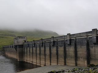
Loch Cluanie is a loch in the Northwest Highlands of Scotland at the south-east end of Glen Shiel. It is a reservoir, contained behind the Cluanie Dam, constructed by Mitchell Construction and completed in 1957 as part of the North of Scotland Hydro-Electric Board's Glenmoriston project to generate hydroelectricity. Water feeds the dam from the west via two flows, from a tunnel from the dammed Loch Loyne and via the River Moriston.

<span class="mw-page-title-main">River Tummel</span> River in Perth and Kinross, Scotland

The River Tummel is a river in Perth and Kinross, Scotland. Water from the Tummel is used in the Tummel hydro-electric power scheme, operated by SSE.

<span class="mw-page-title-main">Falls of Foyers</span> Waterfall in Highland, Scotland

The Falls of Foyers are two waterfalls on the River Foyers, which feeds Loch Ness, in Highland, Scotland, United Kingdom. They are located on the lower portion of the River Foyers, and consist of the upper falls, with a drop of 46 feet (14 m) and the lower falls, which drop 98 feet (30 m).

<span class="mw-page-title-main">Galloway hydro-electric power scheme</span>

The Galloway hydro-electric power scheme is a network of dams and hydro-electric power stations in Galloway, south west Scotland. It was built between 1930 and 1936.

<span class="mw-page-title-main">Loch Tummel</span> Freshwater loch in Perth and Kinross, Scotland

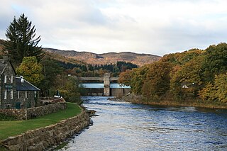
Loch Tummel is a long, narrow loch, seven kilometres northwest of Pitlochry in the council area of Perth and Kinross, Scotland. It is fed and drained by the River Tummel, which flows into the River Tay about 13 km (8 mi) south-east of the Clunie Dam at the loch's eastern end.

<span class="mw-page-title-main">River Shin</span> River in northern Scotland

The River Shin is a river in the Scottish North West Highlands.

<span class="mw-page-title-main">North of Scotland Hydro-Electric Board</span> UK hydroelectric government body (1943–1990)

The North of Scotland Hydro-Electric Board (1943–1990) was founded to design, construct and manage hydroelectricity projects in the Highlands of Scotland. It is regarded as one of the major achievements of Scottish politician Thomas Johnston, who chaired the board from 1945 to 1959.

<span class="mw-page-title-main">Tomdoun</span>

Tomdoun is a settlement on the north side of the River Garry, near the western end of Loch Garry, in Glen Garry in the Highlands of Scotland. The name comes from the Gaelic for "the brown hillock".

<span class="mw-page-title-main">River Conon</span> River in Scotland

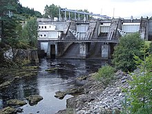
The River Conon is a river in the Highlands of Scotland. It begins at Loch Luichart, and flows in a south-easterly direction to be joined by the River Meig at Scatwell before passing through Loch Achonachie. It is joined by the Black Water at Moy Bridge, and the River Orrin at Urray, before flowing past Conon Bridge and into the Cromarty Firth.

<span class="mw-page-title-main">Glenmoriston</span>

Glenmoriston or Glen Moriston is a river glen in the Scottish Highlands, that runs from Loch Ness, at the village of Invermoriston, westwards to Loch Cluanie, where it meets with Glen Shiel. The A887 and A87 roads pass through Glenmoriston.

<span class="mw-page-title-main">Tummel hydro-electric power scheme</span> Dam in Perth and Inverness

The Tummel hydro-electric power scheme is an interconnected network of dams, power stations, aqueducts and electric power transmission in the Grampian Mountains of Scotland. Roughly bounded by Dalwhinnie in the north, Rannoch Moor in the west and Pitlochry in the east it comprises a water catchment area of around 1,800 square kilometres (690 sq mi) and primary water storage at Loch Ericht, Loch Errochty, Loch Rannoch and Loch Tummel, in Perth and Kinross. Water, depending on where it originates and the path it takes, may pass through as many as five of the schemes nine power stations as it progresses from north-west to south-east. The scheme was constructed in the 1940s and 50s incorporating some earlier sites. It is currently managed by SSE plc.

The Affric / Beauly hydro-electric power scheme for the generation of hydro-electric power is located in the western Highlands of Scotland. It is based around Glen Strathfarrar, Glen Cannich and Glen Affric, and Strathglass further downstream.

<span class="mw-page-title-main">Loch Errochty</span> Loch in Perth and Kinross, Scotland

Loch Errochty is a man made freshwater loch situated within the Perth and Kinross council area at the edge of the Scottish Highlands near the Highland Boundary Fault where the topography changes to lowland.

<span class="mw-page-title-main">Dunalastair Water</span> Freshwater loch, reservoir in Perth and Kinross, Scotland

Dunalastair Water is an entirely man made reservoir in Scotland which lies between Loch Rannoch and Loch Tummel in Strath Tummel in Perth and Kinross council area. The loch provides water power for the Tummel hydroelectricity power station and has the reputation as one of the best wild trout fishing locations in the United Kingdom.

<span class="mw-page-title-main">Loch Ness</span> Lake in Scotland, United Kingdom

Loch Ness is a large freshwater loch in the Scottish Highlands extending for approximately 37 kilometres southwest of Inverness. It takes its name from the River Ness, which flows from the northern end. Loch Ness is best known for claimed sightings of the cryptozoological Loch Ness Monster, also known affectionately as "Nessie". It is one of a series of interconnected, murky bodies of water in Scotland; its water visibility is exceptionally low due to a high peat content in the surrounding soil. The southern end connects to Loch Oich by the River Oich and a section of the Caledonian Canal. The northern end connects to Loch Dochfour via the River Ness, which then ultimately leads to the North Sea via the Moray Firth.

<span class="mw-page-title-main">River Garry, Inverness-shire</span> River in Scotland

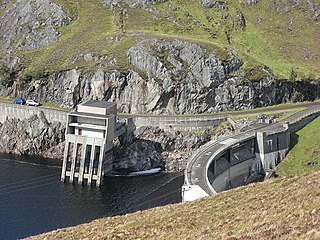
The River Garry in Inverness-shire is a Scottish river punctuated by two long Lochs, in the region of Lochaber. It flows broadly west to east through Glen Garry, starting in a wilderness to the east of Knoydart and ending at Loch Oich in the Great Glen, which forms part of the Caledonian Canal. There are a few tiny settlements within Glen Garry, but the only village of any size near to the river is Invergarry, at its mouth. Loch Quoich at the western end of the watercourse is dammed by the largest mass earth fill dam in Scotland, and supplies water to Quoich hydroelectric power station. Loch Garry is dammed by a much smaller dam in the gorge where the river begins its descent to Invergarry, and supplies water to Invergarry hydroelectric power station, close to the mouth of the river. Both hydroelectric schemes were built in the 1950s, with the aim of stimulating economic regeneration in the area. They have altered the ecology of the river, as both lochs were made considerably bigger as a result of constructing the dams.

<span class="mw-page-title-main">Loch Sloy Hydro-Electric Scheme</span> Dam in Argyll and Bute

The Loch Sloy Hydro-Electric Scheme is a hydro-electric facility situated between Loch Sloy and Inveruglas on the west bank of Loch Lomond in Scotland.

<span class="mw-page-title-main">Loch Tarsan</span> Reservoir. in Argyll and Bute, Scotland.

Loch Tarsan; is a freshwater loch and impounding reservoir located 13 kilometres Northwest of Dunoon, on the Cowal peninsula in Argyll and Bute, Scotland. This three-armed Reservoir extends into both Glen Tarsan and Glen Lean. It supplies water to the Striven Hydro-Electric Scheme. The larger of the two dams is 17.6 metres high and was completed in 1953. The water that is collected in the loch, are piped to the hydro-electric generating station, located at Ardtaraig, at the head of Loch Striven.

<span class="mw-page-title-main">Loch Loyne</span> Reservoir in Northwest Highlands, Scotland

Loch Loyne is a loch in the Northwest Highlands of Scotland. Loch Loyne lies between Glen Garry and Glen Cluanie. The A87 road runs beside the eastern side of the loch.

References

Commons-logo.svg Media related to River Moriston at Wikimedia Commons