River Morar

Last updated

River Morar
Jetty on River Morar - geograph.org.uk - 511564.jpg
Moorings on the upper section of the river
Highland UK relief location map.jpg
Red pog.svg
Location of the mouth within Scottish Highlands
Location
Country Scotland
Physical characteristics
Source 
  location Loch Morar
  coordinates 56°58′01″N5°48′33″W / 56.9669°N 5.8093°W / 56.9669; -5.8093
Mouth  
  location
Morar Bay
  coordinates
56°58′12″N5°50′14″W / 56.9700°N 5.8372°W / 56.9700; -5.8372
River Morar
BSicon uDOCKSa.svg
Loch Morar
BSicon uDOCKSm.svg
BSicon uDOCKSm.svg
BSicon uDOCKSe.svg
BSicon uddSTRl.svg
Moorings
BSicon uexSTR.svg
BSicon uxSTRbr.svg
BSicon utSTR+r.svg
Morar power station
BSicon uxWEIRg.svg
BSicon utSTR.svg
Weir
BSicon uxWEIRg@G.svg
BSicon utSTR.svg
Falls of Morar
BSicon uexSTR.svg
BSicon utSTR+l.svg
BSicon utSTRr.svg
Tailrace
BSicon RY+r.svg
BSicon uexSTR.svg
BSicon SKRZ-Yoq.svg
BSicon uxmKRZu.svg
West Highland Line bridge
BSicon RYl.svg
BSicon uexSKRZ-Yu.svg
B8008 bridge
BSicon uexSKRZ-Au.svg
A830 Morar bypass
BSicon uexVEEf.svg
Morar Bay
BSicon uDOCKSm.svg
BSicon uDOCKSm.svg
BSicon uDOCKSm.svg
Sound of Sleat
Estuary of Morar Bay Morar Estuary - geograph.org.uk - 189013.jpg
Estuary of Morar Bay
Steam train crossing the railway viaduct Holiday steam (geograph 3983689).jpg
Steam train crossing the railway viaduct

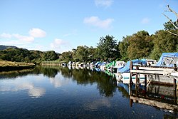
The River Morar is a river that flows from Loch Morar in the west Highlands of Scotland. It flows from the western end of the loch to the estuary of Morar Bay, an inlet of the Sound of Sleat. It is one of Scotland's shortest rivers, and is known for its white sands beaches where it flows through Morar Bay.

Contents

The river is crossed by three bridges, and is the site of a hydro-electric power station, built as part of the first constructional scheme promoted by the newly-formed North of Scotland Hydro-Electric Board, to demonstrate its commitment to supplying the remote areas of Scotland with electricity. It was commissioned in 1948.

Course

The course of the River Morar is about 0.5 miles (0.8 km) long from Loch Morar to below the bridge carrying the A830 trunk road, and is one of the shortest rivers in Scotland. However, when the tide is out, it flows in a single channel across the sands of Morar Bay, for another 1.5 miles (2.4 km), [1] and this section is labelled River Morar by the Ordnance Survey. [2] The surface level of Loch Morar is 46 feet (14 m) above Ordnance datum (AOD), and the river descends through this height to reach the sea at the Sound of Sleet. [3]

At the top end of the river, there are a series of jetties on the right bank, which provide moorings for boats using the loch. The river heads south, and then turns to the west. [2] A weir and sluice control the flow to the hydroelectric station on the left bank. The river then tumbles down a rocky section, known as the Falls of Morar, although the flow down the falls is considerably less than it was before the hydroelectric plant was built. The power station discharges its water back into the river below the main part of the falls, and a fish ladder allows salmon and trout to negotiate the rise to reach Loch Morar. [4]

The river is crossed by three bridges, the upper most of which is a railway viaduct built by the West Highland Railway which opened its route from Banavie to Mallaig in 1901. The viaduct consists of four arches, is made of massed concrete, and was completed in 1897. It now carries the West Highland Line and is a Category B listed building. [5] The main arch spanning the river is 90 feet (27 m), a second smaller arch carries the railway over the road on the north side of the river, and there are arches at both ends which are smaller still. [6] The second bridge carries the B8008 road which runs through the village of Morar. It was formerly part of the main road from Fort William to Mallaig. The present bridge is close to the railway viaduct, [2] and is built of stone. [7] Prior to 1915, the road bridge was a little further downstream, but was replaced at some point. The newer bridge is the normal upstream limit to which tides flow. [8] The third bridge carries the A830 road, and was constructed in 1997 when the road was upgraded. It bypasses the village altogether. [9]

Below the road bridge, the river channel is flanked by white sandy beaches at low tide, known as the Silver Sands of Morar. [10] The River Morar forms the boundary between the parishes of Glenelg, to the north, and Arisaig and Moidart, to the south. [11]

Falls of Morar

As the River Morar crosses over the rock bar at the end of the loch it forms a series of waterfalls known as the Falls of Morar. [12]

Hydroelectric power station

A 750 kW hydroelectric power station with a hydraulic head of 16 feet (4.9 m) was built on the River Morar in 1948. [13] [14]

The North of Scotland Hydro-Electric Board was created as a result of the Hydro-electric Development (Scotland) Act 1943, [15] an Act championed by the politician Tom Johnston during his time as Secretary of State for Scotland. [16] Johnston's vision was for a public body that could build hydro-electric stations throughout the Highlands. Profits made by selling bulk electricity to the Scottish lowlands would be used to fund "the economic development and social improvement of the North of Scotland." Private consumers would be offered a supply of cheap electricity, and their connection to that supply would not reflect the actual cost of its provision in remote and sparsely-populated areas. [17]

Lord Airlie, who had initially been critical of the 1943 Act because its scope was too limited, was the first chairman of the new Board. Edward MacColl, an engineer with wide experience of hydro-electric projects and electrical distribution networks, was deputy chairman and chief executive. [18] It soon became clear that MacColl intended to push ahead with the aspirations of the Act at breakneck speeds. He produced a list of 102 potential sites in just three months, [19] and in June 1944, the first constructional scheme was published. This was for the Loch Sloy scheme, which had a ready market for bulk supplies to nearby Clydeside, but it included two smaller schemes, to demonstrate the Board's commitment to supplying remote areas. These were at Morar and Kyle of Lochalsh. The estimated cost of the two smaller schemes was £0.5 million, compared to £4.1 million for the Sloy development. Although there were no objections to the two smaller schemes, implementation was delayed, because there was vigorous opposition to the Sloy scheme, and a public inquiry was held to consider this. [20] John Cameron KC decided that the objectors had failed to convince him that the scheme was not in the public interest, and the three schemes were authorised on 28 March 1945. [21]

To mark the start of the smaller projects, pole raising ceremonies were held in May 1946 at Morar and at Nostie Bridge, where the Lochalsh station would be built. The Morar scheme would be built beside the Falls of Morar, and a token electricity pole was raised, which would become part of the distribution network for an area which would reach from Mallaig to the north down to Loch Ailort in the south. [22] Both Tom Johnston and Edward MacColl were present, with Lady Hermione Cameron of Locheil assisting with the ceremony. [23]

The intake sluice for the Morar hydro-electric station Loch Morar hydro station - geograph.org.uk - 909935.jpg
The intake sluice for the Morar hydro-electric station

The original plans for both sites were brick structures, but James Shearer, one of three members of the Panel of Architectural Advisors to the Board, [24] who was tasked with the architectural work at Lochalsh, noticed that all local buildings were made of local stone, in a style he called cottage architecture, [25] and asked MacColl whether stone could be used for the power station, despite its extra cost and the fact that working with stone was a dying art. MacColl readily agreed, and this formed a policy for most of the Board's projects. [26] Wood states that Shearer was also the architect for the Morar station, [27] but Shearer states that it was another of the Panel of Architectural Advisors, Reginald Fairlie, who designed Morar. It too was built of stone, and both stations were officially opened on 21 December 1948, [28] becoming the first stations built by the Board to become operational. [29] At Morar a local crofter called Mrs Catherine MacKenzie inaugurated the station, by operating a wheel to let water into the turbines. She said, in Gaelic, "Let light and power come to the crofts”. ("Gun tigeadh Solus agus Neart an dealain dhionnsuich gach crout.") [30] [29]

A small dam was constructed, which raised the level of Loch Morar by 3 feet (0.9 m), but because of the location of the falls, the head for the Kaplan turbines is 16 feet (4.9 m). [31] The small change in level represents a significant increase in the volume of water stored, as the loch covers 10.36 square miles (26.83 km2). [32] The dam includes a drum gate on the spillway, which operates automatically. A fish ladder was constructed around the dam to ensure that trout and salmon could still reach Loch Morar. The power station is located in a cavern near the falls, with only the doorway and a retaining wall visible. [33]

Operation

In 2002, the Renewables Obligation (Scotland) legislation was introduced. It was conceived as a way to promote the development of small-scale hydro-electric, wave power, tidal power, photovoltaics, wind power and biomas schemes, but by the time it came into force, the definition of small scale had been increased from 5 MW to 10 MW and then 20 MW, and existing hydro-electric stations that had been refurbished to improve efficiency could be included. [34] Morar at 0.75 MW thus qualified, and between 2005 and 2007 the station qualified for 6,833 Renewable Obligation Certificates, generating a subsidy for SSE of over £332,000. [35] In 2007 the station operated at an average load factor of 48.7 percent. [36]

Related Research Articles

<span class="mw-page-title-main">Loch Morar</span> A lake in Lochaber, Scotland

Loch Morar is a freshwater loch in Lochaber, Highland, Scotland. It is the fifth-largest loch by surface area in Scotland, at 26.7 km2 (10.3 sq mi), and the deepest freshwater body in the British Isles with a maximum depth of 310 m (1,017 ft). The loch was created by glacial action around 10,000 years ago, and has a surface elevation of 9 metres (30 ft) above sea level. It separates the traditional district of North Morar, from Arisaig and Moidart.

<span class="mw-page-title-main">North of Scotland Hydro-Electric Board</span> UK hydroelectric government body (1943–1990)

The North of Scotland Hydro-Electric Board (1943–1990) was founded to design, construct and manage hydroelectricity projects in the Highlands of Scotland. It is regarded as one of the major achievements of Scottish politician Thomas Johnston, who chaired the board from 1945 to 1959.

<span class="mw-page-title-main">West Highland Railway</span> Former railway company in Scotland

The West Highland Railway was a railway company that constructed a railway line from Craigendoran to Fort William and Mallaig. The line was built through remote and difficult terrain in two stages: the section from Craigendoran to Fort William opened in 1894, with a short extension to Banavie on the Caledonian Canal opening in 1895.

<span class="mw-page-title-main">River Conon</span> River in Scotland

The River Conon is a river in the Highlands of Scotland. It begins at Loch Luichart, and flows in a south-easterly direction to be joined by the River Meig at Scatwell before passing through Loch Achonachie. It is joined by the Black Water at Moy Bridge, and the River Orrin at Urray, before flowing past Conon Bridge and into the Cromarty Firth.

<span class="mw-page-title-main">Affric-Beauly hydro-electric power scheme</span> Power stations on River Affric and River Beauly in Scottish Highlands

The Affric-Beauly hydro-electric power scheme for the generation of hydro-electric power is located in the western Highlands of Scotland. It is based around Glen Strathfarrar, Glen Cannich and Glen Affric, and Strathglass further downstream.

<span class="mw-page-title-main">Nostie</span> Human settlement and power station in Scotland

Nostie is a small remote hamlet, lying on Nostie Bay, an inlet at the northeastern end of the sea loch, Loch Alsh in the Scottish Highlands and is in the council area of Highland. Nostie lies a short distance from one of Scotland's popular tourist attractions, Eilean Donan Castle.

<span class="mw-page-title-main">River Garry, Inverness-shire</span> River and power stations in Scotland

The River Garry in Inverness-shire is a Scottish river punctuated by two long Lochs, in the region of Lochaber. It flows broadly west to east through Glen Garry, starting in a wilderness to the east of Knoydart and ending at Loch Oich in the Great Glen, which forms part of the Caledonian Canal. There are a few tiny settlements within Glen Garry, but the only village of any size near to the river is Invergarry, at its mouth. Loch Quoich at the western end of the watercourse is dammed by the largest mass earth fill dam in Scotland, and supplies water to Quoich hydroelectric power station. Loch Garry is dammed by a much smaller dam in the gorge where the river begins its descent to Invergarry, and supplies water to Invergarry hydroelectric power station, close to the mouth of the river. Both hydroelectric schemes were built in the 1950s, with the aim of stimulating economic regeneration in the area. They have altered the ecology of the river, as both lochs were made considerably bigger as a result of constructing the dams.

<span class="mw-page-title-main">Loch Sloy Hydro-Electric Scheme</span> Dam in Argyll and Bute

The Loch Sloy Hydro-Electric Scheme is a hydro-electric facility situated between Loch Sloy and Inveruglas on the west bank of Loch Lomond in Scotland.

<span class="mw-page-title-main">Breadalbane Hydro-Electric Scheme</span> Multiple power stations in Scotland

The Breadalbane Hydro-Electric Scheme is a hydroelectric scheme in the Breadalbane area of Perthshire, Scotland. It comprises seven power stations which generate 120MW of power from the dams around Loch Lyon, Loch Earn and Loch Tay.

<span class="mw-page-title-main">Morar Railway Viaduct</span> Bridge

The Morar Railway Viaduct is a railway viaduct that carries the West Highland Line over the River Morar.

Inveruglas was a remote temporary private railway station near the hamlet of Inveruglas, Argyll and Bute, Scotland. Opened in 1945 by the LNER, it was built in connection with the construction of the Sloy Hydro-Electric facility and was located on the Ardlui side of the Inveruglas Viaduct and recorded to be out of use by around 1948.

<span class="mw-page-title-main">Edward MacColl</span> Scottish engineer (1882–1951)

Edward MacColl, later Sir Edward MacColl, was a Scottish engineer, whose greatest achievements were made during the time he was Vice Chairman and chief executive officer for the North of Scotland Hydro-Electric Board. He was knighted in 1949, and died on 15 July 1951, the day before his wife Lady Margaret MacColl was due to perform the formal opening of the Tummel hydro-electric power scheme.

<span class="mw-page-title-main">Chliostair Hydro-Electric Scheme</span> Power station on Harris, Outer Hebrides, Scotland

Chliostair Hydro-Electric Scheme is a small scheme promoted by the North of Scotland Hydro-Electric Board on Harris, Outer Hebrides. It consists of a single power station powered with water from Loch Chliostair, and was commissioned in 1960.

<span class="mw-page-title-main">Gisla Hydro-Electric Scheme</span> Power station on Lewis, Outer Hebrides, Scotland

Gisla Hydro-Electric Scheme was a small scheme promoted by the North of Scotland Hydro-Electric Board on the Isle of Lewis, Outer Hebrides, Scotland. It consisted of a single power station powered with water from Loch Coirceabhat, and was commissioned in 1960.

<span class="mw-page-title-main">Mucomir Hydro-Electric Scheme</span> Power station near Spean Bridge, Scotland

Mucomir Hydro-Electric Scheme is a small-scale hydro-electric power station, built by the North of Scotland Hydro-Electric Board and commissioned in 1962. It is located on the Mucomir Cut, a waterway created by Thomas Telford during the building of the Caledonian Canal to replace the existing coarse of the River Lochy below Loch Lochy, so that the old course could be used for the canal. The power station was substantially upgraded in 2017.

<span class="mw-page-title-main">Shira Hydro-Electric Scheme</span> Power stations near Loch Fyne, Scotland

The Shira Hydro-Electric Scheme is a project initiated by the North of Scotland Hydro-Electric Board to use the waters of the River Shira, the River Fyne and other small streams to generate hydroelectricity. It is located between Loch Fyne and Loch Awe in Argyll and Bute, western Scotland. It consists of three power stations and three impounding dams.

<span class="mw-page-title-main">Awe Hydro-Electric Scheme</span> Power stations near Loch Awe, Scotland

The Awe Hydro-Electric Scheme was the penultimate scheme developed by the North of Scotland Hydro-Electric Board. It centres around Loch Awe, in Argyll and Bute, on the southern edge of the Scottish Highlands. It consists of three power stations, two conventional hydro-electric stations, and the Cruachan power station, the first large pumped storage scheme built by the Board. It was completed in 1965.

<span class="mw-page-title-main">Lussa Hydro-Electric Scheme</span> Power station near Peninver, Scotland

Lussa Hydro-Electric Scheme is a small-scale hydro-electric power station, built by the North of Scotland Hydro-Electric Board and commissioned in 1956. It is located near Peninver on the Kintyre peninsula, part of Argyll and Bute in Scotland. It was originally designed to supply power to Campbeltown, but is now connected to the National Grid.

<span class="mw-page-title-main">Striven Hydro-Electric Scheme</span> Power station near Ardtaraig, Scotland

Striven Hydro-Electric Scheme is a small-scale hydro-electric power station, built by the North of Scotland Hydro-Electric Board and commissioned in 1951. It is located near Ardtaraig on the Cowal peninsula, part of Argyll and Bute in Scotland. It is sometimes known as the Cowal Hydro-Electric Scheme. It was originally designed to supply power to the remote communities on the peninsula, but is now connected to the National Grid.

<span class="mw-page-title-main">Kerry Falls Hydro-Electric Scheme</span> Power station near Peninver, Scotland

Kerry Falls Hydro-Electric Scheme, sometimes known as Gairloch is a small-scale hydro-electric power station, built by the North of Scotland Hydro-Electric Board and commissioned in 1952. It is located near Gairloch in Wester Ross, part of the Highlands of Scotland. It was originally designed to supply power to local communities in this remote area, but is now connected to the National Grid.

References

  1. "River Morar". Gazetteer for Scotland. Archived from the original on 2 July 2022.
  2. 1 2 3 Ordnance Survey, 1:25000 map
  3. "Loch Morar Water body ID 21466". UK Centre for Ecology and Hydrology.
  4. "Mapping for River Morar". Heritage Environment Scotland.
  5. Historic Environment Scotland. "Morar, Falls of Morar Railway Viaduct over River Morar (Category B Listed Building) (LB296)" . Retrieved 28 March 2019.
  6. "Morar Viaduct". RailScot. Archived from the original on 12 June 2023.
  7. "Morar, road bridge over River Morar". Canmore.
  8. Ordnance Survey, Six inch map, 1888-1913
  9. "Morar". Undiscovered Scotland. Archived from the original on 11 June 2023.
  10. "Silver Sands of Morar". Visit Scotland. Archived from the original on 5 March 2022.
  11. "Morar, Falls of Morar Viaduct". Canmore. Archived from the original on 16 December 2019.
  12. Scotland. Landmark Pub. 1998. p. 219. ISBN   978-1-901522-18-1.
  13. "Morar Power Station". scottish-places.info. Archived from the original on 10 June 2023. Retrieved 13 July 2014.
  14. "Morar Dam, Hydro-electric Power Scheme". scotlandsplaces.gov.uk. Archived from the original on 4 March 2016. Retrieved 13 July 2014.
  15. Payne 1988, pp. 50, 298.
  16. Miller 2002, pp. 19–20.
  17. Wood 2002, pp. 58–59.
  18. Payne 1988, pp. 50–51.
  19. Payne 1988, p. 55.
  20. Payne 1988, pp. 60–61.
  21. Payne 1988, p. 63.
  22. "Hydro-electric pole raising ceremony, Morar". Am Baile - Highland History and Culture. Archived from the original on 9 June 2023.
  23. "Hydro-electric pole raising ceremony, Morar". Am Baile - Highland History and Culture. Archived from the original on 9 June 2023.
  24. Payne 1988, p. 54.
  25. Fraser 1956, p. 39.
  26. Fraser 1956, p. 40.
  27. Wood 2002, p. 80.
  28. Fraser 1956, p. 41.
  29. 1 2 Biswas 1965, p. 28.
  30. "70 years since first highland hydro switch-ons". SSE Renewables. 21 December 2018. Archived from the original on 8 August 2022.
  31. Paxton & Shipway 2007, p. 188.
  32. "Loch Morar Water body ID 21466". UK Centre for Ecology and Hydrology.
  33. Paxton & Shipway 2007, pp. 188–189.
  34. Swap 2005, pp. 5–7.
  35. Dekker 2008, p. 28.
  36. Dekker 2008, p. 133.

Bibliography

Commons-logo.svg Media related to River Morar at Wikimedia Commons