A830 road

Last updated

UK road A830.svg
A830
The road to the Isles
The Glasnacardoch turning off the A830 - geograph.org.uk - 1291636.jpg
The A830 between Arisaig and Mallaig
Route information
Length46 mi (74 km)
Major junctions
West end Mallaig
Major intersectionsUK road A82.svg A82
UK road A861.svg A861
East end Fort William
Location
Country United Kingdom
Road network
UK road A828.svg A828 UK road A831.svg A831

The A830, also known as the Road to the Isles (though it forms only a part of the historic route) is a major road in Lochaber, Scottish Highlands. It connects the town of Fort William to the port of Mallaig.

Contents

Route

The A830 is 46 miles long. Throughout its length, the road follows the route of the West Highland Line from Fort William to Mallaig. It starts at a junction on the A82 north of Fort William and immediately crosses the River Lochy over the Victoria Bridge. The road passes through several small settlements, including Corpach, Glenfinnan and Arisaig and bypasses the village of Morar. It also follows the shorelines of Loch Eil and Loch Eilt, and passes between a series of several glens between these. [1] [2] [3]

The road ends at the quayside in the port of Mallaig adjacent to the railway station with onward ferry services to the isles of Muck, Eigg, Rùm, Canna, Skye and South Uist, and a ferry across to the neighbouring peninsula at Inverie which although on the mainland has no other road access. [1] [2]

History

The A830 next to Larichmore Viaduct in 2005, when it was still a single-track road Larichmore Viaduct and the A830 - geograph.org.uk - 37338.jpg
The A830 next to Larichmore Viaduct in 2005, when it was still a single-track road

The historic Road to the Isles is an ancient drove road which leaves General Wade's military road from Stirling to Inverness at Tummel Bridge, along the northern banks of the River Tummel and Loch Rannoch roughly along the present day B846. Where today's road runs out the old road continued over Rannoch Moor past Corrour Old Lodge towards Kings House on the A82, over the Devil's Staircase and past Kinlochleven, to meet the present A830 at Fort William.

Before the 19th century, there was no established road beyond Glenfinnan. The area beyond this to Mallaig was known as the Na Garbh-Chriochain (The Rough Bounds) and was part of the Lordship of the Isles of Clan Donald, then part of the estates of Clan Macdonald of Clanranald. In 1803, Thomas Telford campaigned for government funding to build a "Parliamentary Road" across the estate from Banavie and Corpach towards Arisaig. The road was described as the "Loch-na-Gaul" road. [4]

The road was constructed by Thomas Telford in the early 19th century. It remained a single-track road throughout most of the 20th century, with the final section being upgraded in 2009. As the Road to the Isles, it has been celebrated as a historic part of Scottish culture.

In the late 1930s, a proposal was put forward in parliament to extend the A830 along the coast of the mainland as far as Kyle of Lochalsh. This was dismissed as being prohibitively expensive and of little practical use. [5]

The road was predominantly single-track until the late 20th century. By 1954, a 6-long-ton (6.1 t) weight limit had been imposed on the road. [6] while a report in 1965 showed there were still 30 miles (48 km) of single-track along the route. [7] In 1969, the section between Craigag and Glenfinnan was widened, and a new bridge over the Caledonian Canal at Banavie was built the following year. [8] The poor quality of the A830 enabled the West Highland Line to remain open; it was marked for closure in the Beeching Report but this was not done because it was impractical to run a replacement bus service along the parallel road. [9] In August 1991, a group of protestors, organised by a local councillor, blockaded the road as a protest over lack of improvements. [10]

In 2007, the road was assessed by the Institute of Advanced Motorists as being 1 of 11 roads in the UK having a "1 star" dangerous section along it. [11] In April 2009, the final single-track section of A830 between Arisaig and Lochailort (the only such example left on a British trunk road) was bypassed by a modern replacement as part of a £23.4m upgrade. [10] The 7.4-mile (11.9 km) bypassed section has been handed to the local authority for maintenance and designated the B8008. [12]

Culture

BBC programme Countryfile 2008

On 25 May 2008 the road was featured in the BBC TV programme Countryfile . [13]

Songs

There is a traditional Scottish song about the road, called The Road to the Isles . The lyrics mention locations the road passes, including (in order): the Cuillin Hills, Tummel, Loch Rannoch, Lochaber, Shiel, Ailort, Morar, the Skerries and the Lews.

A satirical song about the road, "The 8-3-0," was written by Ian McCalman (of the Scottish folk group The McCalmans) and published in 1993, before the road's widening. The song lampoons the "single track" nature of the A-status road and depicts unsuspecting tourists dodging tourist buses and fish vans, and returning from Mallaig by train instead. [14]

Related Research Articles

<span class="mw-page-title-main">Fort William, Highland</span> Town in the Highlands of Scotland

Fort William formerly and, , formerly is a town in Lochaber in the Scottish Highlands, located on the eastern shore of Loch Linnhe. At the 2011 census, Fort William had a population of 10,459, making it the second largest settlement in both the Highland council area, and the whole of the Scottish Highlands; only the city of Inverness has a larger population.

<span class="mw-page-title-main">Back of Keppoch</span> Human settlement in Scotland

Back of Keppoch is a small coastal settlement in the northwest Scottish Highlands, 40 miles west of Fort William near to the A830 road to Mallaig.

<span class="mw-page-title-main">Mallaig</span> Scottish Highland port

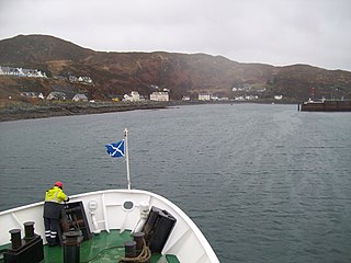
Mallaig is a port in Lochaber, on the west coast of the Highlands of Scotland. The local railway station, Mallaig, is the terminus of the West Highland railway line and the town is linked to Fort William by the A830 road – the "Road to the Isles".

<span class="mw-page-title-main">West Highland Line</span> Railway line in Scotland

The West Highland Line is a railway line linking the ports of Mallaig and Oban in the Scottish Highlands to Glasgow in Central Scotland. The line was voted the top rail journey in the world by readers of independent travel magazine Wanderlust in 2009, ahead of the notable Trans-Siberian line in Russia and the Cuzco to Machu Picchu line in Peru. The ScotRail website has since reported that the line has been voted the most scenic railway line in the world for the second year running.

<span class="mw-page-title-main">Corrour railway station</span> Railway station in the Scottish Highlands

Corrour railway station is on the West Highland Line, near Loch Ossian on the Corrour Estate, in the Highland Region of Scotland. It is the highest mainline railway station in the United Kingdom. It is located between Rannoch and Tulloch, and is sited 71 miles 54 chains (115.3 km) from Craigendoran Junction, near Helensburgh. ScotRail manage the station and provide most services, along with Caledonian Sleeper.

Arisaig is a village in Lochaber, Inverness-shire. It lies 7 miles south of Mallaig on the west coast of the Scottish Highlands, within the Rough Bounds. Arisaig is also the traditional name for part of the surrounding peninsula south of Loch Morar, extending east to Moidart. Etymologically, Arisaig means "safe bay". It lies in the Scottish council area of Highland and has a population of about 300.

<span class="mw-page-title-main">Morar</span> Human settlement in Scotland

Morar is a small village on the west coast of Scotland, 3 miles (5 km) south of Mallaig. The name Morar is also applied to the northern part of the peninsula containing the village, though North Morar is more usual. The coastline of the area forms part of the Morar, Moidart and Ardnamurchan National Scenic Area, one of 40 such areas in Scotland, which are defined so as to identify areas of exceptional scenery and to ensure its protection by restricting certain forms of development.

<span class="mw-page-title-main">Arisaig railway station</span> Railway station in the Highlands of Scotland

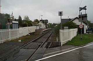
Arisaig railway station serves the village of Arisaig on the west coast of the Highland region of Scotland. This station is on the West Highland Line, measured 32 miles 2 chains (51.5 km) from the former Banavie Junction, near Fort William, between Beasdale and Morar on the way to Mallaig. The westernmost station on the Network Rail network, it is the only one of the four cardinal points of the national network that is not a terminus. ScotRail, who manage the station, operate all services.

<span class="mw-page-title-main">Rannoch railway station</span> Railway station in Perth and Kinross, Scotland

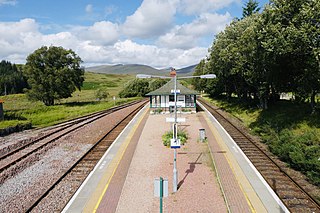
Rannoch railway station, on the West Highland Line, serves the area of Rannoch in Perth and Kinross, Scotland. In 2017, Simon Jenkins reported it to be one of the best 10 stations in Britain. It is situated between Corrour and Bridge of Orchy, 64 miles 36 chains (103.7 km) from Craigendoran Junction, near Helensburgh. ScotRail manage the station and operate most services, along with Caledonian Sleeper.

<span class="mw-page-title-main">Banavie railway station</span> Railway station in the Highlands of Scotland

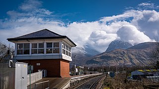
Banavie railway station is a railway station on the West Highland Line serving the village of Banavie, although it is much closer to Caol, Scotland. It is sited between Corpach and Fort William, 0 miles 22 chains (0.44 km) from Banavie Junction, just north of Fort William. To continue on to the next station at Corpach, trains must pass over the Caledonian Canal at Neptune's Staircase, a popular tourist attraction. ScotRail provide all services at, and manage, the station.

<span class="mw-page-title-main">Corpach railway station</span> Railway station in the Scottish Highlands

Corpach railway station is a railway station serving the village of Corpach in the Highland region of Scotland. This station is on the West Highland Line, between Banavie and Loch Eil Outward Bound, and is sited 1 mile 30 chains (2.2 km) from Banavie Junction, near Fort William. ScotRail, whop manage the station, operate all services.

<span class="mw-page-title-main">Loch Eil Outward Bound railway station</span> Railway station in the Highlands of Scotland

Loch Eil Outward Bound railway station is a railway station on the northern bank of Loch Eil in the Highland region of Scotland. This station is on the West Highland Line, between Corpach and Locheilside, sited 4 miles 20 chains (6.8 km) from Banavie Junction, near Fort William. ScotRail, who manage the station, operate all services.

<span class="mw-page-title-main">Locheilside railway station</span> Railway station in the Scottish Highlands

Locheilside railway station is a railway station on the northern shore of Loch Eil in the Highland Council Area of Scotland. This station is on the West Highland Line, between Glenfinnan and Loch Eil Outward Bound, located 7 miles 79 chains (12.9 km) from the former Banavie Junction near Fort William. ScotRail, who manage the station, operate all services.

<span class="mw-page-title-main">Glenfinnan railway station</span> Railway station in the Highlands of Scotland

Glenfinnan railway station is a railway station serving the village of Glenfinnan in the Highland council area of Scotland. It is on the West Highland Line, between Lochailort and Locheilside, located 14 miles 58 chains (23.7 km) from the former Banavie Junction. Glenfinnan Viaduct is about 0.7 miles (1 km) to the east of the station. ScotRail, who manage the station, operate all services.

<span class="mw-page-title-main">Morar railway station</span> Railway station in Scottish Highlands

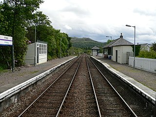
Morar railway station is a railway station serving the village of Morar in the Highland region of Scotland. This station is on the West Highland Line, between Arisaig and Mallaig, 36 miles 59 chains (59.1 km) from the former Banavie Junction, near Fort William. ScotRail, who manage the station, operate all the services here.

<span class="mw-page-title-main">Mallaig railway station</span> Railway station in the Scottish Highlands

Mallaig railway station is a railway station serving the ferry port of Mallaig, Lochaber, in the Highland region of Scotland. This station is a terminus on the West Highland Line, 41 miles (66 km) by rail from Fort William and 164 miles (264 km) from Glasgow Queen Street. The station building is Category C listed. ScotRail, who manage the station, operate most of the services.

<span class="mw-page-title-main">West Highland Railway</span> Former railway company in Scotland

The West Highland Railway was a railway company that constructed a railway line from Craigendoran to Fort William and Mallaig. The line was built through remote and difficult terrain in two stages: the section from Craigendoran to Fort William opened in 1894, with a short extension to Banavie on the Caledonian Canal opening in 1895.

"The Road to the Isles" is a famous tune composed by Pipe Major John McLellan DCM which was originally called ‘The Bens of Jura’, though it previously had other titles. It is part of the Kennedy-Fraser collection and it appeared in a book entitled 'Songs of the Hebrides' published in 1917, with the eponymous title by the Celtic poet Kenneth Macleod. The poem is headed by the statement 'Written for the lads in France during the Great War'. The impression is given by the notes appended to the book that the author was Kenneth Macleod himself. Marjory Kennedy-Fraser toured the Western Isles of Scotland in the summer of 1917 and collected a group of local tunes. The tune associated with the Road to the Isles was an air played by Malcolm Johnson of Barra on a chanter and composed by Pipe Major John McLellan of Dunoon. Kenneth Macleod then wrote the words for a voice and harp arrangement of this air by Patuffa Kennedy-Fraser.

<span class="mw-page-title-main">Lech-a-Vuie Platform railway station</span> Former railway station in Scotland

Lech-a-Vuie Platform railway station, Lechavuie or Lech-a-Vute was not constructed for public use. It stood close to the A830 road to the east of Loch Eilt near the Allt-a-Ghiughais burn and below Doire Dhamh on the West Highland Railway's extension to Mallaig. It stood in between the still extant Glenfinnan and Lochailort stations. At first it only served the needs of shooting parties on the Inverailort Estate owned by the Common-Head family, however it was later used by the army and navy during WWII and closed in the 1970s. Lech-a-vuie was 18.5 miles (30 km) from Mallaig Junction and stood at the summit of the line at a height of 379 feet.

References

  1. 1 2 Mallaig & Glenfinnan (inc. Loch Shiel) (Map). 1:50 000. Landranger. Ordnance Survey. 2015. 40.
  2. 1 2 Ben Nevis (inc. Fort William & Glen Coe) (Map). 1:50 000. Landranger. Ordnance Survey. 2015. 41.
  3. Murphy, Alan (2014). Scotland Highlands & Islands Footprint Handbook. Footprint. p. 221. ISBN   978-1-909-26862-3.
  4. "Opening up the road to the isles". The Scotsman. 7 March 2007. Retrieved 29 August 2017.
  5. "Road Facilities, West Coast of Scotland". Hansard. 22 March 1939. Retrieved 29 August 2017.
  6. "Fort William—Mallaig Road". Hansard. 10 February 1954. Retrieved 29 August 2017.
  7. "Fort William-Mallaig Road (Dual Carriageway)". Hansard. 17 November 1965. Retrieved 29 August 2017.
  8. Mabon, Dickson (19 November 1969). "A830, Fort William-Mallaig". Hansard. Retrieved 29 August 2017.
  9. "Mallaig Line (Closure)". Hansard. 1 March 1967. Retrieved 29 August 2017.
  10. 1 2 "Delight as infamous single-track A830 bites the dust". Scottish Herald. 11 April 2009. Retrieved 29 August 2017.
  11. Webster, Ben (3 December 2007). "Star-rating system shows which roads are most likely to kill you" . The Times. London, England. p. 4. Retrieved 29 August 2017.
  12. "LIST OF PUBLIC ROADS – PROPOSED REVISIONS" (PDF). The Highland Council. 12 June 2006. Archived from the original (PDF) on 27 September 2013. Retrieved 23 September 2013.
  13. "Countryfile - 25/05/2008". OnTelly. Retrieved 28 September 2022.
  14. "Lyrics – The 8-3-0". www.the-mccalmans.com.

Coordinates: 56°52′42″N5°29′13″W / 56.87842°N 5.48682°W / 56.87842; -5.48682