
Fort William is a town in Lochaber in the Scottish Highlands, located on the eastern shore of Loch Linnhe. At the 2011 census, Fort William had a population of 10,459, making it the second largest settlement in both the Highland council area, and the whole of the Scottish Highlands; only the city of Inverness has a larger population.

Loch is a word meaning "lake" or "sea inlet" in Scottish and Irish Gaelic, subsequently borrowed into English. In Irish contexts, it often appears in the anglicized form "lough".
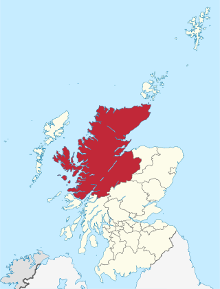
Highland is a council area in the Scottish Highlands and is the largest local government area in the United Kingdom. It was the 7th most populous council area in Scotland at the 2011 census. It shares borders with the council areas of Aberdeenshire, Argyll and Bute, Moray and Perth and Kinross. Their councils, and those of Angus and Stirling, also have areas of the Scottish Highlands within their administrative boundaries.

The Blackwater Reservoir is a reservoir created behind a dam in the mountains above Kinlochleven, Lochaber, Highland, Scotland. The dam is 914 metres (2,999 ft) long, the longest in the Highlands.
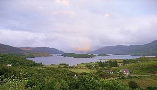
Loch Morar is a freshwater loch in Lochaber, Highland, Scotland. It is the fifth-largest loch by surface area in Scotland, at 26.7 km2 (10.3 sq mi), and the deepest freshwater body in the British Isles with a maximum depth of 310 m (1,017 ft). The loch was created by glacial action around 10,000 years ago, and has a surface elevation of 9 metres (30 ft) above sea level. It separates the traditional district of North Morar, from Arisaig and Moidart.

Loch Garry is a freshwater loch 25 km north of Fort William, Lochaber, Scotland. Loch Garry is 11 km long and 50 m deep. It is fed by waters from Loch Quoich 10 km upstream on the River Garry, and drains into Loch Oich in the Great Glen just 5 km downstream. Loch Garry is much photographed from the A87 for its romantic setting and also because a quirk of perspective makes it appear like a map of Scotland.
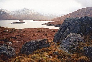
Loch Quoich is a loch and reservoir situated west of Loch Garry approximately 40 km northwest of Fort William, Lochaber, Scotland. The name means "loch of the quaich". In 1896, it was listed as six miles long and three-quarters of a mile in width, belonging to Mrs. Ellice of Glenquoich, within the parish of Kilmonivaig.

Loch Tummel is a long, narrow loch, seven kilometres northwest of Pitlochry in the council area of Perth and Kinross, Scotland. It is fed and drained by the River Tummel, which flows into the River Tay about 13 km (8 mi) south-east of the Clunie Dam at the loch's eastern end.
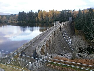
Laggan Dam is a dam located on the River Spean south west of Loch Laggan in the Scottish Highlands.

Loch Laggan is a freshwater loch situated approximately 6+1⁄2 mi (10.5 km) west of Dalwhinnie in the Scottish Highlands. The loch has an irregular shape, runs nearly northeast to southwest and is approximately 7 mi (11 km) in length. It has an average depth of 68 ft (21 m) and is 174 ft (53 m) at its deepest. The eastern end of the loch features the largest freshwater beach in Britain. Since 1934 Loch Laggan has been part of the Lochaber hydro-electric scheme. At the northeast end of the loch is the hamlet of Kinloch Laggan.

The Lochaber Narrow Gauge Railway was a 3 ft narrow-gauge industrial railway. It was a relatively long line, built for the construction and subsequent maintenance of a 15-mile-long (24-kilometre) tunnel from Loch Treig to a factory near Fort William in Scotland. The tunnel was excavated to carry water for the Lochaber hydroelectric scheme in connection with aluminium production by British Aluminium. The railway came to be known colloquially as the 'Old Puggy Line'.
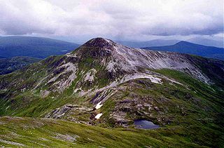
Stob Bàn is a mountain situated in the Lochaber region of Highland, Scotland, 16 kilometres east of Fort William. It reaches a height of 977 metres (3205 feet) and lies in a group of hills known as the Grey Corries which includes three other Munros and nine Munro "Tops" along an eight kilometre ridge. The mountain's name translate as “White Peak”, while other sources give the translation as Light Coloured Peak with the hill being covered in light coloured schist scree, in contrast to the rest of the Grey Corries which are made up of grey quartzite scree. The mountain is a prominent conical shape, isolated from the rest of the group and distant from any main roads. It should not be confused with another Munro named Stob Bàn situated in the Mamores.

Chno Dearg is a mountain in the Lochaber area of the Scottish Highlands. It overlooks Glen Spean to the north and Loch Treig to the west. With a height of 1,046 metres (3,432 ft), it is classed as a Munro.

Stob a' Choire Mheadhoin is a mountain in the Scottish Highlands, it is situated 19 km east of Fort William in the Lochaber area of the Highland council area.

Fersit is a hamlet close to Tulloch railway station in Lochaber, Scottish Highlands and is in the Highland council area.
The Lochaber hydroelectric scheme is a hydroelectric power generation project constructed in the Lochaber area of the western Scottish Highlands after the First World War. Like its predecessor at Kinlochleven, it was intended to provide electricity for aluminium production, this time at Fort William, a little further north. It is still in operation.

The River Nevis flows from the mountains east of Ben Nevis to its mouth near the town of Fort William in Scotland.

The River Spean flows from Loch Laggan in a westerly direction to join the River Lochy at Gairlochy in the Great Glen in the West Highlands of Scotland. Major tributaries of the Spean include the left-bank Abhainn Ghuilbinn and River Treig, the right-bank River Roy and the left-bank river known as The Cour. The river is accompanied by the A86 road for almost its entire length, running from (upper) Loch Laggan west to Spean Bridge. The river is spanned by a bridge carrying the A82 road near its junction with the A86 at Spean Bridge. A minor road bridges the Spean just above the falls at Inverlair. Two further road crossings exist - a private estate road across the short stretch of river between upper Loch Laggan and the Laggan reservoir and a road traversing the top of Laggan Dam. The West Highland Line crosses the river near Tulloch Station and follows its north bank before re-crossing one mile east of Spean Bridge. A branch of the railway formerly continued west beside the river from Spean Bridge, crossing it once again to the west of the village.
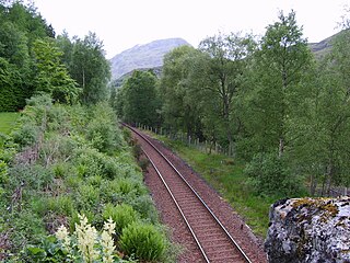
Fersit Halt railway station named after the nearby hamlet of Fersit, was situated close to Tulloch railway station in Lochaber, Highland council area, Scotland. Fersit was a remote rural temporary private halt at the north end of Loch Treig where workers were housed who worked on the Lochaber hydroelectric scheme. The halt was opened in 1931 by the LNER, it was located near the site of a contractors railway ballast siding.

