Loch Laggan

Last updated

Loch Laggan
Loch Laggan Ecosse.jpg
Highland UK relief location map.jpg
Red pog.svg
Loch Laggan
Location Inverness-shire, Highland, Scotland
Coordinates 56°56′53″N4°29′24″W / 56.9481°N 4.4901°W / 56.9481; -4.4901 Coordinates: 56°56′53″N4°29′24″W / 56.9481°N 4.4901°W / 56.9481; -4.4901 [1]
Type freshwater loch
Primary inflows River Pattack [2]
Primary outflows River Spean [2]
Basin  countries Scotland
Max. length7 mi (11 km) [2]
Max. width0.66 mi (1.06 km) [2]
Surface area216.5 ha (535 acres) [1]
Average depth68 ft (21 m) [2]
Max. depth174 ft (53 m) [2]
Water volume5,600,000,000 cu ft (160,000,000 m3) [2]
Surface elevation248 m (814 ft) [1]
Islands 9 [1]

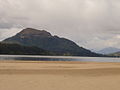
Loch Laggan is a freshwater loch situated approximately 6+12 mi (10.5 km) west of Dalwhinnie in the Scottish Highlands. The loch has an irregular shape, runs nearly northeast to southwest and is approximately 7 mi (11 km) in length. It has an average depth of 68 ft (21 m) and is 174 ft (53 m) at its deepest. The eastern end of the loch features the largest freshwater beach in Britain. Since 1934 Loch Laggan has been part of the Lochaber hydro-electric scheme. At the northeast end of the loch is the hamlet of Kinloch Laggan.

Contents

The loch was surveyed [2] on 2 and 3 of June 1902 by Sir John Murray, T.R.N. Johnston, James Parsons and James Murray and was later charted [3] as part of the Bathymetrical Survey of Fresh-Water Lochs of Scotland 1897-1909.

The A86 road from Spean Bridge to Kingussie follows the loch's north shore. The River Pattack flows into the head of the loch just below the road bridge at Kinloch Laggan. The boundary of the Cairngorms National Park wraps around the head of the loch. A short section of the River Spean connects the natural loch with the reservoir downstream and this river continues westwards below Laggan Dam. Two other substantial watercourses empty into the loch, the Allt Labhrach which drains Lochan na h-Earba which lies southeast of Loch Laggan and Allt Coire Ardair which rises beneath Creag Meagaidh. The remains of an island dwelling lie in the middle of the loch near Ardverikie. [4]

The loch featured in the popular BBC series Monarch of the Glen as Loch Bogle.

Loch Laggan (mostly its castle) is featured in the Temeraire series of novels, being used as a base to raise dragons, because of geothermal heat sources.

Some scenes for Monarch of the Glen were filmed on the shores of the loch. [5]

During summer 2019, filming for No Time to Die was taking place in and near the Cairngorms National Park. [6] Some scenes were also being shot at the Ardverikie House Estate and on the banks of Loch Laggan. [7]

The Loch lends its name to The Laggan, a Scottish folk band, active in the 1960s and 70s who released a series of records and performed internationally. [8] [9]

See also

Related Research Articles

Perthshire Historic administrative division in Scotland

Perthshire, officially the County of Perth, is a historic county and registration county in central Scotland. Geographically it extends from Strathmore in the east, to the Pass of Drumochter in the north, Rannoch Moor and Ben Lui in the west, and Aberfoyle in the south; it borders the counties of Inverness-shire and Aberdeenshire to the north, Angus to the east, Fife, Kinross-shire, Clackmannanshire, Stirlingshire and Dunbartonshire to the south and Argyllshire to the west. It was a local government county from 1890 to 1930.

Cairngorms National Park National park in Scotland

Cairngorms National Park is a national park in northeast Scotland, established in 2003. It was the second of two national parks established by the Scottish Parliament, after Loch Lomond and The Trossachs National Park, which was set up in 2002. The park covers the Cairngorms range of mountains, and surrounding hills. Already the largest national park in the United Kingdom, in 2010 it was expanded into Perth and Kinross.

Loch Ericht Loch in the Highlands of Scotland

Loch Ericht is a freshwater loch on the border between the former Perthshire, now Perth and Kinross and the former Inverness-shire, now Highlands Council areas of Scotland. It has a north-east to south-west orientation. The village of Dalwhinnie lies at the north east end of the loch. Loch Ericht is the tenth largest freshwater lake in Scotland and has a good reputation for its trout fishing and Ferox trout.

Loch Oich

Loch Oich is a freshwater loch in the Highlands of Scotland which forms part of the Caledonian Canal, of which it is the highest point. This narrow loch lies between Loch Ness and Loch Lochy in the Great Glen. It is fed by the River Garry from the west, and feeds the River Oich from its northern end. The Laggan locks separate it from Loch Lochy.

Laggan is the name of numerous places in Scotland, including:

Loch Scaven

Loch Scaven is a small freshwater loch at the head of Glen Carron near the source of the River Carron, Wester Ross, Scotland. It is about 4 mi (6.4 km) southwest of Achnasheen and 2 mi (3.2 km) from Loch Gowan. The loch tends in a northeast to southwest direction and its shore is relatively simple. At the west end there is a significant promontory known as 'Cnoc nan Sguad' which projects into the loch on the northern shore. There are two small islands in the centre of the loch opposite Cnoc nan Sguad.

Loch an Eilein is a small irregular shaped, freshwater loch in the Rothiemurchus Forest about 5 km (3.1 mi) south of Aviemore, Scotland in Cairngorms National Park. Loch an Eilein comes from the Scottish Gaelic and means 'Loch of the island'. The loch is considered to be beautiful and walks around it are popular.

Loch Muick

Loch Muick is an upland, freshwater loch lying approximately 5 mi (8.0 km) south of Braemar, Scotland at the head of Glen Muick and within the boundary of the Balmoral estate.

Beinn a Chaorainn (Glen Spean) Scottish mountain in the Lochaber region of the Highland Council area

Beinn a' Chaorainn is a Scottish mountain situated on the northern side of Glen Spean in the Lochaber region of the Highland Council area. The mountain which is located 30 km east-northeast of Fort William is one of several of the same name in the Scottish Highlands and should not be confused with another well known Beinn a' Chaorainn in the Cairngorms.

East Highland Way

The East Highland Way is a long distance walking route in Scotland that connects Fort William (56.8178°N 5.1109°W) with the ski and mountain resort of Aviemore (57.1899°N 3.8292°W). The route was described by Kevin Langan in 2007. The name is derived from the fact that the route terminates in Aviemore at the eastern edge of Highland region. The EHW route takes in a varied and wild landscape through deep forest plantations, passing many highland lochs and negotiating unspoilt marshlands. The route also explores the ancient Caledonian forests of Inshriach. The walk is 82 miles (132 km) long.

Loch Màma

Loch Màma is a small freshwater loch in South Morar, Lochaber, in the north west of Scotland. It forms a simple basin and is orientated east to west. It is thought that the adjoining loch Loch na Creige Duibhe and Loch Màma were at one time a single loch. Debris brought down by the Allt Dearg stream has likely caused the lochs to be separated into two bodies of water. The loch is the source of the river Allt a' Mhama.

Loch na Creige Duibhe (Lochaber) Freshwater lake in Scotland

Loch na Creige Duibhe is a small freshwater loch in South Morar, Lochaber, in the West Highlands of Scotland. It is orientated east to west and drains into Loch Màma to the west. It is thought that Loch Màma and Loch na Creige Duibhe were at one time a single loch. Debris brought down by the Allt Dearg stream has likely caused the lochs to be separated into two bodies of water.

Loch Callater

Loch Callater is an upland, freshwater loch lying approximately 5 miles (8 km) south of Braemar, Scotland. The loch trends in a northwest to southeast direction and is surrounded on both sides by steep hills. It is approximately 1.6 km (1 mi) in length.

Ardverikie House

Ardverikie House is a 19th-century Scottish baronial house in Kinloch Laggan, Newtonmore, Inverness-shire, Scottish Highlands. The house was made famous as the fictional Glenbogle estate in the BBC series Monarch of the Glen.

River Spean River in the West Highlands of Scotland

The River Spean flows from Loch Laggan in a westerly direction to join the River Lochy at Gairlochy in the Great Glen in the West Highlands of Scotland. Major tributaries of the Spean include the left-bank Abhainn Ghuilbinn and River Treig, the right-bank River Roy and the left-bank river known as The Cour. The river is accompanied by the A86 road for almost its entire length, running from (upper) Loch Laggan west to Spean Bridge. The river is spanned by a bridge carrying the A82 road near its junction with the A86 at Spean Bridge. A minor road bridges the Spean just above the falls at Inverlair. Two further road crossings exist - a private estate road across the short stretch of river between upper Loch Laggan and the Laggan reservoir and a road traversing the top of Laggan Dam. The West Highland Line crosses the river near Tulloch Station and follows its north bank before re-crossing one mile east of Spean Bridge. A branch of the railway formerly continued west beside the river from Spean Bridge, crossing it once again to the west of the village.

Loch Eigheach

Loch Eigheach is a large upland dammed freshwater loch in the Scottish Highlands. It is located in Rannoch Moor in the Council Area of Perth and Kinross. The undisturbed Loch Eigheach was much smaller.

Binnein Shuas

Binnein Shuas is a mountain in the Grampian Mountains of Scotland. It lies between Loch Laggan and Lochan na h-Earba in Inverness-shire.

Loch Turret A lake in Perth and Kinross, Scotland

Loch Turret is a large freshwater reservoir on a north-east to south-west orientation, that is located at the head of Glen Turret and 5.39 miles (8.67 km) northwest of Crieff in Perth and Kinross.

Lochan na h-Earba

The single name Lochan na h-Earba is applied to two lochs to the south of Loch Laggan in Highland, Scotland, close to the historic boundary between Lochaber and Badenoch. It is thought that the two lochs once formed a single loch, but became separated by the build up alluvial deposits from the Moy Burn, which now joins the short watercourse that connects the two lochs. Ordnance Survey maps of the area show a single name printed across both lochs. They occupy a narrow glen running southwest to northeast, and roughly parallel with Loch Laggan, from which they are separated by the Binnein Shuas range of hills. The Munros of Geal Charn and Creag Pitridh are the highest peaks of the hills to the southeast.

References

  1. 1 2 3 4 "Loch Laggan". British lakes. British Lakes. Retrieved 12 June 2016.
  2. 1 2 3 4 5 6 7 8 "Bathymetrical Survey of the Fresh-Water Lochs of Scotland, 1897-1909, Lochs of the Lochy Basin". National Library of Scotland . Retrieved 12 June 2016.
  3. "Loch Laggan and Lochan na H-Earba (Vol. 4, Plate 85), Bathymetrical Survey, 1897-1909". National Library of Scotland . Retrieved 12 June 2016.
  4. Ordnance Survey 1:25,000 scale mapping
  5. http://www.newtonmore.com/things-to-do/immediate-vicinity/monarch-of-the-glen.html, Monarch of the Glen
  6. https://www.bbc.co.uk/news/amp/uk-scotland-highlands-islands-48989212, New Bond movie scenes being filmed in Highlands
  7. https://www.thecourier.co.uk/fp/news/scotland/936418/james-bond-25-car-chase-filmed-and-accommodation-set-up-as-filming-begins-in-scotland/, James Bond 25: ‘Car chase’ filmed and accommodation set up as production begins in Scotland
  8. "Arthur Johnstone". 26 September 2017.
  9. "Scottish Folk Groups - The Laggan".