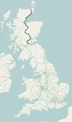
The A9 is a major road in Scotland running from the Falkirk council area in central Scotland to Scrabster Harbour, Thurso in the far north, via Stirling, Bridge of Allan, Perth and Inverness. At 273 mi (439 km), it is the longest road in Scotland and the fifth-longest A-road in the United Kingdom. Historically it was the main road between Edinburgh and John o' Groats, and has been called the spine of Scotland. It is one of the three major north–south trunk routes linking the Central Belt to the Highlands - the others being the A82 and the A90.

The M9 is a major motorway in Scotland. It runs from the outskirts of Edinburgh, bypassing the towns of Linlithgow, Falkirk, Grangemouth and Stirling to end at Dunblane.

The M90 is a motorway in Scotland. It runs from Junction 1A of the M9 motorway, south of the Queensferry Crossing, to Perth. It is the northernmost motorway in the United Kingdom. The northern point goes to the western suburbs of Perth at Broxden. A small part of the M90 was originally numbered as the M85 motorway.

The Stirling council area is one of the 32 council areas of Scotland, and has a population of about 93,470. It was created in 1975 as a lower-tier district within the Central region. The district covered parts of the historic counties of Stirlingshire and Perthshire, which were abolished for local government purposes. In 1996 the Central region was abolished and Stirling Council took over all local government functions within the area.

The M80 is a motorway in Scotland's central belt, running between Glasgow and Stirling via Cumbernauld and Denny and linking the M8, M73 and M9 motorways. Following completion in 2011, the motorway is 25 miles (40 km) long. Despite being only a two lane motorway, parts of the M80 Stepps Bypass are used by around 60,000 vehicles per day.

The Edinburgh City Bypass, designated as A720, is one of the most important trunk roads in Scotland. Circling around the south of Edinburgh, as the equivalent of a ring road for the coastal city, it links together the A1 towards north-east England, the A702 towards north-west England, the M8 through the Central Belt towards Glasgow, the A7 through south-east Scotland and north-west England as well as the A8 leading to the M9 for Stirling and the Queensferry Crossing.
The M876 motorway is a motorway in Scotland. The motorway runs from Denny to Airth in the Falkirk council area, forming an approach road to the Kincardine Bridge. It was opened in 1980.

The A417 is a main road in England running from Streatley, Berkshire to Hope under Dinmore, Herefordshire. It is best known for its section between Cirencester and Gloucester where it has primary status and forms part of the link between the major settlements of Swindon and Gloucester.

Broxden Junction is one of the busier and more important road junctions in Scotland. It is located on the outskirts of Perth, and is one of the city's two major roundabouts – the other being Inveralmond Roundabout, where the A9 meets the A912 Dunkeld Road, 2.3 miles (3.7 km) to the north-northwest. The roundabout, oval in shape, is an important hub of the Scottish road network, a major junction on the A9 north–south route, and the UK's northernmost motorway junction, being junction 12 of the M90 motorway. Prior to Dunfermline's ascension to city status, all of the seven cities in Scotland were signposted from its exits.

Kippen is a village in west Stirlingshire, Scotland. It lies between the Gargunnock Hills and the Fintry Hills and overlooks the Carse of Forth to the north. The village is 9 miles west of Stirling and 20 mi (32 km) north of Glasgow. It is 4+1⁄2 mi (7 km) south-east of Loch Lomond and the Trossachs National Park, Scotland's first National Park.
The B800 is a short road in eastern Scotland, connecting the Forth Road Bridge to Kirkliston. It is a two-way single carriageway road.
Buchlyvie is a village in the Stirling council area of Scotland. It is situated 14 miles (23 km) west of Stirling and 18 miles (29 km) north of Glasgow. Lying within the Carse of Forth, to the north is Flanders Moss and to the south are the Campsie Fells. The village lies on the A811, which follows the line of an eighteenth-century military road between Stirling and Balloch. According to the 2001 census the village's population was 479.

Newbridge is a village within the parish of Kirkliston, to the west of Edinburgh, Scotland. It originally lay on the western edge of the county of Midlothian; however, local government reforms in the late 20th century placed it within the City of Edinburgh council area.
The A912 is a major road in both Perth and Kinross and Fife, Scotland. It runs from the A9 in Perth, in the north, to the A92 at Muirhead, in the south. Part of it was formerly part of the A90.

The A725 road in Scotland is a major route which is a trunk road dual carriageway for almost its whole length, connecting several of the large towns of North Lanarkshire and South Lanarkshire, linking the M8 and M74 motorways; it has been upgraded frequently since its construction, with the most recent major work completed in 2017. In combination with the A726 road which meets the M77 motorway, it forms a southern and eastern bypass for the city of Glasgow.
The A89 is a trunk road in Scotland, United Kingdom. It runs from High Street, Glasgow to Newbridge in Edinburgh. It was once the A8, which has now been replaced, mostly by the M8.

Lecropt is a rural parish lying to the west of Bridge of Allan, Scotland.

Arnprior is a hamlet in the Stirling council area of Scotland on the A811 about 12 miles west of Stirling and is one of the smallest community council districts in the region. The hamlet is next to the Flanders Moss National Nature Reserve and close to the east boundary of the Loch Lomond and Trossachs National Park, which includes the Lake of Menteith.

Port of Menteith is a village and civil parish in the Stirling district of Scotland, the only significant settlement on the Lake of Menteith. It was established as a burgh of barony, then named simply Port, in 1457 by King James III of Scotland. It lies in the historic county and Registration County of Perthshire.
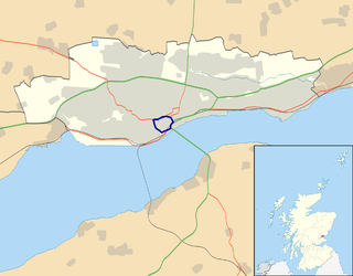
The A991 is a major road in Dundee, Scotland. It forms the Inner Ringroad that circles the perimeter of Dundee's city centre.

