
 | |
|---|---|
| Route information | |
| Length | 14.7 mi [1] (23.7 km) |
| Major junctions | |
| North end | Bridgend 55°46′55″N6°14′56″W / 55.7819°N 6.249°W |
| A846 | |
| South end | Portnahaven 55°40′51″N6°30′23″W / 55.6808°N 6.5063°W |
| Location | |
| Country | United Kingdom |
| Constituent country | Scotland |
| Road network | |
The A847 road is one of the two principal roads of Islay in the Inner Hebrides off the west coast of mainland Scotland.
Contents
It connects Bridgend, at a junction with the A846 road, with Portnahaven at the southern end of the Rinns of Islay peninsula. It is some 14+1⁄2 miles (23 km) long.
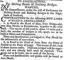
The road was completed in 1806 following the route surveyed by John Langlands of Campbeltown. [2]