Inver Hydro-Electric Scheme is a remote hydro-electric plant on the Scottish island of Jura, part of the Inner Hebrides. Construction began in 2011, and it was operational by June 2012. It is the third scheme built on the Inver Estate, but the first to be connected to the National Grid. It can produce 2MW of electric power.
During the winter of 2019/2020, it ran at capacity for over three months, when a fault developed on the undersea cable that connects Jura to the mainland, and supplies the islands of Islay and Colonsay. The scheme was used as part of a constraint management zone, using renewable energy rather than diesel generators to maintain supplies to the three islands. The emergency lasted from 20 November 2019 until late Match 2020, when calmer weather allowed a new cable to be laid across the Sound of Jura. During this period, the station produced some 5GWh of energy.
History
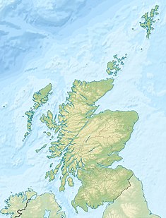
The Inver Estate lies on the west coast of Jura, to the north of the Feolin ferry slipway. Inver Cottage lies around 1.2 miles (1.9km) to the north of the slipway.[1] The cottage was first supplied with electricity in the 1960s, when a waterwheel was installed nearby, to drive a direct-current generator. This scheme lasted until the early 1980s, when it was replaced by a small hydro-electric plant, rated at 30kW. This had sufficient capacity to power Feolin Ferry House and streetlights close to the ferry slipway.[2] The slipway is a category B listed structure, and was originally built around 1810. Thomas Telford managed the project, acting for the Parliamentary Commissioners for Highland Roads and Bridges, while James Hollingworth was the engineer.[3] The Ferry House is also listed[4] and is attributed to Telford.[2]
The generator gave good service for over 30 years, but there was a need for additional energy, and the decision was taken to install a much larger hydro-electric system, and connect it to the National Grid, so that spare power could be exported.[5] The site of the scheme is environmentally sensitive, as it is located within the Jura National Scenic Area, and Optimised Environments were commissioned to make a landscape and visual assessment for the scheme. Planning permission was obtained in July 2010, but the details were altered, and a second assessment to account for the changes was produced in December 2010. Construction work began in the spring of 2011.[6]
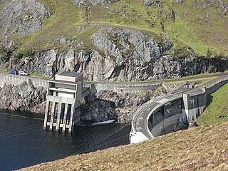
The storage reservoir for the scheme was created by constructing a dam across the outlet of Lochan Gleann Astaile, on the southern slopes of the Paps of Jura, to raise the level of the loch by 10 feet (3m). The dam is 920 feet (280m) long and impounds some 700 megalitres (Ml) of water. From the dam, 2,700 yards (2,500m) of underground pipeline carry the water to the turbines. The polyethylene pipe is 47 inches (1,200mm) in diameter, and is suitable for the static head of 430 feet (130m) created by the drop in level from the dam to the turbines. The whole system is designed to last at least 50 years with minimal maintenance.[5]
In common with most of the schemes developed by the North of Scotland Hydro-Electric Board in the 1950s and 1960s, the catchment of the reservoir was increased by capturing the headwaters of three other streams. The Southern Ditch intercepts the Abhainn Gleann Iubharnadail, on the border of the Inver and Ardfin estates. A short underground section is followed by an open aqueduct, which is crossed by two pedestrian bridges and four bridges suitable for all-terrain vehicles. The Northern Ditch runs from the Allt an t-Sluic Bhrodaich, and also consists of a short underground section and a long open aqueduct, which is crossed by three pedestrian bridges and two all-terrain vehicle bridges. The Northern Ditch Extension joins the Northern Ditch, carrying water from the Allt Blar Buidhe an t-Sluic Bhrodaich.[2] Concrete weirs were constructed at each of the intake points, to direct water into the ditches.[5] Below the intake points, the two northern rivers combine to form the Allt Bun an Eas, before discharging into the Sound of Islay.[1]
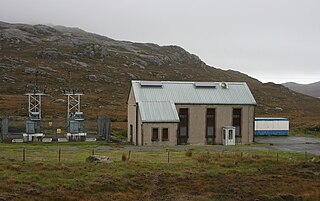
The scheme was developed by a partnership between Inver Farmers and Lithgows, the Glasgow shipbuilders, with generation of electricity beginning in June 2012,[7] although work continued on the project until December.[2] The powerhouse from the 1980s scheme was relocated next to the new powerhouse, and is operated during periods of low rainfall.[5] The new building contains two Francis turbines, rated at 1MW each,[8] and the reservoir stores enough water to power the turbines for ten days.[2]
Electricity connection
Jura is connected to the National Grid by a transmission line from Lochgilphead which runs to Tayvallich and then crosses the Sound of Jura by an undersea cable. On Jura, the transmission line continues down the east coast and along the southern coast. Another undersea cable runs from just north of the tiny island of Glas Eilean on Jura to Traigh Bhan on Islay. A third undersea cable runs from the north-east corner of Islay near the Ruvaal Lighthouse to supply the island of Colonsay.[9] In order to benefit from the feed-in tariffs available to producers of green energy,[8] over 4 miles (6.4km) of 33kV underground cable were used to connect the turbines to the grid near Ardfin, with surplus energy being sold to the grid.[2]
Operation
The turbines are housed in an unremarkable building, while the 1980s scheme turbine house is located behind this structure.
On 20 November 2019, a fault occurred on the undersea cable from Tayvallich to Jura, and Scottish and Southern Electricity Networks (SSEN) implemented a constraint management zone to ensure the consumers on Jura, Islay and Colonsay continued to have an electricity supply.[9] Constraint management zones are a method of managing faults and power outages by the use of renewable resources, rather than resorting to temporary diesel generators. Inver hydro-electric scheme was a major part of this, running at full capacity for several months, and producing around 40 per cent of the total requirements for all three islands. The remainder was generated by black starting Bowmore diesel power station on Islay. The Inver scheme supplied 5GWh of energy over a four-month period, saving customers around £230,000, compared with using diesel generators, and avoiding the production of some 2,450 tonnes of carbon dioxide, which they would have produced.[10]
The Bowmore station was originally built by the Royal Air Force after the Second World War, and was acquired by the North of Scotland Hydro-Electric Board in 1949. It was expanded, and now has a capacity of 6MW, but since the National Grid reached the islands in 1962, it has only been used as a backup.[11]
SSEN decided to replace the entire undersea cable, and received a marine licence allowing them to proceed on 24 January 2020. A cable laying ship arrived in the Sound of Jura soon afterwards, but severe weather conditions prevented it from laying the cable.[12] The weather also caused a number of faults to the electricity network on the islands, causing the power station to trip out on several occasions. The ship remained in the area, and calmer weather finally came in late March. The cable was laid on 25 March, and the connection to the National Grid was reinstated on 31 March.[9]
Since 2017, Inver Hydro have been in dispute with the rating authority over the level of business rates charged. When the business was set up in 2010, rates were £104,000 per year. Despite the fact that the basis on which such rates are calculated has not changed, they were increased to £264,000 in 2017, and to £565,000 in 2023. Such increases have been applied to many of the smaller hydro-electric schemes in Scotland, although some have seen a similar level of reduction, with the rates for one scheme dropping from £74,000 to just £14,000. The rates for the Inver scheme are now more than those for two neighbouring wind farms combined, which between them can generate 16MW. The company appealed against the increase in 2017, and are one of over 200 similar businesses that had outstanding appeals in 2022.[13][14]
Hydrology
The reservoir for the scheme is Lochan Gleann Astaile. This has a surface area of 52 acres (21ha), the surface is 440 feet (134m) above ordnance datum (AOD), and its catchment area is 3.48 square miles (9.01km2).[15] It is fed by the Abhainn Gleann Astaile and a network of tributaries which drain the southern foothills of the Paps of Jura. The Abhainn Gleann Iubharnadail drains the slopes of two smaller hills, the Glas Bheinn and Dubh Bheinn. A weir just above a waterfall supplies the Southern Ditch. The Allt an t-Sluic Bhrodaich, which feeds the Northern Ditch, drains three small lochs located on a saddle between two of the Paps, Bheinn a' Chaolais to the south and Bheinn an Oir to the north. The Allt Blar Buidhe an t-Sluic Bhrodaich, which feeds the Northern Ditch Extension, drains the western foothills of Bheinn an Oir.[1]
A small amount of compensation water is released from the dam to feed the Abhainn a' Chnuic Bhric, which flows to the northwest and empties into Loch a' Chnuic Bhric.[1] This has a surface area of 64 acres (26ha), is located at 52 feet (16m) AOD, and drains a catchment of 5.27 square miles (13.65km2).[16] From its outlet, the Abhainn na h-Uanaire flows southwards, parallel to the coast, and its flow is swelled by the tailrace from the hydro-electric station just before it flows into the Abhainn Gleann Iubharnadail. Below the confluence are two weirs. A conduit from the first weir runs parallel to the river, and probably drove the 1960s waterwheel. The river is tidal below the second weir, and enters the Sound of Islay soon afterwards.[1]
Related Research Articles
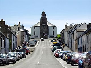
Bowmore is a small town on the Scottish island of Islay. It serves as administrative capital of the island, and gives its name to the noted Bowmore distillery producing Bowmore single malt scotch whisky.
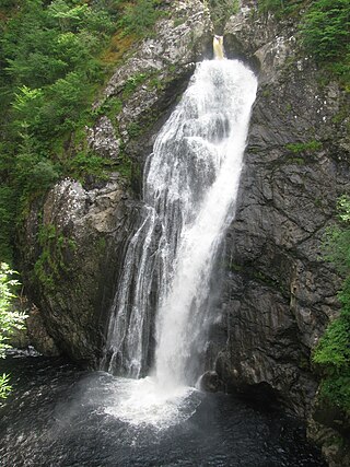
The Falls of Foyers are two waterfalls on the River Foyers, which feeds Loch Ness, in Highland, Scotland. They are located on the lower portion of the River Foyers, and consist of the upper falls, with a drop of 46 feet (14 m) and the lower falls, which drop 98 feet (30 m).
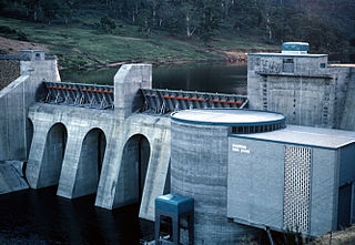
Guthega Power Station is located in the Snowy Mountains region of New South Wales, Australia. The power station's purpose is for the generation of electricity. It is the first to be completed and smallest of the initial seven hydroelectric power stations that comprise the Snowy Mountains Scheme, a vast hydroelectricity and irrigation complex constructed in south-east Australia between 1949 and 1974 and now run by Snowy Hydro.
The Meadowbank Power Station is a run-of-the-river hydroelectric power station located in the Central Highlands region of Tasmania, Australia. The power station is situated on the Lower River Derwent catchment and is owned and operated by Hydro Tasmania.
The Affric-Beauly hydro-electric power scheme for the generation of hydro-electric power is located in the western Highlands of Scotland. It is based around Glen Strathfarrar, Glen Cannich and Glen Affric, and Strathglass further downstream.
The River Add is a river which runs through Argyll and Bute on the west coast of Scotland. Historically, it was known as the river Airigh but to avoid confusion with the Aray, it was renamed the River Add.
Islay is the southernmost island of the Inner Hebrides of Scotland. Known as "The Queen of the Hebrides", it lies in Argyll just south west of Jura and around 40 kilometres north of the Northern Irish coast. The island's capital is Bowmore where the distinctive round Kilarrow Parish Church and a distillery are located. Port Ellen is the main port.
Nostie is a small remote hamlet, lying on Nostie Bay, an inlet at the northeastern end of the sea loch, Loch Alsh in the Scottish Highlands and is in the council area of Highland. Nostie lies a short distance from one of Scotland's popular tourist attractions, Eilean Donan Castle.
The Sound of Islay is a narrow strait between the islands of Islay and Jura off the west coast of Scotland. It is about 30 kilometres in extent from north to south and lies between Rubh' a' Mhàil on Islay and Rubh' Aird na Sgitheich on Jura to the north and Macarthur's Head and Rubha na Tràille to the south. The islands in the Sound are Am Fraoch Eilean, Brosdale Island and Glas Eilean, all of which are off the south east coast of Jura. These islands, Jura south of Loch Tarbert and the eastern part of the Sound are one of 40 National Scenic Areas in Scotland.
Shetland HVDC Connection is a high-voltage direct current submarine power cable under construction to connect Shetland to the British mainland.
The Lanark Hydro Electric Scheme consists of two hydroelectric plants in the Clydesdale area of South Lanarkshire, Scotland. They are run-of-the-river power stations, using water from the River Clyde near to the Falls of Clyde. Bonnington Power Station gets its water supply from just above Corra Linn in New Lanark, while Stonebyres Power Station takes water from above Stonebyres Linn near Kirkfieldbank. Bonnington is the larger of the two stations, which between them can produce 17 MW.
The Pupu Hydro Power Scheme is a small hydroelectric power station near Tākaka in the Golden Bay region of the South Island of New Zealand. It opened in 1929 as the first power station in the region and was the first public electricity supply in Golden Bay. After closing in 1980 following damage to the generator, the power scheme was fully restored by the local Pupu Hydro Society and many volunteer groups over the course of seven years and re-opened in 1988, again supplying electricity to the national grid.
Scottish and Southern Electricity Networks is one of two energy companies in the UK to be involved both in electricity transmission and distribution.
Linton Falls Hydro is a hydroelectric generating power station located on the Linton Falls Weir of the River Wharfe, near Grassington, North Yorkshire, England. The power station is located on the same site as a hydroelectric scheme that was first opened in 1909, but had closed by 1948. The new scheme, which opened in March 2012, uses the original building which is now a scheduled monument.
The Western Isles HVDC connection is a proposed 1.8GW HVDC submarine power cable to connect the Isle of Lewis to the Scottish mainland.
Eastern HVDC and Eastern HVDC projects are the names used by Ofgem for two planned HVDC submarine power cables from the East coast of Scotland to Northeast England to strengthen the National Grid. The two links combined will deliver 4GW of renewable energy from Scottish wind farms to England.
Chliostair Hydro-Electric Scheme is a small scheme promoted by the North of Scotland Hydro-Electric Board on Harris, Outer Hebrides. It consists of a single power station powered with water from Loch Chliostair, and was commissioned in 1960.
There are several hydro-electric schemes on the Isle of Arran, an island in the Firth of Clyde, Scotland. Most of them were installed during the early 21st century, but one is considerably older.
Lussa Hydro-Electric Scheme is a small-scale hydro-electric power station, built by the North of Scotland Hydro-Electric Board and commissioned in 1956. It is located near Peninver on the Kintyre peninsula, part of Argyll and Bute in Scotland. It was originally designed to supply power to Campbeltown, but is now connected to the National Grid.
Loch Gair Hydro-Electric Scheme is a small-scale hydro-electric power station, built by the North of Scotland Hydro-Electric Board and commissioned in 1956. It is located near Lochgair, a hamlet to the north-east of Lochgilphead, Argyll and Bute in Scotland. It was originally designed to supply power to Lochgilphead and the surrounding communities, but is now connected to the National Grid.
This page is based on this Wikipedia article Text is available under the CC BY-SA 4.0 license; additional terms may apply. Images, videos and audio are available under their respective licenses.