Related Research Articles

Baleshare is a flat tidal island in the Outer Hebrides of Scotland. Baleshare lies to the south-west of North Uist. Its economics and community were boosted by the building of a causeway in 1962. The 350-metre (380 yd) causeway was built by William Tawse Ltd. The island is extremely flat by Hebridean standards, rising to only 12 metres above sea level and known for its long sandy beach. It has a population of 49 living in two settlements: Samhla and Teananachar.

Findon or Finnan is a fishing village eight miles south of Aberdeen, famous for originating the smoked haddock known as Finnan haddie. The Findon moor has a number of paths through it, many of which run along the cliffs. Deer can often be seen there. Nearby features include the Portlethen Moss Nature Reserve.

The River Ugie or Ugie Water is a river in North East Scotland; it flows into the North Sea on the east coast at Peterhead, north of Cruden Bay. There is considerable evidence of prehistoric settlement within the Ugie drainage basin, especially in the South Ugie Water catchment basin. For example, the Catto Long Barrow is found somewhat to the south of the Ugie Water mainstem.

Deer Abbey was a Cistercian monastery in Buchan, Scotland. It was founded by 1219 AD with the patronage William Comyn, jure uxoris Earl of Buchan, who is also buried there. There was an earlier community of Scottish monks or priests, never numbering more than fifteen. The notitiae on the margins of the Book of Deer record grants made to the Scottish religious community in the 12th century and a claim that it was founded by Saint Columba and Saint Drostan. The old religious community was probably absorbed by the new foundation. The history of the abbey after the 1210s is obscure until the 16th century, when it was beginning to be secularized. The abbey was turned into a secular lordship for Commendator Robert Keith II in 1587.

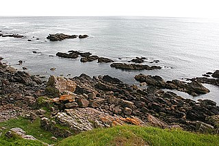
Portlethen Village is a settlement along the North Sea coast in Aberdeenshire, Scotland. The village is also known as Old Portlethen. The skerry of Craigmaroinn is situated just off the coastline near Portlethen Village.

Downies is a cliff-top village in Aberdeenshire, Scotland situated on Cammachmore Bay. Historically Downies was a fishing village, until much of the local North Sea fishery collapsed from overfishing; presently Downies is chiefly a residential dormitory adjunct to the city of Aberdeen.
Red Moss is a wetland bog in Aberdeenshire, Scotland, located at the northwestern edge of the village of Netherley. The moss is designated a national Site of Special Scientific Interest by Scottish Natural Heritage, due to its biodiversity and undisturbed character. The elevation of Red Moss is 113 metres above mean sea level. The upland areas above Red Moss are characterised as agricultural and woodland parcels which are generally attractive and separated by ancient drystone walls or hedgerows.
Eden Water is a tributary of the River Tweed in the Scottish Borders of Scotland. "Water" is the Lowland Scots term for a small river.

Bridge of Muchalls is an entirely residential hamlet in Aberdeenshire, Scotland by the North Sea. It is on the A90 dual carriageway about three miles north of Stonehaven and to the south of Muchalls Castle.
Curlethney Hill is a landform in Aberdeenshire, Scotland within the Mounth Range of the Grampian Mountains. The peak elevation of this mountain is 246 metres above mean sea level. This landform lies slightly southwest of the village of Netherley. The northwest boundary of the moorland atop Curlethney Hill is formed by the southwestern flanks of Craggie Cat, a nearby peak.
Stockinish Island is an uninhabited island off Harris, in the Outer Hebrides.
Craggie Cat is a hill landform in the Mounth of the Grampian Mountains at the southern edge of Netherley, Aberdeenshire, Scotland. The peak elevation of Craggie Cat is 198 metres according to the Ordnance Survey. This hill's southwestern flanks form the northwest boundary of the moorland of Curlethney Hill.

Bowdun Head is a headland landform on the North Sea coast approximately one kilometre south of Stonehaven, Scotland.(Ordnance Survey, 2004) Slightly to the north is another headland, Downie Point. Somewhat to the south along the coast is Dunnottar Castle on the far side of the bay of Castle Haven. Other historic structures in the general vicinity include the Stonehaven Tolbooth, Fetteresso Castle, the Chapel of St. Mary and St. Nathalan and Muchalls Castle. There is considerable prehistory associated with the local area including a Pictish hill fort on the sea stack of Dunnicaer immediately to the north, and Bronze Age archaeological sites at Fetteresso and Spurryhillock, both somewhat inland of Bowdun Head.

Downie Point is a prominent headland located at the southern edge of Stonehaven Bay in Aberdeenshire, Scotland. From the Stonehaven Harbour, there is a panoramic view of this cliff landform, especially from the tip of Bellman's Head.
Craigmaroinn is a skerry in the North Sea near the Aberdeenshire coastline in Scotland. Craigmaroinn is situated midway between the coastal villages of Portlethen Village and Downies. Historical points of interest in the local area are Elsick House, Gillybrands and Muchalls Castle.
Thornyhive Bay is an embayment along the North Sea coast in Aberdeenshire, Scotland. This bay is situated approximately 2.5 miles south of the town of Stonehaven and approximately 2.5 miles north of the Fowlsheugh Nature Reserve. The steep cliffs afford sightings of certain seabirds.
The Mill of Muchalls is an historic water-powered mill located along the Burn of Muchalls in Aberdeenshire, Scotland. This mill is situated near to the coast of the North Sea proximate to Doonie Point. The earliest position of the village of Muchalls lay slightly to the south of the Mill of Muchalls. The Mill of Muchalls is situated slightly to the east of the ancient Causey Mounth trackway, a drovers' road established at least as early as the High Middle Ages.

Bin of Cullen or Bin Hill is a hill in Moray, Scotland directly inland from Findochty. Bin of Cullen is 320 m in height and visible from considerable distances, such as Longman Hill to the east and Lossiemouth to the West. There was formerly a large cairn at the top of the hill but in 2002 this mysteriously disappeared.
Laeca Burn is a stream in northeastern Aberdeenshire, Scotland. There are numerous archaeological sites in the Laeca Burn watershed, "especially on the eastern side of Laeca Burn", where Catto Long Barrow is situated.
The Hill of Aldie is an elevated landform in the east of Aberdeenshire, Scotland. Nearby is the prehistoric monument Catto Long Barrow.
References
- United Kingdom Ordnance Survey Map (2004) 1:50,000 scale, Landranger series
- C.Michael Hogan (2008) Longman Hill, Modern Antiquarian
Coordinates: 57°32′N1°54′W / 57.533°N 1.900°W
| | This Aberdeenshire location article is a stub. You can help Wikipedia by expanding it. |