The Rhine is one of the major European rivers. The river begins in the Swiss canton of Graubünden in the southeastern Swiss Alps. It forms the Swiss-Liechtenstein border and partly the Swiss-Austrian and Swiss-German borders. After that the Rhine defines much of the Franco-German border, after which it flows in a mostly northerly direction through the German Rhineland. Finally in Germany, the Rhine turns into a predominantly westerly direction and flows into the Netherlands where it eventually empties into the North Sea. It drains an area of 9,973 km2.

The Hoosic River, also known as the Hoosac, the Hoosick and the Hoosuck, is a 76.3-mile-long (122.8 km) tributary of the Hudson River in the northeastern United States. The different spellings are the result of varying transliterations of the river's original Algonquian name. It can be translated either as "the beyond place" or as "the stony place".

U.S. Route 501 is a spur of U.S. Route 1. It runs 355 miles (571 km) from Buena Vista, Virginia at U.S. Route 60 to Myrtle Beach, South Carolina at U.S. Route 17 Business. It passes through the states of Virginia, North Carolina and South Carolina. From Durham to Laurinburg, a 108-mile (174 km) section of US 501 overlaps U.S. Route 15. Sections of US 15-501 also share routings with U.S. Route 1 in sections near Sanford, North Carolina and Aberdeen, North Carolina.

U.S. Route 165 is a north–south United States highway spur of U.S. Highway 65. It currently runs for 412 miles (663 km) from U.S. Route 90 in Iowa, Louisiana north to U.S. Highway 70 in North Little Rock, Arkansas. The route passes through the states of Arkansas and Louisiana. It passes through the cities of Monroe and Alexandria in Louisiana. A segment of US 165 serves as a routing of the Great River Road within Arkansas.

An Teallach is a mountain group in Wester Ross, in the Northwest Highlands of Scotland. It lies west of Dundonnell Forest, north of Loch na Sealga, and south of Little Loch Broom. Its highest peaks are the Munros of Bidean a' Ghlas Thuill at 1062 m, and Sgùrr Fiona at 1058 m.

The Dundonnell and Fisherfield Forest covers a large mountainous area of Wester Ross in the Northwest Highlands of Scotland, lying between Loch Maree and Little Loch Broom. It is sometimes nicknamed The Great Wilderness, as the area is entirely devoid of permanent settlements.

Wester Ross is an area of the Northwest Highlands of Scotland in the council area of Highland. The area is loosely defined, and has never been used as a formal administrative region in its own right, but is generally regarded as lying to the west of the main watershed of Ross, thus forming the western half of the county of Ross and Cromarty. The southwesternmost part of Ross and Cromarty, Lochalsh, is not considered part of Wester Ross by the local tourist organisation, Visit Wester Ross, but is included within the definition used for the Wester Ross Biosphere Reserve.
Provincial Trunk Highway 11 is a provincial primary highway located in the Eastman Region of the Canadian province of Manitoba. It runs from an intersection with PTH 59 near Victoria Beach to an intersection with PTH 1.
Highway 17 is a highway in Canada that straddles and criss-crosses the Alberta–Saskatchewan provincial border. The portion from the provincial border at Dillberry Lake Provincial Park to the provincial border 800 metres (2,600 ft) north of the North Saskatchewan River is designated as Alberta Provincial Highway No. 17 by Alberta Transportation, commonly referred to as Highway 17.

Highway 21 is a provincial highway in the Canadian province of Saskatchewan. It runs from Montana Secondary Highway 233 at the United States border at Willow Creek to Highway 950 / Highway 919 within the Meadow Lake Provincial Park. Highway 21 is about 715 kilometres (444 mi) long.

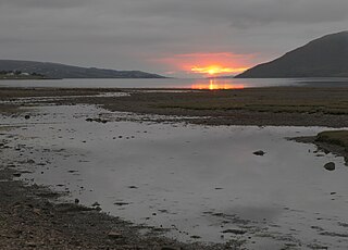
Loch Broom is a sea loch located in northwestern Ross and Cromarty, in the former parish of Lochbroom, on the west coast of Scotland. The small town of Ullapool lies on the eastern shore of the loch.

The A832 is a road in the Scottish Highlands, linking Cromarty, on the east coast, to Gairloch on the west coast, and beyond Gairloch to Braemore Junction. It is 126 miles (203 km) long and runs entirely in the former county of Ross and Cromarty. The road forms part of the Wester Ross Coastal Trail.

U.S. Route 75 was a part of the United States Numbered Highway System that runs for 1,239 miles (1,994 km) from Dallas, Texas to Kittson County, Minnesota where it ends just short of the Canada–United States border. Within the State of Nebraska it is a state highway that enters Nebraska on the Kansas state line about 9 miles (14 km) south of Dawson and travels north across the extreme eastern portion of the state, to the Nebraska–Iowa border in South Sioux City where it crosses the Missouri River along a concurrency with Interstate 129. The northern 210 miles (340 km) of the route generally travels parallel to the Missouri River. The 87.32-mile (140.53 km) section between the I-680 interchange in Omaha and the Interstate 129 interchange is designated the Lewis & Clark Scenic Byway, one of nine scenic byways in the state.
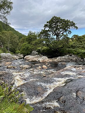
Ardessie is a small hamlet on the south western shore of Little Loch Broom, two miles northwest of Dundonnell, in Garve, Ross-shire, in the Highland region and is in within the Scottish council area of Highland. Scotland.
Dundonnell is a village in Ross and Cromarty, Scotland, on the south side of Little Loch Broom and at the foot of An Teallach, right at the north of the area commonly known as the "Great Wilderness". It is situated on the A832 road, 30 miles (48 km) east of Gairloch and 13.4 miles (21.6 km) west of Braemore Junction.
The Boomi River, an anabranch of the Barwon River and part of the Macintyre catchment within the Murray–Darling basin, is located in the north–western slopes region of New South Wales, flowing downstream into the South Downs region of Queensland, Australia.
Coolongolook River, a watercourse of the Mid-Coast Council system, is located in the Mid North Coast district of New South Wales, Australia.
Niemur River, a perennial stream of the Murray catchment and part of the Murray–Darling basin, is located in the western Riverina region of south western New South Wales, Australia.
Dundonnell Wind Farm is at Dundonnell, 23 kilometres (14 mi) northeast of Mortlake in the Australian state of Victoria. Construction began in January 2019 and was completed in 2020 with 80 Vestas wind turbines with a capacity to generate 336MW of electricity. The drive trains and hubs were assembled at the former Ford Australia site in Geelong.