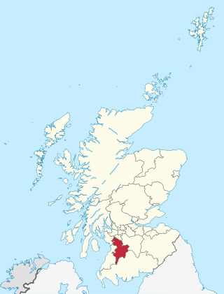
East Ayrshire is one of 32 unitary council areas of Scotland. It shares borders with Dumfries and Galloway, East Renfrewshire, North Ayrshire, South Ayrshire and South Lanarkshire. The headquarters of the council are located on London Road, Kilmarnock. With South Ayrshire and the mainland areas of North Ayrshire, it formed the former county of Ayrshire.
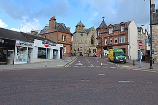
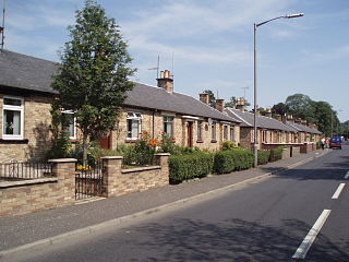
Cumnock is a town and former civil parish located in East Ayrshire, Scotland. The town sits at the confluence of the Glaisnock Water and the Lugar Water. There are three neighbouring housing projects which lie just outside the town boundaries, Craigens, Logan and Netherthird, with the former ironworks settlement of Lugar also just outside the town, contributing to a population of around 13,000 in the immediate locale. A new housing development, Knockroon, was granted planning permission on 9 December 2009 by East Ayrshire Council.

The River Dove is the principal river of the southwestern Peak District, in the Midlands of England, and is around 45 miles (72 km) in length. It rises on Axe Edge Moor near Buxton and flows generally south to its confluence with the River Trent at Newton Solney. From there, its waters reach the North Sea via the Humber Estuary. For almost its entire course it forms the boundary between the counties of Staffordshire and Derbyshire. The river meanders past Longnor and Hartington and cuts through a set of deep limestone gorges, Beresford Dale, Wolfscote Dale, Milldale and Dovedale.

The River Ayr is a river in Ayrshire, Scotland. At 65 km (40 mi) it is the longest river in the county.

Ochiltree is a conservation village in East Ayrshire, Scotland, near Auchinleck and Cumnock. It is one of the oldest villages in East Ayrshire, with archaeological remains indicating Stone Age and Bronze Age settlers. A cinerary urn was found in 1955 during excavation for a new housing estate.

The River Garnock, the smallest of Ayrshire's six principal rivers, has its source on the southerly side of the Hill of Stake in the heart of the Clyde Muirshiel Regional Park. About a mile and a half south of this starting point the untested stream tumbles over the Spout of Garnock, the highest waterfall in Ayrshire, once thought to be the river's origin. The river then continues, for a total length of 20 miles (32 km) or so, through the towns of Kilbirnie, Glengarnock, Dalry and Kilwinning to its confluence with the River Irvine at Irvine Harbour.

The River Irvine is a river that flows through southwest Scotland. Its watershed is on the Lanarkshire border of Ayrshire at an altitude of 810 feet (250 m) above sea-level, near Loudoun Hill, Drumclog, and 7 miles SW by W of Strathaven. It flows 29+1⁄2 mi (47.5 km) westward, dividing the old district of Cunninghame from that of Kyle, until it reaches the sea via Irvine Harbour in the form of the Firth of Clyde, and flows into Irvine Bay by the town of Irvine. It has many tributaries, some of which form parish, district and other boundaries.
Lugar is a small village in East Ayrshire, southwest Scotland. Lugar is in Auchinleck Parish, Kyle District, Ayrshire. It is 1.5 miles (2.4 km) ENE of Cumnock, and about 1-mile (1.6 km) from Cronberry and 2 miles (3.2 km) from Gaswater. Lugar was a station on the Mauchline and Muirkirk branch of the Glasgow and South Western Railway. Lugar is about 16.5 miles (26.6 km) SE of Kilmarnock.

Cleeves Cove or Blair Cove is a solutional cave system on the Dusk Water in North Ayrshire, Scotland, close to the town of Dalry.

Terringzean Castle, also Taringzean, pronounced 'Tringan', is a Category B listed castle ruin lying above the River Lugar and the Terringzean Holm in the policies of Dumfries House, Parish of Cumnock, Scotland. The name Craufordstone or Craufurdstoun, has also been used, echoing that it and these lands originally belonged to the Crawfords, as did Lefnoreis Castle or Lochnorris Castle which once stood near the site of the Dumfries House stables.

Black Loch is a freshwater loch, named from its dark waters, situated in the East Ayrshire Council Area, between Cumnock and New Cumnock, lying in a glacial Kettle Hole mainly within the Parish of New Cumnock, with a small portion protruding into Old Cumnock Parish. It is said to be one of only two lochs or lakes in the world that have outflows running to two separate destinations. The 'Runner' is a deep and broad ditch that was dug many years ago to link the three lochs of Lowes, Black, and Creoch.

Loch o' th' Lowes, Lochside or Meikle Creoch Loch is a freshwater loch in the Parish of New Cumnock in the East Ayrshire Council Area, Scotland. One of three linked lochs, it is overlooked by the A76 road and is located in a glacial kettle hole.

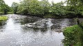
The Glaisnock Water is a tributary of the Lugar Water in East Ayrshire, Scotland. It passes under the Glaisnock Viaduct. The source is located south of the town of Cumnock, through which it flows.

The Lands of Borland or Boreland formed a castle and land holdings within the old Barony of Cumnock, East Ayrshire, Parish of Old Cumnock, Scotland. Lying two miles south of Cumnock the property was mainly held by a cadet branch of the Hamilton family from around 1400 before passing by marriage to the Montgomeries and others. For consistency the spelling 'Borland' will be used throughout.

Peden's Cave is at least partly artificial and is set into a craggy outcrop of red sandstone rocks overlooking the River Lugar just below the farm of Auchinbay in East Ayrshire, Scotland, close to the town of Ochiltree. Traditionally it is said that this cave was used as a hiding place for Covenanters, including the famous Covenanter minister Alexander Peden in the 17th century, mainly during 'The Killing Time' of the 1680s.

Wallace's Cave in the Lugar Gorge at Auchinleck in the Parish of Auchinleck, East Ayrshire is an 18th-century grotto, contemporary with Dr Johnson's Summerhouse which is also located on the Auchinleck Estate. It shows superior workmanship and is possibly the enlargement of a pre-existing cave. The cave or grotto lies downstream of the confluence of the Dippol Burn with the River Lugar and is reached via a once well formed path; however access is now hazardous due to the condition of the cliff edge path and the vertical drop into the River Lugar.

The site of the old Lefnoreis Castle or Ward of Lochnorris lies about 100 yards north-west of the old stable block of Dumfries House in East Ayrshire, Parish of Old Cumnock, Scotland. The old castle stood on a natural rise overlooking the Lugar Water, built and held for many years by the Craufurd family. For consistency the spelling Craufurd will be used throughout and Lefnoreis for the castle.

Murdoch's Cave, is a relatively small artificial cave created by William Murdoch (1754-1839) and his siblings in the soft red sandstone Lugar river bank cliff just upstream of the old Bellow Mill close to the confluence of the Bellow or Bello Water and the Glenmuir Water in Lugar, East Ayrshire, Scotland. The spelling 'Bellow' is used for consistency.

The Glenmuir Water is a river in Ayrshire, Scotland.The river rises high in the hills south of Muirkirk. On reaching Lugar the Glenmuir is joined by the Bellow Water and is renamed the Lugar Water. Ayrshire Rivers TrustArchived 7 March 2021 at the Wayback Machine monitor water quality for the river and visit annually.

 Confluence of the Lugar and Ayr rivers, Barskimming, Ayrshire
 The Slatehole Ford, River Lugar, East Ayrshire, Scotland
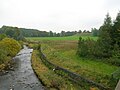 The River Lugar with Taringzean Castle to the right
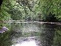 Peden's Cave view, River Lugar Gorge, East Ayrshire, Scotland
 Chinese Bridge over River Lugar at Dumfries House
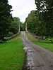 John Adam designed Avenue Bridge, Dumfries House


