The Gloucestershire Wildlife Trust is the Gloucestershire local partner in a conservation network of 47 Wildlife Trusts. The Wildlife Trusts are local charities with the specific aim of protecting the United Kingdom's natural heritage. The Gloucestershire Wildlife Trust is managed by a Board of Trustees elected from its membership who provide overall direction for the development of the Trust and there are Advisory Committees. The work of the trust is carried out through staff and volunteers.

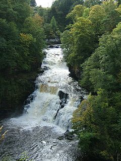
The Falls of Clyde is the collective name of four linn on the River Clyde near New Lanark, South Lanarkshire, Scotland. The Falls of Clyde comprise the upper falls of Bonnington Linn, Corra Linn, Dundaff Linn, and the lower falls of Stonebyres Linn. Corra Linn is the highest, with a fall of 26 metres (84 ft). Bonnington Linn, Corra Linn and Dundaff Linn are above New Lanark and located within the Falls of Clyde Reserve managed by the Scottish Wildlife Trust, a national nature conservation charity. Stonebyres Linn is located several miles downstream from the reserve and New Lanark.

Insh Marshes are an area of floodplain of the River Spey between Kingussie and Kincraig in Badenoch and Strathspey, Highland, Scotland. The marshes are said to be one of the most important wetlands in Europe. They lie at altitude of approximately 240 to 220 m above sea level, and form one of the largest areas of floodplain mire and fen vegetation in Scotland.
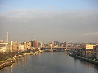
The Clyde Walkway is a foot and mountain bike path which runs from Glasgow, Scotland, to just above the UNESCO World Heritage site of New Lanark. The path runs close to the River Clyde for most of its length. It was completed in 2005, and is now designated as one of Scotland's Great Trails by Scottish Natural Heritage. The route is 65 kilometres (40 mi) long, and combines rural sections on the upper Clyde in South Lanarkshire, including the Clyde Valley Woodlands National Nature Reserve and the Falls of Clyde, with urban walking through the centre of Glasgow. About 155,000 people use the path every year, of whom about 7,750 undertake multi-day journeys.

Glen Affric is a glen south-west of the village of Cannich in the Highland region of Scotland, some 15 miles (24 km) to the west of Loch Ness. The River Affric runs along its length, passing through Loch Affric and Loch Beinn a' Mheadhoin. A minor public road reaches as far as the end of Loch Beinn a' Mheadhoin, but beyond that point only rough tracks and footpaths continue along the glen.

Glen Roy in the Lochaber area of the Highlands of Scotland is a national nature reserve noted for the geological puzzle of the three roads. The "Parallel Roads" of Glen Roy are loch terraces that formed along the shorelines of an ancient ice-dammed loch. The loch existed during a brief period of climatic deterioration, during a much longer period of deglaciation, subsequent to the last main ice age. From a distance they resemble man-made roads running along the side of the Glen, hence the name.
Cleghorn covers a large area and is part of Lanark in South Lanarkshire, Scotland.it is in the catchment area of Lanark Grammar School. Cleghorn Village is a small close community with about 250–300 residents, and under 50 houses.

Nethan Gorge is a natural gorge carved by the River Nethan, located in South Lanarkshire, Scotland.
Mauldslie Woods is an area of woodland close to the town of Carluke, South Lanarkshire. It is one of six woodlands which form the Clyde Valley Woodlands National Nature Reserve, the others being Cartland Craigs, Chatelherault, Cleghorn Glen, Falls of Clyde and Lower Nethan Gorges.
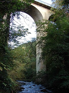
Cartland Bridge is a road bridge on the A73 north-west of Lanark, South Lanarkshire which spans the Mouse Water, a tributary of the River Clyde. The three-span bridge was built in 1822, to designs by the engineer Thomas Telford. It is notable for being the highest bridge over inland water in Scotland. It is a category B listed building.
The Seven Lochs Wetland Park is an urban park that is due to be created in Scotland. It will comprise nearly 20 km² of land and water between Glasgow and Coatbridge.

Loch Lomond National Nature Reserve (NNR) encompasses 430 hectares of land at the southeastern part of Loch Lomond in the council areas of Stirling and West Dunbartonshire, in Scotland. It covers the islands of Inchcailloch, Clairinsh, Torrinch, Creinch and Aber Isle, alongside areas of woodland and wetlands to either side of the mouth of the Endrick Water. Scottish Natural Heritage (SNH) owns two parts of the reserve - the island of Inchcailloch and part of Gartfairn Wood - and the rest is privately owned. The reserve is managed by a partnership consisting of SNH, the Royal Society for the Protection of Birds (RSPB) and the Loch Lomond and The Trossachs National Park, along with the owners and tenants of the land under agreements. Within this framework SNH directly manage the islands of Clairinsh, Inchcailloch, Torrinch and Creinch, and land to the north of the Endrick Water. The RSPB manages the area to the south of the Endrick Water, and the National Park manages visitor facilities on Inchcailloch.

Glen Tanar is a glen in Aberdeenshire, eastern Scotland, through which the Water of Tanar flows. Near the mouth of the glen, at Tower o' Ess, the Water of Tanar flows into the River Dee. This flows through Deeside into the North Sea at Aberdeen. Glen Tanar contains the third largest area of Caledonian Forest in Scotland, and is of national and European importance.

The Upper Tweeddale National Scenic Area lies in the Borders region of Scotland. It is one of 40 national scenic areas (NSA) in Scotland, which are defined so as to identify areas of exceptional scenery and to ensure their protection from inappropriate development. The designated area covers 12,770 ha of countryside surrounding the upper reaches of the River Tweed between Broughton and Peebles.

Glen Nant is glen lying to the south of Taynuilt in the Argyll and Bute council area of Scotland. An area of woodland of 339 hectares on the western side of the River Nant is designated as national nature reserve (NNR), which is owned and managed by Forestry and Land Scotland (FLS). It is an example of an Atlantic Oakwood, and is one of largest areas of upland oak woodland in north Argyll.
Invereshie and Inshriach is a national nature reserve on the western flank of the Cairngorms in the Highland council area, Scotland. The reserve covers habitats at a range of different altitudes, ranging from Caledonian Forest beside the River Feshie in the west, via bog and open moorland, to an arctic-alpine environment on the Cairngorm plateau. The Munro summit of Sgòr Gaoith (1118 m) lies on the eastern boundary of the reserve. The forested areas of the reserve form part of an expanse of Caledonian pinewood that stretches from Glen Feshie to Abernethy, and which as a whole forms the largest single area of this habitat remaining in Scotland. The reserve is owned and managed jointly by Scottish Natural Heritage (SNH) and Forestry and Land Scotland (FLS): SNH own the Invereshie portion of the reserve and FLS the Inshriach area.