
South Lanarkshire is one of 32 unitary authorities of Scotland. It borders the south-east of the City of Glasgow and contains some of Greater Glasgow's suburbs,also containing many towns and villages. It also shares borders with Dumfries and Galloway, East Ayrshire, East Renfrewshire, North Lanarkshire, the Scottish Borders and West Lothian. It includes part of the historic county of Lanarkshire.

Rutherglen is a town in South Lanarkshire, Scotland, located immediately south-east of the city of Glasgow – 3 miles (4.8 km) from its centre – and directly south of the River Clyde. Having existed as a Lanarkshire burgh in its own right for more than 800 years, in 1975 Rutherglen lost its own local council and administratively became a component of the City of Glasgow District Council within the Strathclyde region. In 1996 the towns were reallocated to the South Lanarkshire council area.

Cambuslang is a town on the south-eastern outskirts of Glasgow, Scotland. With approximately 30,000 residents, it is the 27th largest town in Scotland by population, although, never having had a town hall, it may also be considered the largest village in Scotland. It is within the local authority area of South Lanarkshire and directly borders the town of Rutherglen to the west. Historically, it was a large civil parish incorporating the nearby hamlets of Newton, Flemington, Westburn and Halfway.

Blantyre is a town and civil parish in South Lanarkshire, Scotland, with a population of 16,900. It is bounded by the River Clyde to the north, the Rotten Calder to the west, the Park Burn to the east and the Rotten Burn to the south.

Carmyle is a suburb in the east end of Glasgow, Scotland, directly north of the River Clyde. It is in an isolated location separated from the main urban area of the city and has the characteristics of a semi-rural village. Administratively, Carmyle falls under the Shettleston ward of Glasgow City Council.
Carntyne is a suburban district in the Scottish city of Glasgow. It is situated north of the River Clyde, and in the east end of the city. Since 2007 it has formed the core of the East Centre ward under Glasgow City Council, which also includes the neighbouring Riddrie and Cranhill areas.
Sandyhills is an area of the Scottish city of Glasgow. It is situated north of the River Clyde and has fallen within the Shettleston ward of Glasgow City Council since 2007.

Eastfield is a mainly residential district in Scotland, sandwiched between the South Lanarkshire industrial towns of Rutherglen and Cambuslang in the south-east of the Greater Glasgow urban area. It is situated south of the River Clyde, adjoining the Stonelaw and Burnside neighbourhoods of Rutherglen, and Silverbank in Cambuslang.

Dalmuir is an area nine miles north-west of Glasgow, Scotland, on the western side of Clydebank, and part of West Dunbartonshire Council Area. The name is a lowland Scots derivation of the Gaelic meaning Big Field. The area was originally two separate villages with Dalmuir Shore joining with Clydebank in 1886 and Dalmuir Village in 1906, during a period of rapid industrialization and expansion. Dalmuir is bounded by the village of Old Kilpatrick to the west, the Mountblow and Parkhall housing schemes to the north, and the Clydebank town centre area to the east. To the south is the River Clyde.
Braidfauld is a small area of Glasgow, Scotland which is in the East End of the city slightly north of the River Clyde and south of the Tollcross area. It was also the name of the 45th ward of Glasgow City Council, prior to the re-organisation into multi-member wards in 2007.

Burnside is a mostly residential area in the town of Rutherglen in South Lanarkshire, Scotland. Including the neighbourhoods of High Burnside and High Crosshill, respectively south and north-west of its main street, it borders Overtoun Park in Rutherglen plus several other residential areas of the town, as well as western parts of neighbouring Cambuslang.

Kirkhill is a district of the town of Cambuslang, South Lanarkshire, Scotland.
Cambuslang is an ancient part of Scotland where Iron Age remains loom over 21st century housing developments. The History of Cambuslang mirrors and gives life to the general History of Scotland. The geography of Cambuslang explains a great deal of its history. It has been very prosperous over time, depending first upon its agricultural land, then the mineral resources under its soil.

Craigneuk is a suburb of Wishaw, North Lanarkshire, Scotland. The original village of Craigneuk was located in the area where Meadowhead Road meets Glasgow Road. It was originally part of Dalziel parish along with the other rural weaving villages of Flemington, Motherwell and Windmillhill. Craigneuk village was located close to the boundary with Cambusnethan parish.

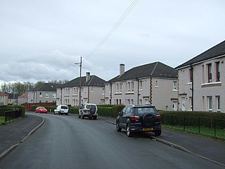
Halfway is a largely suburban area in the town of Cambuslang, Scotland, located within the local authority area of South Lanarkshire. It borders the smaller areas of Lightburn, Cairns, Flemington, Drumsagard and Hallside.

Drumsagard Village is a new construction village in Cambuslang, South Lanarkshire. It is built around the site of Drumsagard Castle and immediately south of the site of Hallside Steelworks, also known as the Cambuslang Iron and Steel Works. One of the first facilities of their kind and eventually extending over an area of around 33 acres, the steelworks were established in 1873 and closed in 1979.

Newton is a mainly residential district in the town of Cambuslang in Scotland. It is situated south of the River Clyde; the river directly borders the district to the north. Newton is within the Cambuslang East ward of the South Lanarkshire Council area.

Westburn is a district of the town of Cambuslang in South Lanarkshire, Scotland. It was formerly home to a steel works and power station which were the area’s major employers; the sites are now occupied by a housing development and modern industrial estate respectively. Administratively, Westburn is within the Cambuslang East ward of the South Lanarkshire Council area and has a population of around 2,000.
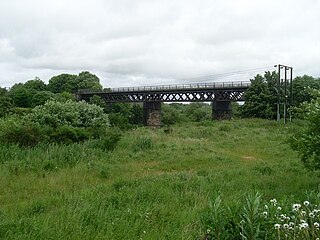
Westburn Viaduct, also known as Carmyle Viaduct, is a disused railway bridge over the River Clyde between Carmyle in Glasgow and Westburn (Cambuslang) in South Lanarkshire. It is constructed of a steel lattice frame with sandstone pillars and has three main spans over the water.

Cambuslang East is one of the twenty wards used to elect members of the South Lanarkshire Council. Created in 2007, it elects three councillors.


